FRIDAY March 11, 2016
WEATHER: arrived at Tucson, the temp was
85
TRAVEL: Davis-Monthan AFB
The flight from Milwaukee
to Phoenix was full of
people visiting spring training for the Brewers – part of them was a group of 4
guys from Burlington. If I was a Little
League guru – I think I would know them
. . . I knew the face of one of
them – don’t think they recognized me.
We landed 55
minutes early, couldn’t get to the gate for a ½ hour. Flew to Tucson - I almost got on a plane and
turned back – but that is another story.
Got a cab to Davis-Monthan and out to the trailer storage
site. My truck started immediately. –
hooked up the trailer and drove to Agave Gulch FamCamp – 1st come 1st
served. I was lucky – I got the last
available site.
Agave Gulch FamCamp is the best military camp I’ve stayed at – clean,
great weather, up-to-date, WIFI
works most of
the time. Davis-Monthan is an outstanding base. There was an Air Show going on this weekend –
featuring the precision flying Air Force Thunderbirds.
It is my understanding that they alternate the air show date with the
Navy’s Blue Angels.
SATURDAY March 12, 2016
WEATHER: 51 at 4:30 am; a sunny day with
some wind - high of 70.
TRAVEL: Davis-Monthan AFB
A laid back day.
I changed out the tires on the trailer at a dealer just down the road –
great service. Late in the day decided
that I will continue the trip – see what happens . . . . bought groceries, and
prepared for the next 4 weeks verifying travel plans and updating the
blog.
Went to 5pm mass at
Christ the King Catholic Community at the Davis-Monthan Deseert Dove Chapel. Same choir as in December . . .
. . . Easter is only two weeks away – hard to believe.
SUNDAY March 13, 2016
WEATHER: 43 at 5:30 am, clear and sunny
TRAVEL: Davis-Monthan AFB
MONDAY March 14, 2016
 |
| Lordsburg rated a marker. My guess of the Sourthern Pacfic seems correct. |
TRAVEL: Davis-Monthan AFB , Tucson, AZ to Lordsburg,
NM
 |
| Trailer & truck at Lordsburg, NM KOA |
TUESDAY March 15, 2016
WEATHER: 47 at 4:30 am clear sky, plenty
of stars to the south, must have got up to the 60’s – pleasant still short
sleeve weather with the sun – plenty of wind during the day on the flat - down to 38 as I traveled in the mountains
Lordsburg: Sunrise 0723; Sunset 1924; Moonrise 1137 waxing
crescent 47% illumination, Moonset 0047
 |
| This mountain forest was stunning - even with the narrow road - it was just a wonderful drive. |
 |
| This was just outside Silver City |
We’ve got to thank
Aldo Leopold.- I read his “Sand County Almanac” as part of a graduate philosophy course - a conservation
ethic – worth reading.
 |
| Gila Cliff Dwellings Gila Wilderness |
For thousands of years, groups of nomadic people used the caves of the Gila River as temporary shelter. In the late 1200's, people of the Mogollon Culture decided it would be a good place to call home. They built rooms, crafted pottery and raised children in the cliff dwellings for about twenty years. Then the Mogollon moved on, leaving the walls for us as a glimpse into the past.
 |
| Thank you Aldo |
Early in his career, Aldo Leopold was assistant district forester
for the Southwest national forests. He
persuaded his agency to establish the Gila Wilderness in 1924, the nation’s first wilderness
are. Now the Gila Wilderness protects the
upper Gila River watershed – the longest
undammed stretch of river in the lower 48.
Leopold’s vision helped inspire the 1964 Wilderness Act
that now preserves the wildness of over 109 million acres of public federal
lands.
There is a small Visitor Center with a museum
displaying Mogollon
artifacts from the Gila Cliff
Dwellings and surrounding area. There is also an exhibit on the Chiricahua Apache who consider the
wilderness to be their homeland. A 15-minute video illustrates the Mongollan culture and the Cliff Dwellings.
 |
| Gila Cliff Dwellings Trail map |
 |
| Gila Cliff Dwellings from tail |
 |
| These dwelling are significant because they were built by the Mongollon. Probably influenced by the Pueblo and tribes to the north. Tonto National Monument is better and Mesa Verde may be the the King of cliff dwellings. |
 |
| This is the Middle Fork of the Gila River ford. Way over my ankles and I didn't have water shoes. |
 |
| Alternate crossings over the Middle Fork of the Gila River did not look promising. My legs are not that long. |
The most
popular hot spring is Jordan,
a 6 or 8 mile hike from the Visitor
Center,
depending upon the trailhead used. Private hot springs are also located in the
community of Gila Hotsprings,
four miles from the Monument. You are urged to use caution if entering the hot
springs because the Hot springs may contain an amoeba that may cause a form of
meningitis that can be fatal. Don't get water up your nose or just stay away
from the Hot Springs. Nice.
 |
| The geology of Arizona and New Mexico is interesting. A great palce for a geologist or rock hound. Pictures do not do the country justice. |
WEDNESDAY March 16 2016
WEATHER: 42 at 5:30, 48 in the trailer –
clear sky;
LORDSBURG Sunrise 0722; EL PASO Sunset 1915; Moonrise 1324
waxing gibbous 59% illumination, Moonset 0233
TRAVEL: Lordsburg NM to Fort Bliss RV Park, El Paso,
TX to Chamizal National Monument to Fort Bliss to Fort Bliss RV
Park. Seems like the wind let up . . . .
there is a breeze but not rocking the trailer.
 |
| Entrance Ft. Blss RV Park Shopette & Subway right across the street |
 |
| Ft. Bliss RV Park site |
Got here early
enough to start reading “The
Civil War In Arizona: The Story of the
California Volunteers, 1861-1865” written by Andrew E. Masich, published by University
of Oklahoma Press. A regiment of California infantry and cavalry
started east to fight Texas rebels in Arizona and New Mexico – ending up
fighting Apaches mostly.
271 CHAMIZAL National Memorial, El Paso, TX
 |
| Chimazal National Memorial |
Chamizal is an urban park whose grounds stand for
peace. The peaceful settlement of a
100-year border dispute between nations. Not one shot was fired; not one war
was waged. The memorial celebrates the culture of the borderland that helped to
peacefully navigate an international argument.
 |
| This is what it was all about The Rio Grande channel changed What was part of Mexico now was part of the US when the River cut changed |
 |
| A concrete river channel was built to define the border |
This is a nice Visitor Center and park literally on
the border . . . . the VC auditorium and
surrounding park are used for cultural events throughout the year.
Fort Bliss is home to Air Defense
Artillery. The post has a Mall/PX/Commissary complex - unique to any Army post I’ve been
on. A true Outdoor Mall with Buffalo Wild Wings, barber shop,
Class Six (liquor store), Texas Roadhouse, Vitamin
stores, an Irish Pub, opticians, a theatre complex, commissary,
etc. I’ll post a picture of this
eventually – actually to large for one picture – but I think I found my Irish Bar for St. Patrick’s Day. Getting on and off post can be challenging because
it is in or on the edge of El Paso. There are roads running under roads, which at
first glance, make it all very confusing.
I passed the Underwood
Golf Course Complex returning to
the RV Park – it’s right across US 54 but it looks like I have to go past it
going South and make a U-turn in order
to get to it.
THURSDAY March 17 2016
WEATHER: 52 at 4:30 am clear – up to 78
sunny
EL PASO Sunrise 0713 Sunset 1916; Moonrise 1419 waxing gibbous 75%
illumination, Moonset 0324
 |
| Shamrocks Pub - Ft. Bliss mall |
 |
| Ft. Bliss mall this band turned out to play RAP |
ST. PATRICK’S DAY – after the visit to White Sands I went to an Irish pub located on the mall of Ft. Bliss – just across from Buffalo Wild Wings – in the Freedom Crossing Mall at Fort Bliss - a lot going on and I had a green beer.

Rising from the heart of the Tularosa Basin is one of the world's great natural wonders
- the glistening white sands of New Mexico. Great wave-like dunes of gypsum sand have
engulfed 275 square miles of desert, creating the world's
largest gypsum dune-field. White Sands National
Monument
preserves a major portion of this unique dune-field, along with the plants and
animals that live here.
The adobe Visitor Center
and
adjacent buildings were built in the years 1936-1938 by the Works Progress Administration.
There is an 18 minute film , small museum and bookstore at the VC. A separate concessionaire runs a Gift Shop attached to the VC. The big draw here is the rental of sleds –
for sand sledding. I would call them saucers – but there may be
some sensitivity to that word because Roswell is not far
away.

If you walk the trails this is a full day –
get here early before it gets to hot.
Most of the people I saw here came for sand sledding. A drive through is about an hour or so.
The dunes, brilliant and white, are
ever-changing. They grow, crest, then
slump, but always advance. Nothing else
like this in the world. Easier to walk
on than the Sleeping Bear Dunes NP in Michigan. The sand here is white, cool and clean. Most brown seashore sand is made of seashells
and fish poop.
 |
| Sand Sledding - on a saucer It's spirng break and there were literally hundreds of people sledding - close to the roads Some of the dunes are higher this this |
 |
| White Sands map |
The Dunes Drive leads from the Visitor Center eight miles into the heart of the dunes. There are five marked trails. I walked three; the short Dune Life Nature and Playa Trails were closed for restoration.
Playa Trail Length: 330 yards (300 m) round-trip Average Completion Time: 20 minutes
Difficulty: Easy. Dune Life Nature Trail Length: One mile (1.6 km) loop Average Completion Time: 1 hour Difficulty:
Moderate
I walk trails . . .
. . other than it is the only way to ‘see’ the land, a park brochure quoted Albert
Einstein as saying “ the
only way to gain knowledge is through experience.” I get it.
 |
| The sand is very fine - soft |
 |
| Backcountry Trail map |
 |
| Backcountry Loop Trail |
 |
| I 'm not fond of baseball caps but wearing one instead of my bush hat was a good ideal |
 Alkali Flat Trail – a 5 mile hike that took 2 ½ hours to complete. A challenge because of its length and going
up and down dunes. This is a true wilderness
walk – I came across a young couple who started just 10 minutes before me but
decided to turn around after a little more than two miles. The first mile is tough, due to some steep
climbs. The halfway mark is the Alkali
Flats where the trail
skirts the edge of the final remnant of Lake Otero, once a 1,600 square mile lake. I didn’t see any water.
Alkali Flat Trail – a 5 mile hike that took 2 ½ hours to complete. A challenge because of its length and going
up and down dunes. This is a true wilderness
walk – I came across a young couple who started just 10 minutes before me but
decided to turn around after a little more than two miles. The first mile is tough, due to some steep
climbs. The halfway mark is the Alkali
Flats where the trail
skirts the edge of the final remnant of Lake Otero, once a 1,600 square mile lake. I didn’t see any water.
There is a CAUTION
not to hike this trail between after 10 am – 5 pm , May through August. I went through 2 ½ bottles of water. Glad I wore a baseball cap, I did get a mild sunburn
– sides of the neck where I missed putting on sunscreen. This trail ranks at the top - along
with the Kaluapapa
NM Trail in Molokai, the Cave
Trail at Timpanogos
NM, the Golden Canyon/Gower
Gulch Trail in Death
Valley NP and the Mauna
Ula Trail in Hawaii Volcanoes NP.
 |
| Alkali Flat Trail Mile Marker 2 San Adreas Mountains & Alkali Flat |
 |
| Alkali Flt Trail |
 |
| Alkali Flat Trail Mile MArker 1 |
 |
| Alkali Flat Trail - where the Alkali Flat starts to form the dunes Mile Marker 2 |
 |
| Alkali Flat Trail - a crescent shaped dune - in the "heart of the dunefield" San Adreas Mountains in the background - not quite to Alkali Flats |
Interdune Boardwalk Length: 650 yards A short, easy walk up and back of 15 minutes. Not much going on here.
FRIDAY March 18 2016
WEATHER: 57 at 5:30 am clear.
EL PASO Sunrise 0712; Sunset 1917; Moonrise 1515 waxing gibbous
83% illumination, Moonset 0410
TRAVEL: Fort Bliss Underwood Golf Course
Another year and a prayer
 |
| Fort Bliss Underwood Golf Complex Clubhouse |
 |
| Underwood Golf Complex Sunset Course |
Underwood Golf Complex has two 18 hole golf courses. The Sunset Course was built in 1953 – a standard Army golf course. – fairly flat – narrow – tree lined. The Sunrise Course is more of a lynx style – water hazards – more spread out. Twilight rates take effect at noon – probably because of the heat – I started walking the Alkali Flat Trail at White Sands National Monument yesterday around noon – for $20 I’ll start after noon.
I played the Sunrise Course, a “desert links” course – fairly straight the rough is rock/desert. I shot a 49 on the front nine and a 45 on the back nine – with 3 balls in the sand traps and 1 lost water ball – on the 18th hole. I may straighten my drive out yet – hope to by April.
SATURDAY March 19 2016
A Birthday and St. Joseph’s Day
WEATHER: 43 at 5:30 am – I left around
7:40 am – it was cool and the forecast called for winds around 30-40 mph and
gusts of 60 in the mountains – the stormy winds never materialzed . EL
PASO Sunrise 0710 Sunset 1917; Moonrise
1610 90.2% illumination, Moonset 0453
TRAVEL: Fort Bliss RV Park to Guadalupe
Mountains NP to Carlsbad
Caverns NP, back to Guadalupe and return to Fort
Bliss. Most of the route was 75 mph. After 2 hours , I reached the mountains –
they were in the clouds so it was foggy and cold. It was 27 degrees and very foggy at the Guadalupe
Mountains Pine Springs Trailhead.
Still there were
a lot of people ready to hike . . . too
cold and there was nothing to see. I had
alternatives. Another 45 minutes on the
road brought me to Carlsbad Caverns NP – the cave has a year round temperature of 57
degrees..
 |
| It was foggy I found the sign but missed the Visitor Center |
 |
| Guadalupe VC the foot bridge leading here was coverd in salt today It was 27 degrees and foggy |
Guadalupe Mountains National Park is the world's
premier example of a fossil reef from the Permian Era. The park
is known for its extensive hiking and backpacking opportunities in one of the
nation's most pristine wilderness areas.
 |
| Guadalupe Trails Map |
A hiker's paradise – not much else to do at Guadalupe Mountians NP. There are more
 |
| Guadalupe NP Trail Descriptions |
The Visitor Center
was sparse – no bookstore to speak of – good exhibits on the geology - the two
younger rangers seemed more interested in talking to each other than talking to
people.
 |
| Guadalupe Trailheads |
Smith Spring Loop - the Smith Spring Trail is 2.3 miles (round-trip) and departs from
the Frijole Ranch Trailhead. Watch the landscape change from desert scrub to
riparian vegetation in this loop.
McKittrick Canyon
Nature Trail a 1
mile loop of the 7.4 mile one-way McKittrick Canyon Trail that leads to McKittrick Campground.
274 CARLSBAD CAVERNS National Park, Carlsbad, NM

 The Visitor
Center is located about 9
miles off US Highway 62/180,
approximately 45 miles northeast of Guadalupe Mountains NP Pine
Spring Visitor Center.
The Visitor
Center is located about 9
miles off US Highway 62/180,
approximately 45 miles northeast of Guadalupe Mountains NP Pine
Spring Visitor Center.
The bookstore was
in transition – i.e. there was none while a new vendor contract was being
negotiated with Western National. There is a large tourist trinket
store and restaurant in the VC but not a “bookstore.”
I bought a small
pamphlet book entitled “Jim White’s Own Story: The Discovery and
History of Carlsbad Caverns.” James Larkin White was a cowboy who explored and
worked in the cave. The short pamphlet
book was published in 1931 and written by Frank Ernest Nicholson. Jim White was uneducated but served as explorer, guano foreman, guide, park ranger
and custodian. He loved the cave. A preface to the pamphlet written by Bob
Hoff, Park Historian,
in 1998 says it “contains elements of
fact and fiction . . . Some parts of the book were sensationalized
to capture a wider reading public.”
Indeed, you can find the sensational – or exaggeration in some of the
short stories – but there is no doubt that Jim White’s efforts led to the creation of Carlsbad
Cavern National Park in 1929, 37 years
after he had “discovered” the cave.
The book has a map of the cave with numbered
stops that appear to match what you find in the cave. There was no printed guide available to
identify the numbered stops in the cave.
 |
| Carlsbad Cavern Natural Entrance |
 |
| The black shapes are bats Photo taken when I was entering the cave There were no bats to be seen on the way out |

 |
| Carlsbad A good map of the Four American Deserts |
The evening bat flight of Carlsbad Cavern is a natural phenomenon. The ”bat cave” is still full of bat “guano” that was mined for fertilizer until 1957. The bat cave is not visited by people – it is ¾ mile long, 90-200 wide and approximately the same height. There is a definite odor. An amphitheater built by the CCC is in front of the entrance, where people can watch the mass-exodus of Mexican free-tail bats for a night of feasting on insects. There were some bats present when I visited – most of the bats winter in Mexico. If you want to see bats come May – October.
 |
| Carlsbad - a good map of the National Park Sites in the Southwest This is where I'm going to spend the next four months |
 |
| Carlsbad - The Permian Sea covered much of the land There is much moreof a geology story to tell than time allows |
 |
| Carlsbad Cavern Map - above and below ground |
 |
| Carlsbad Cavern Looking up at the Natural Entrance |
 |
| Carlsbad Natural Entrance Trail formation called the Whale Mouth |
 |
| Carlsbad Underground Gift Shop & Lunch Room |
Carlsbad Caverns is enormous. The largest rooms of any cave I’ve been in –
also the largest formations.
Rest rooms and a
cafeteria are located near the junction of the Natural Entrance Trail and the Big
Room Trail.
 |
| Big Room Trail Map |
The Big Room Trail is named for the largest single cave chamber in North America, covering an area equal to 6.3 football fields. This is an easy 1.25 mile loop paved trail, with just a couple of areas that are moderately steep. The trail leads you through a myriad of awe inspiring, yet delicate cave formations and ends near the elevators, cafeteria, and rest rooms.
 |
| Big Room Trail |
 |
| Big Room Trail Stalagmite |
 |
| Big Room Trail Draperies |
 |
| Big Room Trail - Bottomless Pit - not really bottomless |
 |
| Carlsbad - Imagine you are on a non-coral reef looking out at the bottom of a Permian Sea |
 |
| Carlsbad Cavern Amphiteater at the Natural Entrance - Built by the CCC also the adobe buildings above built by the CCC |
Driving out of the
park I came across the 9.5 mile gravel Walnut Canyon Scenic Drive. There was no brochure in the box – also
typical of National Parks – but I donated a dollar with the smallest denominations
of coins I had. There is a Rattlesnake
Canyon Trail along the route but without a map – like some of the Chiricahua
Mountain Trails – I did not venture in – also the name was not inviting
 |
| Carlsbad - Walnut Canyon Desert Drive |
 |
| Carlsbad - Walnut Canyon Desert Drive - Rattlesnake Canyon Overlook' I could have been walking a trial down there |
 |
| Guadalupe Mountains NP McKittrick Canyon |
 |
| Guadalupe Mountains NP McKittrick Canyon Trailhead |
Coming out of Carlsbad I had
to go through Guadalupe Mountains. I
stopped at the McKittrick Canyon trailhead – it does look like one of the least
traveled trails – an easy walk. There
was a VC/Contact Station here but it was not manned.
I also stopped again at the
main VC again. It was clear and in the
low 50’s. I checked with a ranger who
identified his two favorite trails as the ones I had decided to walk. Maybe Monday and hopefully – less people..
 |
| Blessed Sacrament Church El Paso, Texas |
WEATHER: 43 at 5:30 am, high in low 70’s,
clear & sunny
EL PASO Sunrise 0709 Sunset 1918; Moonrise 1715 95.3% illumination,
Moonset 0531
TRAVEL: Fort Bliss/El Paso area
PALM SUNDAY – I went to 9:30 am Mass at Blessed Sacrament Church – a drive of about 3 miles. No surprise – a mostly
Hispanic community.
I forgot to
mention that Ft. Bliss is also home to the 1st Armored Division and the Army’s Sergeants
Major Academy.
MONDAY March 21, 2016
WEATHER: clear 45 at 5:30 am; 60 at
Guadalupe with a steady wind, wore a long sleeved t shirt until 1130 EL PASO Sunrise 0708 Sunset 1919; Moonrise 1759 Moonset 0609
TRAVEL: Fort Bliss RV Park to Guadalupe Mountains NP to Fort Bliss RV Park
 |
| Guadalupe - alot of trails start at Pine Springs The Devil's Hall Trail is 4.2 miles with 800 ft in elevation |
Devil's Hall Trail - the Devil's Hall Trail departs from the Pine Springs Trailhead and
is 4.2 miles round-trip. After the first mile the trail enters a rocky wash
which leads hikers to an impressive natural rock staircase leading to a
"hallway" formed by steep canyon walls. I got to the staircase but did not walk up it
– hope I didn’t miss too much. The walk
up the wash was exciting enough. The
trail took me 2 hrs and 40 minutes to walk including a short sandwich break –
only got off the trail coming back once – found my way back.
 |
| Devil's Hall Trail The beginning easy to follow |
 |
| Devil's Hall Trail The staircase at the the end |
 |
| Devil's Hall Trail in the wash where is the trail now? |
 |
| Devil's Hall Trail at the end staircase - it was 1110 time to remove the long sleeve t shirt |
 |
| Devil's Hall Trail - the staircase at the end another view |
 |
| Guadalupe Butterfleld Adobe ruins |
 |
| Guadalupe Butterfield Ruins |
BUTTERFIELD OVERLAND MAIL – PINERY STATION
On
September 28, 1858, the Guadalupe Mountains saw the arrival
of the first Westbound stage of the Butterfield
Overland Mail
at Pinery Station in Guadalupe Pass. For
11 months the Butterfield Overland Mail passed through
the Guadalupe Mountains on its 2,800
mile bi-weekly route from St. Louis to San Francisco. It was a long, exhausting journey with all
too infrequent stops.

The Pinery Station, named for nearby forest of pine, maintained a change of horse and provided meals of venison pie and baked beans to stage drivers and weary travelers. Nearby Pine Springs supplied water for horse, drivers and thirsty travelers. In August 1859, Pinery was shut down as the Butterfield adopted a new southerly route that had more water and was better protected against Indian attacks.
There
is a short trail at the site.
 |
| Guadalupe - Frijole Ranch the spring is jsut ot hte right out of the picture it flows cosntant 6 gpm I filled up two water bottles at a water foudntain - the water was cool and delicious |
There
are six springs with a three mile radius – water was a natural magnet for early
settlers. The Rader Brothers built the first substantial house at the springs in 1876.
They operated a small cattle ranch but never filed a deed on the land,
they moved on.
In
1906 John Thomas Smith filed on the Frijole site calling it Spring Hill
Ranch. Smith had moved from
Wisconsin to Texas. The Smiths
raised ten children during their 36 year stay at the ranch.
The
Highway 62/180 alignment was established in the late 1920’s and paved in the
1930’s. As people moved through, the Smiths took in travelers who came to hunt.
In 1942, John Smith sold the Frijole Ranch to J.C. Hunter who had purchased much land in the area for a
commercial ranching operation.
After
the Smith’s moved out, the Frijole house served as home for Noel
Kincaid,
Hunter’s ranch foreman. In 1945 J.C. Hunter’s son inherited the ranch. He sold the 72,000 acre property to the National Park Service in 1966.
The Kincaid’s lived in the house until 1971 when their
lease expired.
Guadalupe National Park was officially
established in 1972. The museum was
closed when I visited. I id not walk any
of the trails that begin at this site.
 |
| Guadalupe Peak - the Guadalupe Moutnatains were home to the Mescalero Apahes |
 |
| Guadalupe Peak The highest point in Texas I did not walk to the top |
 |
| Guadlaupe - El Capitan - I guess Yosemite does not have a corner on the market for the name of ' El Capitan |
SALT BASIN DUNES TRAIL
On
the return trip to El Paso I took a side trip in an attempt to visit/find the Salt Dunes Trailhead. Just before entering Salt Flat, TX I turned left and headed out to nowhere –
desert. I think I just wanted to go to a
place that many people do not visit - 100 yards down the highway would have met
that criteria - but I continued on for 17 miles until I came to a sign and a
dirt road.
 |
| Salt Flat, Texas - close to where I took the turn to find Salt Basin Dunes in Guadalupe NP There is still a phone in the phone booth - Guess the Greyhound doesn't stop here anymore |
 |
| Guadlaupe Mountains in the background - this is the entrance to the NPS site about 7 1/2 miles in on Williams Raod |
Of course I took the wrong dirt road but got a small tour of whatever is being grown in the irrigated desert fields. I doubled back and went down Williams Road for 8 miles – leaving a cloud of dust behind me.- until I found another encouraging NPS sign that said I was near.

 |
| Guadalupe Salt Basin Dunes Trail-head - I could see the white sand from 8 miles away along the paved road but here you needed to walk several miles to see it - I didn't bother |
When I reached the Salt Basin Dunes Trailhead – the road ended – and I didn’t see any dunes – I knew they were there – I could see them from the paved road – but after White Sands I’m sure these would be a disappointment. It was late, I was tired and I headed back. The side trip took about 1 ½ hours. My truck needed a bath when I got to the RV Park.
TUESDAY March 22, 2016
WEATHER: 57 at 5 am, it’s supposed to be
windy today - - - 79 at noon in Alpine, TX high in the mid 80’s EL PASO TX Sunrise 0706 ALPINE TX Sunset 2006; Moonrise 1840, Moonset 0629
TRAVEL: Fort Bliss, El Paso, TX to Lost Alaskan RV Park, Alpine,
TX – a drive of 4
hours 224 miles – Fort Davis NHS was a 22 mile drive north of the
RV Park
Lost Alaskan Resort, Alpine, TX gravel sites, level, nice park,
WIFI works but no Verizon phone service or ONSTAR phone service.
 |
| Fort Davis parade ground - Officer;s Row in the backgroaund below the Davis Mountains made of igenous Rhyolite |
Fort Davis is one of the best surviving examples of an Indian Wars' frontier military post in the Southwest. From 1854 to 1891, Fort Davis was strategically located to protect emigrants, mail coaches, and freight wagons on the Trans-Pecos portion of the San Antonio-El Paso Road and on the Chihuahua Trail. It has an interesting history and was home to Wesley Merritt, Benjamin Grierson and Henry Flipper.

Fort Davis was established on the eastern side of the Davis Mountains, in a box canyon near Limpia Creek. It was named after Secretary of War, Jefferson Davis and first manned by LTC Washington Seawell and 6 companies of the 8th US Infantry from 1854 to 1861.
With
the onset of the Civil War the federal government evacuated the
post. Confederates quickly occupied and
then abandoned the fort because they spent more time fighting Apaches, Kiowas, and Commanches than Federal
troops. It was deserted for five years.
BUFFALO SOLDIERS - In July 1866, Congress passed an act to
increase the size of the Regular Army.
The act stipulated that of the new regiments created, two cavalry and
four infantry units “shall be composed of
colored men.”
 |
| Black Regulars - the Buffalo Soldiers |

LTC Wesley Merritt (classmate of George Custer who also fought at Gettysburg) with 4 companies of the newly organized 9th US Cavalry reoccupied Fort Davis in June 1867. The post was rebuilt by the end of 1869. Construction continued through the 1880’s. Eventually, there were over 100 structures and over 400 soldiers.
 |
| Forts in the District of Pecos along the San Antonio-El Paso Road |
 |
| COL Grierson & Victoriio |
2LT Henry O. Flipper of the 10th US Cavalry was the first black graduate of West Point. He served at Fort Davis in 1880-81. Tried in a controversial court-martial he was accused and found guilty of misuse of government property while in charge of the Fort Davis Commissary. He was dishonorably discharged from the Army.
 |
| 2LT Henry Flipper |
 |
| Moonset 23 Mar 2016 Cathedral Mountain EL 6886 along Texas Highway 118 to Big Bend NP |
WEDNESDAY March 23, 2016
WEATHER: 58 at 4:30 am in Alpine; it was 80 at Santa Elena Canyon by 1030; 90 in
the desert return trip along Hwy 118; 80 at the RV Park when I returned 5:30 pm
ALPINE TX Sunrise 0751 Sunset 2007; Moonrise 1933, Moonset 0703
TRAVEL: Alpine, TX to Big Bend NP/Rio Grande NSR to Alpine, TX. An 100 mile trip one way – 1 3/4 hours.
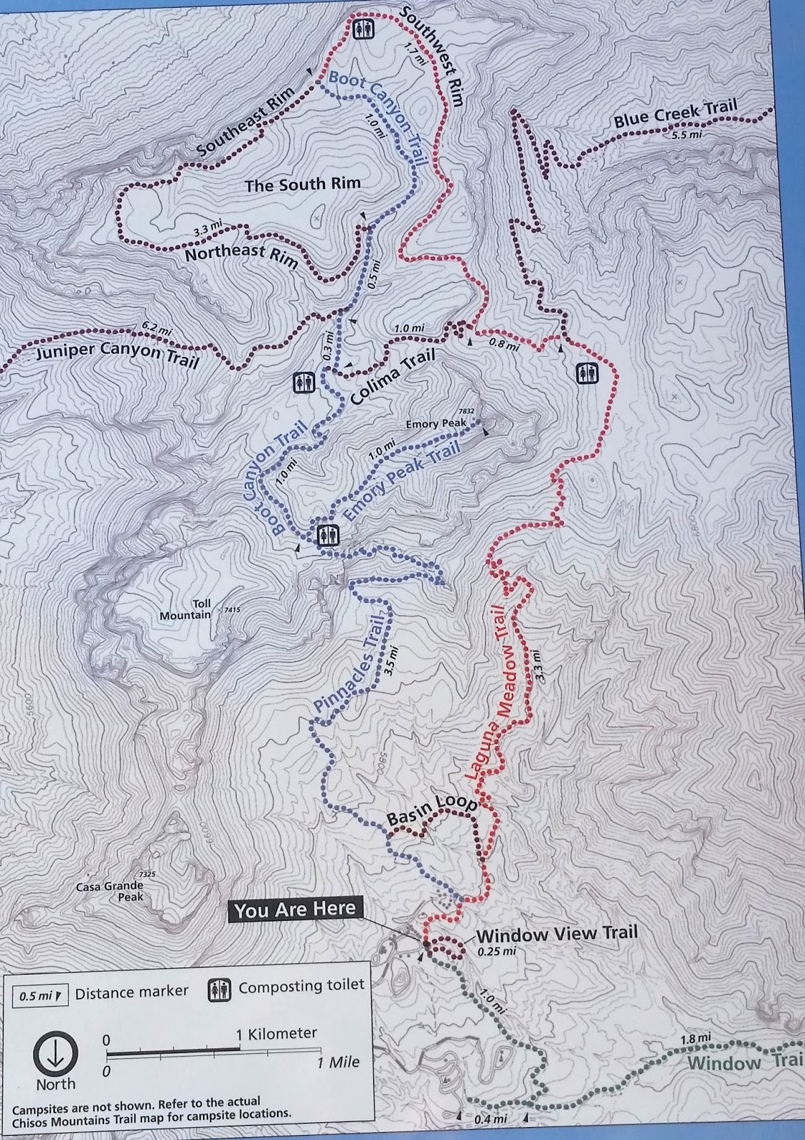
 276 RIO GRANDE National Scenic River, Big Bend National Park
277 BIG BEND National Park, TX
Including Big Bend National Park and the Rio Grande Wild & Scenic River, the National Park Service administers 245 miles of border - 13% of the entire United States-Mexico border. I entered the park at the Texas Hwy 118 entrance about 8:45 am and took an immediate right along Old Maverick Road. This is a 13 mile dirt road through the Chihuahua Desert to Rio Grande River and the Santa Elena Canyon.
 |
| Big Bend Timeline - the land was a gift from inidividuals to the US governement The deed was presented to FDR on June 6, 1944 |
Big Bend National Park /Rio Grande National Scenic River is unique in that it has three distinct ecologic areas – Desert, Mountain, River – resulting in an outstanding diversity of wildlife..
 |
| This map does not do the park justice. You can enter by road from the north or the west. A lot of wilderness and desert. |
There 5 Visitor Centers, Castolan Visitor Center, Chisos Mountains Visitor Center, Panther Junction Visitor, Rio Grande Visitor Center, and Persimmon Gap Visitor Center. I stopped at the first three today.
 |
| The Santa Elena Canyon is an impressive landmark while travelling the Old Maverick Road. The wall on the left is Mexico the right hand side and everything in front is the United States. |
 |
| Santa Elana Canyon Trailhead |
 Santa Elena Canyon
Trail – River Hike Difficulty: Moderate;
Distance: 1.7 miles round trip. The trail begins at terminus of the Ross Maxwell
Scenic Drive. Taking Old Maverick Road brought me here before
many other people who took the paved road.
This trail leads into the stunning Santa
Elena Canyon. I spotted the
canyon long before I arrived – it is stunning.
After crossing Terlingua Creek, the trail ascends on paved
stead ps to a vista, then descends back to the water's edge, continuing into the
canyon until the canyon walls meet the water. This ia a must hike. The trail is impassable when Terlingua
Creek floods. I started
at 0945 and finished at 1030.
Santa Elena Canyon
Trail – River Hike Difficulty: Moderate;
Distance: 1.7 miles round trip. The trail begins at terminus of the Ross Maxwell
Scenic Drive. Taking Old Maverick Road brought me here before
many other people who took the paved road.
This trail leads into the stunning Santa
Elena Canyon. I spotted the
canyon long before I arrived – it is stunning.
After crossing Terlingua Creek, the trail ascends on paved
stead ps to a vista, then descends back to the water's edge, continuing into the
canyon until the canyon walls meet the water. This ia a must hike. The trail is impassable when Terlingua
Creek floods. I started
at 0945 and finished at 1030. Dorgon-Sublett House Trail – Desert Hike this was an easy 1 mile round trip.
 |
| Dorgan-Sublett Trailhead |
 |
| James Sublett made this dry land into a thriving farm thanks to irrigation and the Rio Grande River |
 |
| Only the outline of the Sublett House remain - those cliffs are in Mexico |
Castolan Visitor Center & General Store this is also Rio Grande River access point for raft/canoe put in or take–out. Small contact station/visitor center – not open during the summer.
 |
| Castollan Store & Visitor Center |
 |
| Castollan Visitor Center |
 |
| Cerro Castellan - picture at the left |
 |
| Cerro Castellan form Castollan VC |
Tuff Canyon – Desert Hike Difficulty: Easy; Distance: They say it’s a ¾ mile round trip, but NPS does not tell where it begins or end. I think it’s more like 1+ miles round trip – the way I did it. Started at 1140 finished at 1215. Begins at Tuff Canyon overlook on the Ross Maxwell Scenic Drive. Tuff Canyon's three overlooks offer great views into Tuff Canyon, but you can continue on the trail at the south end of the parking lot to go down into the canyon. Tuff, made of welded volcanic ash, comprises this whitish canyon. During the rainy season, the canyon fills with pools of water.
 |
| Tuff Canyon looking down from the West Overlook |
 |
| Tuff Canyon - looking down from the East Overlook The black rock to the right is about 12-15 ft straight up - to me that was the end of the trail Adventurersome hikers can climb around the edges |
 |
| Tuff Canyon Trail Map |
Burro Mesa Pouroff Trail – Desert Hike Difficulty: Easy; Distance 1 mile round trip. The trail enters a dry wash and ends at the bottom of the Burro Pour Off. Lots of geology here – it would be great to see it flow.
 |
| Burro Mesa Pouroff Trail |
 |
| Burro Mesa Trail This is the PourOff and end of the trail |
 |
| Burro Mesa Trailhead |
 |
| Burro Mesa Trail Looks like another PourOff from the mesa |
 |
| The Chinos Mountains, as you drive around the park these become a familiar sight. The basin in in the middle of the mountains. This picture taken from the Ross Maxwell Scenic Drive. |
Chinos Basin Visitor Center – There is also a lodge here and small Visitor Center. I tried to make a reservation on-line yesterday – rooms looked available but of course the website wasn’t working and I had no phone service to call. Needless to say – by 2 pm all the rooms were gone for the evening. I’ll come back here tomorrow for some hiking in the mountains. There are mountain lions and black bears here.
 |
| Panther Junction VC |
Panther Junction Visitor Center. – this is the park headquarters and the largest VC so far. There was a good 30 minute video that highlighted the three ecosystems in the park – Mountain – River – Desert. It was 3:30 pm –time to head back to Alpine, TX.
THURSDAY March 24, 2016
 |
| Sunrise Santiago Peak EL 6521 along Texas Hwy 118 on the way to Big Bend |
BIG BEND NP TX Sunrise 0752 Sunset 2008; Moonrise 2122, Moonset 0835
TRAVEL: Alpine, TX to Big Bend NP/Rio Grande NSR to Alpine, TX still a 1 hour 40 minute drive to
the west entrance of the the park.
276 RIO GRANDE National Scenic River, Big Bend National Park
277 BIG BEND National Park, TX
 |
| Grapevine Hills Trail - map |
Grapevine Hills Trail – Desert Hike Difficulty: Easy, the last ¼ mile is a uphill rock climb; Distance: 2.2 miles round trip. The trail head is 6 miles down Grapevine Hills improved dirt road. Several rustic campsites are along the road – good for solitude. There is a small parking area at the trail head. The trail leads to a group of balanced rocks in the heart of the Grapevine Hills. Initially, the trail follows a gravel wash, then climbs steeply for the last quarter mile into the boulders. Grapevine Hills is an exposed laccolith, with many giant, rounded boulders that are tempting to climb, but you are warned to watch for snakes.
 |
| Balanced Rock End of the Trail |
 |
| Grapevine Hills Trail |
 |
| Under Balanced Rock |
 |
| Big Bend NP - Heading southwest on the Grapevine Hills Road - The Chisnos Mountains an island in the desert |
 The drives between points of interest in the park are long.
I entered the park at 0840 reached Grapevine Hills Road at 0900 and began
hiking at 0925. It took one hour to hike
the trail. It was clear, the sun was rising, windy and 52 degrees.
The drives between points of interest in the park are long.
I entered the park at 0840 reached Grapevine Hills Road at 0900 and began
hiking at 0925. It took one hour to hike
the trail. It was clear, the sun was rising, windy and 52 degrees.
After a short stop
at the Panther Junction Visitor Center , I headed north toward north entrance of the park
and Persimmon Gap Visitor Center. The road is paved and not much
to see along the 26 mile drive. I did stop at a Fossil Bone Exhibit. A new building is under construction and with
ever efficient government efficiency there was no construction going on – just
some heavy equipment and a foundation on the site.
 |
| Dog Canyon Trail - A Desert Hike I did not walk this. Dog Canyon must be in the distance. Looks like 1.9 miles one way. Take water. |
 |
| Persimmon Gap VC Closed for Lunch sign in the door This VC is only open in the "winter" |
I drove the 26 miles back to Panther Junction and headed another
20 miles southwest to the Rio
Grande Village Visitor Center - arrived at 1310 – the paved
roads in the park generally have a speed limit of 45 mph. The Visitor Center here was manned by two
volunteers.
 |
| Remember the brown south of the Rio Grande is Mexico |
 |
| Rio Grande Village Nature Trail - Wetland the water was refreshing after walking a lot of desert |
Rio Grande Village Nature Trail – River Hike Difficulty: Easy; Distance: I took two alternate routes to the river and came back to climb up to the overlook. – probably 1¼ miles It took 45 minutes to walk. The trail head is near Site #18 in the Rio Grande Village Campground. The layout is confusing to drive around in. The trail has interpretive numbered markers but of course there is no trial guide. The trail is very scenic. The first 100 yards is wheelchair accessible and crosses a boardwalk through a spring-fed wetland. Then the trail gradually climbs a limestone hill with panoramic vistas of the Rio Grande and the Chisos and Del Carmen Mountains. This trail would be great for a sunset walk..
 |
| The Rio Grande Mexico on the other side |
 |
| Rio Grande Village Nature Trail trail head |
 |
| Grinding hole The location of a spring and the river was a natural place for people to live |
 |
| Boquillos Crossing Station There is fencing at the building Port of Entry |
Boquillas Del Carmen is a Mexican Village on the other side of the Rio Grande. There is a crossing station – Port of Entry – no reason to visit so I stayed away.
Boquillas Canyon Trail - River Hike This is a 1½ mile round trip – moderate/easy trail with spectacular view of the Boquillas Canyon. It begins with a short climb then descends to a sandy side of the Rio Grande. Like the Tuff Canyon Trail yesterday, I walked until I thought I reached the end of the trail. A more adventurous person may have braved the steep, slippery rocks to continue.
 |
| Boquilloas Canyon Trail - that is Mexico looks like a wall to me |
 |
| Boquillos Canyon Trail head |
 |
| Boquillos Canyon Trail - the green was refreshing |
 |
| Hot Springs Trail - Ruins of the Spa |
 |
| Hot Springs Trail Trail head |
 |
| Hot Spring Trail Along the river |
Begin at Hot Springs
parking lot This trail passes the remains of the Langford
Resort, pictographs (never found them not marked), homestead, and
hot springs (not marked). There was no
brochure and I never really found the hot springs – it could have been the pool
along the river where 15 young people were romping. Supposedly, the 105°F springs are a popular
destination (0.5 mile roundtrip), but I continued to where the trail forks,
leading to the top of the bluff and back to the parking lot. This trail took about 45 minutes to walk.
 |
| Chinos Basin Window View Trail |
 |
| Chinos Basin Trails |
 |
| Big Bend - Window View Trail Chinos Mountains |
 |
| Mountain Islands in the Sky |
BIG BEND NATIONAL PARK can be a 1-5 day excursion. I saw just plenty in two days of hiking. Consider an overnight in the lodge at Chisos Basin or camp out at a remote site or at Rio Grande Village. A raft or canoe trip down the Rio Grande with an overnight is the real way to see the canyons – this is another two days. Most of the main connecting roads are paved – the dirt roads offer some adventure and in some cases the only way to reach a trail head. Another option is a long walk/overnight in the Chisos Basin.
FRIDAY March 25, 2016
WEATHER: cool 42 at 6 am, got up to a
pleasant 73 with wind
BIG BEND NP TX Sunrise
0751 Sunset 2007; Moonrise 2213, Moonset
0910
TRAVEL: stayed in Alpine, TX
GOOD FRIDAY

 Intended to read
and update the blog today. Only read one
chapter of “The Civil War in Arizona” and did update the blog – most
of the day was spent trying to fix the thermostat for the RV. I had some long distance assist from
Sturtevant but could not resolve the problem where a static discharge from my
finger appears to have shorted out the thermostat. The discharge made the AC and furnace both
come on at the same time. A temporary
fix of removing the fuse and turning the circuit breaker off solved the
problem. My concern is that the fuse for
the furnace (which I can do without) is also on the same circuit as the
refrigerator (which keeps the beer and meat cold). Time to clean the refrigerator out. I’ll
see an RV repair place in Del Rio, TX on Monday.
Intended to read
and update the blog today. Only read one
chapter of “The Civil War in Arizona” and did update the blog – most
of the day was spent trying to fix the thermostat for the RV. I had some long distance assist from
Sturtevant but could not resolve the problem where a static discharge from my
finger appears to have shorted out the thermostat. The discharge made the AC and furnace both
come on at the same time. A temporary
fix of removing the fuse and turning the circuit breaker off solved the
problem. My concern is that the fuse for
the furnace (which I can do without) is also on the same circuit as the
refrigerator (which keeps the beer and meat cold). Time to clean the refrigerator out. I’ll
see an RV repair place in Del Rio, TX on Monday.
SATURDAY March 26, 2016
WEATHER: 41 at 7 am clear and calm, partly
cloudy, got up to mid-70’s with some wind
ALPINE TX Sunrise 0748 Sunset 2009; Moonrise 2208, Moonset 0846
TRAVEL: Alpine, TX to Fort Davis NHS, Fort Davis, TX to Alpine,
TX
FORT DAVIS National Historic Site, Fort Davis, TX
 |
| Fort Davis Hiking Trails - worth the time to walk them |
Since Tuesday my plane had called for a return to Fort Davis to walk the trail. Today I left the RV Park and drove north the 25 miles to Fort Davis. I headed straight for the trail head the leads up to the Davis Mountains. There are three trails that all kind of blend together for a trip of almost 3 miles. The Tall Grass Loop starts just to the right of Officers Row. It winds its way up the Davis Mountains and connects with the North Ridge Trail or you can walk down to where you began. The North Ridge Trail will take you all the way to Davis Mountains State Park or connect with the Hospital Canyon Trail and end just behind the Fort Davis Hospital. It took me about 1¾ hours to walk the 3 miles including pictures and side trips to overlooks. Take water.
 |
| Fort Davis from the Overlook Enlisted Barracks left; officers row enter; Post Hospital far left foundations of kitchens and CO's private stable can be seen behind the homes. CPTs and above had their own homes. Married LTs shared a duplex arrangement. Single Officers usually had two rooms in a 2 story kind of apartment building. |
Named a Nature Trail it had more interpretive signs than all the trails I walked in Big Bend National Park. Along the top it reminded me of many volcanic trails in Hawaii without the tropical rain forest . . . . Take the time to walk this trail. It was well worth my re-visit.
 |
| Engleman Prickly Pear |
 |
| Older lava trail than Hawaii |
 |
| Old Lava formations - rhyolite |
SUNDAY March 27, 2016
EASTER
WEATHER: 37 degrees when I left Alpine at
1020 – clear – 66 in Del Rio at 1440 with some wind DEL RIO TX Sunrise 0736 Sunset 1958; Moonrise 2247, Moonset 0915
TRAVEL: Alpine, TX to Del
Rio, TX. Now I know where I may have heard of Alpine, TX before – a college town –
home of Sul Ross University/Big Bend University (Named for former Texas governor
and Civil War Confederate general Lawrence Sullivan Ross, it was founded in
1917 as Sul ). Passed it on
the way east, out-of-town, along US 90. The drive was 203 miles along US 90 – 3 hours
20 minutes. Passed the Judge
Roy Bean Museum (Law West of the Pecos) and the Pecos
River. The speed limit varied between 70 and 75 mph,
I maintained 65. Only passed by about 2
dozen cars in 203 miles and more than 10 were within 20 miles of Del
Rio.
 |
| Our Lady of Peace |

Broke Mill RV Park, Del Rio, TX WIFI Works – gravel site – level. Friendly owner, who also runs a ranch and has some of his beef for sale. I’m on the outskirts of Del Rio which a city of over 35,000. Laughlin AFB is NE of the city and it has a FamCamp – when planning I guess I didn’t put 2+2 together – this location is a little more expensive but closer to Amistad, saves drive time.
 |
| This sign is at the entrance to Diablo East boat ramp and marina |
Amistad National Recreation Area consists of the
US portion of the International Amistad
Reservoir. Amistad, whose name comes
from the Spanish word meaning friendship,
is best known for excellent water-based recreation, camping, hiking, rock art
viewing, and its rich cultural history. Amistad is also home to
a wide variety of plant and animal life above and below the water.
 |
| Amistad VC and Park HQ not much to brag home about |
Amistad NRA Visitor Center is located on US 90 about 6 miles west of Broke Back RV. There was no sign for the VC. Apparently a huge storm with golf ball size hail and huge winds, perhaps a tornado, hit here last week. The sign was blown down. There are several movies available for viewing. I’ll watch them later in the week.
Amistad is for boaters and
fishermen. There are 12 public boat
ramps with 540 miles of public shoreline in Texas. There are 750 miles of navigable river behind
the Amistad Dam. The international
boundary follows mid-channel.
 |
| Amistad Dam |
 |
| Friendship Memorial in the center of the dam I felt like I was trespassing. The Mexico Entrance Staion is about 100 yards to the left and the US Port of Entry was 2 miles to the right. Good thing I had my passport. I needed it to get back to the US. |
Construction
began in August of 1963 and was completed in 1968. The
National Park Service began
providing for and managing recreation at the Amistad Reservoir on November 11, 1965. I travelled across the dam to the center and
came back. The Visitor Center used to be
on the dam before 9/11 – when border security wasn’t such an issue. Good thing I had my passport to get back into
the US.
MONDAY March 28, 2016
WEATHER: 52 degrees at 6am – mostly cloudy; s/b 59 at
noon and reach a high of 69 by sunset. DEL RIO TX Sunrise 0734 Sunset 1958; Moonrise 2339, Moonset 0954
TRAVEL: Broke Mill RV Park to Amistad NSRA
278 AMISTAD National Recreation Area, Del Rio, TX
The
Amistad NRA area is home to dramatic 4,000 year-old rock
art. These mysterious paintings adorn rock shelter walls in the upper reaches
of Amistad Reservoir. Boaters can usually access Panther
and Parida Caves (depending on lake level), and hikers can go
on a guided tour at nearby Seminole
Canyon State Park and Historic Site.
 |
| Amistad National Recreation Area - boating and fishing - there are over 200 fishing tournaments a year on the reservoir Water is clear - up to 60 feet down so also a good place for SCUBA diving |
 |
| Pictographs - look to the right below |
 |
| A portion of the rock art |
I
watched two films at the VC today. Spirits of the Canyon is a 30-minute film that gives
insight into the Lower Pecos region
rock art. Window to the Past is also a 30 minute film that
describes Amistad National Recreation Area. Both
are PBS quality and worth viewing.
There is a lot of rock art in the area left by prehistoric
peoples. Little is known about them
because there is no recent tribe that has claimed this land as theirs. There is 25 foot long pictograph at Panther Cave left by a culture long
gone – a picture is in the VC because the site is only accessible by water. The entire area is full of rock art.
 |
| Diablo East Nature Trail Claret Cup Cactus |
 |
| These buoys mark the international boundary in the reservoir |
Diablo East has a small marina, boat ramp, fish cleaning station and a short Nature Trail.
I stopped by the RV dealer t query about the
thermostat. Unfortunately, there was no
way they could work on it before Wednesday.
I’ll see if I can get it fixed in Albuquerque when I travel east and
come home in April for 3 weeks. Perhaps,
I can avoid the storage.
TUESDAY March 29, 2016
WEATHER: 62 at 6 am cloudy; 70 at NOON; 78 at 5 pm with a steady wind
DEL RIO TX Sunrise 0736 Sunset 1959; Moonrise 0000, Moonset 1037
TRAVEL: Broke Mill RV to Amistad
NSRA to Langtry,
TX to Amistad to Broke Mill RV
 |
| Pecos River - US 90 Bridge |
278 AMISTAD National Recreation Area, Del Rio, TX
Unless you’re a
boater or a fisherman, there just isn’t a lot to do here.
 |
| Amistad -Pecos |
Pecos River is the last landing for Amistad NSRA although the NPS runs well past Langtry on the Rio Grande and up the Pecos River to Shumla Bend. Like I said fishing and boating.
There
is a short nature trail at Pecos. It is an easy walk and informative. There also was a set of stairs that goes down
the cliff..
 |
| Pecos River Trailhead |
 |
| Pecos River |
 |
| Pecos River |

JUDGE ROY BEAN MUSEUM, Langtry, Texas Pop 45
As long as I
drove to the Pecos River, I continued the drive to Langtry, TX and the Judge
Roy Bean Museum. As a kid, I recall watching a TV series,
called Judge Roy Bean – Law West of the Pecos . . . there was the Judge (a
rotund man with a short beard and a top
hat) and a girl – and of course bad guys . . . . don’t recall much more.
This
was worth the drive. If you are ever out
this way, for something other than boating or fishing take the time to visit
the Judge Roy Bean Museum. Allow an hour – the cactus garden walk alone
is worth the side trip – better than anything you’ll find in Armistad.
 |
| This is the original building |
 |
| Amistad - Sunrise Trail |
 |
| Amistad - Sunrise Trail Road is Spur 454 |
The Sunrise Trail is 2.5 miles
long round trip and connects the park Visitor Center with Spur 454.I
never got to the spur – the trail disappeared in green. Located on the old Brite Ranch, I saw a large variety of plants and birds while
hiking. IT was good to hear the birds
sing. I came across a small herd of deer
while on the trail. This is the only
trail worth walking at Amistad.
WEDNESDAY March 30, 2016
279 ALIBATES FLINT QUARRIES National Monument,
13,000
years ago this site was already well-known by mammoth hunters as a place to get
the best stone for their tools. Centuries passed but the colorful flint found
right here in the Texas panhandle never lost its value and usefulness.
 Although termed "flint,"
the stone is technically a silicified
or agatized dolomite occurring
in Permian-age outcroppings. These
deposits, exposed as slightly undulating layers, are unique to the Panhandle area. But regardless of what
the stone is called, none of the terms captures its startling beauty.
Although termed "flint,"
the stone is technically a silicified
or agatized dolomite occurring
in Permian-age outcroppings. These
deposits, exposed as slightly undulating layers, are unique to the Panhandle area. But regardless of what
the stone is called, none of the terms captures its startling beauty.

More than 700 quarries exist where this flint was dug out by hand. The quarries today are usually round ovals about six or more feet in diameter with depressions in the center. Wind and rain have filled the once four to eight foot deep holes with soil.
280 LAKE MEREDITH National Recreation Area
I
stopped by Harbor View and hiked the
Harbor Bay Loop – a hike of about 2.3
miles in about an hour and 10 minutes. The
Harbor Bay Trail system covers a
total distance of 5.2 miles. This is a bike/hike trail – rated as Advanced for
mountain bikers - never saw a bike track.
The terrain consists of a variety of gently rolling hills, steep slopes
with steps, and switchbacks. It is a moderate to hard hike that travels through
canyons and over mesas, with views of picturesque mesas, local foliage and Lake Meredith below. This was a refreshing walk.
Within
the dry and windswept high plains of the Texas
Panhandle
lies a hidden oasis, a welcoming haven where wildlife and humans find respite
from the dry grasslands above. Through this plain, the Canadian River has cut dramatic 200-foot canyons, or
breaks, where humans have eked out a living for over 13,000 years. Lake Meredith now occupies these hidden coves where early humans
once roamed.
 |
| Amarillo KOA Tin art - mariachi band |
WEATHER: 71 in Del Rio, TX at 5 am cloudy; 73 windy and clear in Amarillo at 5 pm
AMARILLO TX Sunrise 0733 Sunset 2006; Moonrise 0145, Moonset 1218
TRAVEL: Broke Mill RV Park, Del
Rio TX to Amarillo
KOA, Amarillo, TX; a trip of 500 miles – 8 hours 40 minutes – and an
uphill climb north getting only 8.7 mpg. I’m in the “high plains” - A long day
Amarillo KOA - What can I say - it’s a KOA, near a RR track and in the
flight path of the airport – and don't forget the sound of the highway - not many jets in and out of Amarillo but at least
you know you’re near civilization. . .
. . as expected the WIFI Works.
THURSDAY March 31, 2016
WEATHER: 35 at 6 am, clear, not a cloud in
the sky; 58 by 1:30 pm some clouds but mostly sunny. AMARILLO TX Sunrise 0735 Sunset 2008; Moonrise 0236, Moonset 1310
TRAVEL: Amarillo KOA to Alibates
Flint Quarries NM - Lake Meredith NRA to Amarillo KOA.
The Visitor Center for Lake Meredith is Alibates.
 |
| Alibates Flint Quarries - building in backgorund is the VC |
Alibates
(3 syllables Al–i–bates) has a small Visitor
Center
with museum and a 15 minute film.. The
ranger was very helpful. Since the
quarries are still considered an active archeological site, only guided tours
get you there. There were none scheduled
today.
A
local volunteer “flint knapper” is usually on site but not today
– I watched an interesting video on how this almost lost art fashions stone
tools out of the flint. .
 |
| Alibates Flint is unique because of its color and beauty. The edges when "knapped" are are charp as a razor blade. Alibates Flint is found hundreds of miles from here due to trading |
Archeological traces of
prehistoric Indians' homes, workshops, and campsites dot the entire Canadian River region of the Texas Panhandle, but few sites are as
dramatic as Alibates Flint Quarries.

The Alibates agatized/silicified,
dolomite, is distinctive for its many bright colors. This flint comes from
a 10-square-mile area around the monument, but most is concentrated on about 60
acres atop a mesa in the heart of the 1,000 acre monument.

More than 700 quarries exist where this flint was dug out by hand. The quarries today are usually round ovals about six or more feet in diameter with depressions in the center. Wind and rain have filled the once four to eight foot deep holes with soil.
Un-weathered flint was obtained by digging a foot or
more below the surface. The flint bearing
dolomite layers are up to eight feet
thick. Tools made from Alibates Flint
have been found in many places across the Great
Plains and Southwest. Its use
dates from 13,000 years ago to about 1870.
Between
1150 and 1450, people identified as the Plains Village
Indians,
ancestors of the Caddo, Pawnee and Wichita,
lived here in large permanent villages and smaller, outlying farming and
gathering communities. Villages were built of rock-slab houses from one to 100
rooms. Most were single-unit dwellings, although some rooms were connected.
Architecture of this period featured rectangular or semi-circular rooms with
funneled entranceways and stone enclosures. Environmental conditions, including
severe drought, coupled with encroachment from neighboring tribes from the West
likely drove these Indians out of the region by the end of the 15th century.
 |
| Lake Meredith (a remnant of what it used to be) National Recreation Area & Alibates Flint Quarries Look real close for what used to be the boundaries of Lake Meredith |
 |
| Lake Meredith - Harbor Bay |
Not much going on
here – not a boat on the Lake.
Since
1965, visitors to Lake Meredith National Recreation Area focused on the
lake and activities like boating and fishing. But over the last decade, the
lake has gradually shrunk due in part to drought conditions and water use in
the surrounding communities. This shows us just how important water resources
are to local inhabitants - including humans as well as wildlife and plant
communities.
 |
| Harbor Bay Trail - map |
 |
| This is the Harbor Bay Boat Launch - CLOSED I wonder how long its been since you could launch a boat here? |
 |
| Harbor View Trail |
 |
| Harbor View Trail Looking down on the trail |
 |
| Harbor View Trail Bay was once the bottom of Lake Meridith |
FRIDAY April 1, 2016
WEATHER: 35 at 6 am, cloudy
TRAVEL: Amarillo KOA to Alibates Flint Quarries
NM/Lake Meredith NRA to Fritch to Sanford to Borger to Panhandle to Amarillo KOA.
 NO FOOLING I went back to Alibates NM/Lake Meredith NRA to hike a trail at the end of a
road on the north side of the lake.
NO FOOLING I went back to Alibates NM/Lake Meredith NRA to hike a trail at the end of a
road on the north side of the lake. |
| Sanford Dam - that's the earthern dam in the background Low Water - What happened to the water? |
A last word
about Amarillo KOA – WIFI works during the week when it fills up on the weekend forget
about updating a blog – too slow.
279 ALIBATES FLINT QUARRIES National Monument,
280 LAKE MEREDITH National Recreation Area
 |
| This is where Lake Meredith used to be Plum Creek Landing - only the river in the background |
 Through the town of
Fritch and Sanford , across the dam to the Plum
Creek boat landing. The landing is closed, like Harbor
Bay, because the lake
level has dropped considerably since the 1960’s. The trail there was recommended by the ranger
I met on Thursday.
Through the town of
Fritch and Sanford , across the dam to the Plum
Creek boat landing. The landing is closed, like Harbor
Bay, because the lake
level has dropped considerably since the 1960’s. The trail there was recommended by the ranger
I met on Thursday.
But do think I
could find the trailhead? – NO . It did
find two horse camps and horse trails.
It is possible that the horse trails and hiking trail is the same . . . . .
but then I am not a horse and was not prepared to cross Lower
Plum Creek without waders –
easier for a horse. Just when I was
about to give Lake Meredith higher marks than Amistad for hiking . . . .
. of course they don’t have any maps of the trails. Well, the ranger was nice . Still haven’t seen a boat on the lake.
The highlight of
the day was finding NBS (Nuts, Bolts
& Supply) next to the True Value Hardware in Borger, TX a town of about 13,000. I found the absolute match for the screws I
needed for my grill for $1 – and 10x better service than Home
Depot.
I’ve seen all the NPS sites in Texas – my favorites
are Big Bend and Guadalupe
Mountains.- both NPs.- primarily because of their hiking
trails Big Bend is huge.
281 WASHITA BATTLEFIELD National Historic Site, Cheyenne, OK
 The
site protects and interprets the setting along the Washita (wash-i-taw) River where LTC George A. Custer led the 7th U.S.
Cavalry
on a surprise dawn attack against the Southern Cheyenne village of Peace
Chief Black Kettle on November 27, 1868. The attack
was an important event in the tragic clash of cultures of the Indian Wars era.
The
site protects and interprets the setting along the Washita (wash-i-taw) River where LTC George A. Custer led the 7th U.S.
Cavalry
on a surprise dawn attack against the Southern Cheyenne village of Peace
Chief Black Kettle on November 27, 1868. The attack
was an important event in the tragic clash of cultures of the Indian Wars era.
 29
AUG 1864 – In response to Evans’ proclamation
Chief Black Kettle has George Bent and others write letters to the Indian Agent
asking for a meeting.
29
AUG 1864 – In response to Evans’ proclamation
Chief Black Kettle has George Bent and others write letters to the Indian Agent
asking for a meeting.
 28
NOV 1864 – Chivington’s column moved up Big Sandy Creek.
Cheyenne Chiefs Black Kettle, Standing in
the Water
and White Antelope with Arapaho Chief Left Hand walked toward the mounted soldiers to parley. Cavalry crossed the creek firing into them
and the village. All be Black Kettle were killed or mortally wounded.
28
NOV 1864 – Chivington’s column moved up Big Sandy Creek.
Cheyenne Chiefs Black Kettle, Standing in
the Water
and White Antelope with Arapaho Chief Left Hand walked toward the mounted soldiers to parley. Cavalry crossed the creek firing into them
and the village. All be Black Kettle were killed or mortally wounded.
Traveling
through a foot of snow, the command reached the Washita
Valley
shortly after midnight on November 27
and took up positions near an Indian encampment.
Custer attacked at dawn. He watched from a knoll as while his men
drove the Cheyenne from their lodges barefoot and half clothed
and pursued them in all directions. Black Kettle was killed.
When firing ceased two hours later 30-60 Cheyenne lay dead in the
snow. Some escaped; 53 women and
children were captured. Some of these
soldiers and warriors will meet again at the Little Big Horn.
Custer ordered the burning of all the lodges, belongings
and killed 800 Cheyenne ponies. The
engagement at Black Kettle’s camp may have been different if
the larger encampments to the northeast had been closer.
SUNDAY April 3, 2016
As expected most
of the big rigs were gone when I returned to the RV park about 0930.
Read and rested most of the day – labeled yesterday’s pictures. As expected, the big rigs started to come in around 2 pm – overnighters - an unfriendly lot – they don’t even come out of their big rigs (of course there is nothing inviting about Elk Creek RV) -usually in a hurry to get someplace else and of course I can’t connect with WIFI. In all fairness – I did meet a guy at the end of the day from Janesville – heading back after wintering in Mesa, AZ. Even ‘tourists’ are more friendly. I’ll be glad to get to LETRA tomorrow I don’t expect WIFI but the people will be friendlier.
Lake Elmer Thomas Recreation Area (LETRA) – I’ve passed this
place many times on the way to the Plantation or Meers or Mount Scott but never drove down here. A pleasant surprise - - - WIFI that works –5x better tha Elk City RV - not many folks here – only drawback is a drive of about 8 miles from Main Post – but maybe that is actually good. General Store and Lodge not open Mondays and Tuesdays.
In late 1868,
General Philip Sheridan arrived in the area with the 7th
US Cavalry under LTC George
A. Custer, the 10th
Cavalry under COL Benjamin
Grierson, the 19th
Kansas Volunteers and the 6th US Infantry. The new post was soon staked out and
construction began on the permanent stone buildings in 1869 -70. The post was soon named Fort
Sill in honor of
General Joshua Sill who was killed on December 31, 1862 at the Battle of Stones
River during the
Civil War.
GOLF FORT SILL, OK – I’ve played here before in a very dry, 90+ degree heat at the end of the day – I was walking – I remember all the water coolers were empty – nice – taking care of soldiers . . . . . it was CLOSED on Monday and somehow just doesn't seem like the course I remember . . .
I drove to Meers and had a beer then drove to Medicine Park for a brew at the Old Plantation. The Old Plantation is habitable – new owners actually put some money into it. On the menu is a 22 oz sirloin for $22. The whole of Medicine Park looks more like a resort than a run-down, old, dirty, do I really want to stop here place - like it used to. Meers hasn’t changed.
Maybe – just maybe I’m far enough away from lights to see stars. . . . . too much light pollution from LETRA probably for security
282 CHICKASAW National Recreation Area, Sulphur, OK
I
found Sulphur Spings just a block down the road – it
does smell like sulphur – but people drink the water – it is very clear.
By
the late 1890’s settlers had built the town of Sulphur
Springs
around the fresh and mineral springs, with hotels and bath houses that promoted
the waters’ medicinal qualities.
Residents of the town and the Chickasaw and Choctaw nations, fearing the waters would suffer from
uncontrolled use, worked with government officials to find ways to save the
springs.
In
1906, it was expanded and renamed the Platt National
Park for Sen.
Orville Hitchcock Platt, sponsor of the legislation.
In
1976, Platt National Park, Arbuckle Recreation Area and additional
lands were combined to create this nearly 10,000 acre recreation area. The foresight of the Chickasaw nation in 1902 played a critical role in preserving
the springs and creeks. The park is
named in their honor.
Just behind the Nature Center were the Antelope & Buffalo Springs Trails – 1.2 mile round-trip. This was a pleasant walk – an employee/volunteer at the Nature Center gave me a map of the trails in the park – but only after I expressed interest in walking trails. The non-experience at the Chamber of Commerce almost caused me to give up any idea of hiking – I do not like walking any trail without a map or an idea of what to expect. A two hour plus drive to find a place CLOSED is not encouraging. It does not speak kindly of a visit to the location. This is a recreation area – The Platt Historic District is best described as a very well maintained urban park.
I did find a Chickasaw
Visitor Center with the NPS logo on the building but it must
be state or city run – the HQ for Chickasaw – well a nice
place for the Superintendent and staff but no NPS presence at the
desk or in the bookstore. It’s not even listed as park HQ on the Chickasaw
NRA brochure – guess there was no money to update
the brochure after the new HQ was built.
I finished
reading Trinity: The History of an Atomic Bomb National Historic
Landmark by Jim
Eckles, Trinity was the name given to
the site where the first atomic bomb was exploded. Eckles served as PAO for White
Sands Proving Ground. The site owned by the army is only once a year,
on the first Saturday in October. The
army will not release control to the National Park Service. An easy read; with some good science and
detail from primary sources.
SATURDAY April 2, 2016
WEATHER: 35 at 6 am clear, 71 in Oklahoma by afternoon
– pleasantly warm with the sun and of course some wind
TRAVEL: Amarillo, TX to Elk Creek RV Park - Elk City
OK to Washita Battlefield NHS to Elk
Creek RV Park
Elk Creek RV Park, Elk City, OK – what can I say about this place – it’s a RV Park
– probably the “best” there is within 50 miles.
Sites are gravel – I wasn’t told about the showers – bath house or
laundry when I checked in. WIFI – they claim to have it – but
don’t hold your breath you could suffocate before you connect – Lots of big
Class A and 5th wheel rigs checked in after I did – bet they’re gone
in the morning.
 |
| Washita NHS shares a building with the USFS Black Kettle National Grassland |
This was a piece of
history. A story that deserves to be
remembered and retold. It was a
“rehearsal” for the Little Bighorn – except at the Little Bighorn, the odds were against Custer and the Cheyenne along with the Lakota
Sioux got their revenge.
 The
site protects and interprets the setting along the Washita (wash-i-taw) River where LTC George A. Custer led the 7th U.S.
Cavalry
on a surprise dawn attack against the Southern Cheyenne village of Peace
Chief Black Kettle on November 27, 1868. The attack
was an important event in the tragic clash of cultures of the Indian Wars era.
The
site protects and interprets the setting along the Washita (wash-i-taw) River where LTC George A. Custer led the 7th U.S.
Cavalry
on a surprise dawn attack against the Southern Cheyenne village of Peace
Chief Black Kettle on November 27, 1868. The attack
was an important event in the tragic clash of cultures of the Indian Wars era.
BACKGROUND – A Setting For Tragedy
1851
– Treaty of Fort Laramie assigns to
tribes a large swath of the Great Plains and promises annuities. Tribes guarantee safe passage for settlers
along the Oregon Trail.
1858
– Gold is discovered in Colorado
1861
– Treaty of Fort Wise greatly reduces
1851 treaty lands.
11
AUG 1864 – Colorado Governor John Evans issues a
proclamation authorizing citizens “to
kill and destroy . . . hostile Indians.”

28
SEP 1864 – Cheyenne & Arapaho leaders,
including Black Kettle, meet with Gov Evans and
COL Chivington. They
are told to lay down their arms and turn themselves in at Fort Lyon, nothing else.
OCT
1864 – Evans writes “ winter
is the most favorable time for their chastisement.” The Cheyenne arrive at Fort Lyon and eventually to Sand
Creek. Black Kettle’s band is
there. The 700 people are mostly Cheyenne in 130 tipis..
NOV
1864 – COL Chivington leaves Fort Lyon with 675 men
and four 12 lb mountain howitzers. The
column heads for Sand Creek.
 28
NOV 1864 – Chivington’s column moved up Big Sandy Creek.
Cheyenne Chiefs Black Kettle, Standing in
the Water
and White Antelope with Arapaho Chief Left Hand walked toward the mounted soldiers to parley. Cavalry crossed the creek firing into them
and the village. All be Black Kettle were killed or mortally wounded.
28
NOV 1864 – Chivington’s column moved up Big Sandy Creek.
Cheyenne Chiefs Black Kettle, Standing in
the Water
and White Antelope with Arapaho Chief Left Hand walked toward the mounted soldiers to parley. Cavalry crossed the creek firing into them
and the village. All be Black Kettle were killed or mortally wounded.
COL
Chivington ordered the artillery to fire. As the soldiers scattered over many square
miles command and control were lost.
Many soldiers died in their own crossover.. When the firing was over,165-200 Cheyenne and Arapaho people were
killed – 2/3 of them women and children.
There were 100 fighting-age men in the camp who tried to form a line to
protect the women and children. Some
 soldiers looted, scalped and mutilated the dead. The Sand Creek
Massacre
is a National Historic Site in Colorado
that I plan to visit later this year.
soldiers looted, scalped and mutilated the dead. The Sand Creek
Massacre
is a National Historic Site in Colorado
that I plan to visit later this year.

1867
GEN Philip Sheridan took command of US forces in the
West proposing to bring peace to the Plains.
Following
the Sand Creek Massacre, Warrior
societies of mostly young men, opposed the reservation life. Many called themselves “dog soldiers.”. Sheridan adopted a policy of “punishment must follow crime.” MG Winfield S.
Hancock
begins a campaign against the Cheyenne and other
tribes rumored to be planning attacks on Kansas settlements and
trade routes.
WASHITA
Sheridan frustrated that traditional campaigning
methods failed to defeat the Plains warriors prepared for a winter campaign.
 |
| Batlle of Washita |
23
Nov 1868 LTC George A. Custer set out from Camp Supply in
Indian Territory with about 700 7th
US Cavalry
troopers. His objective was the Washita
River where about 6,000 Cheyenne, Arapaho, and Kiowa
had laid out their winter camps.
 |
| Battle of Washita mural in Visitor Center |
Custer divided hi command to encircle the village
and hit it on four sides. Coincidentally
this was the camp of Black Kettle who had survived Sand Creek.
 |
| Washita - map at trail head |
 |
| Washita Aftermath |
 |
| The Cheyenne & Arapaho camps to the east came to the aid of Black Kettle's Cheyennes - resulting in the a feint attack by Custer and the loss of MAJ Elliot and 17 soldiers. |
There
is a well marked 1½ mile trail on the site. A trail guide is
available for purchase from the Visitor Center. Several
laminated copies of the trail guide are also available for use at the trail
head. I walked the trail in my Ariat
western boots – no blisters – comfortable enough to walk in – a mild
surprise. The boots took on a lot of red
Oklahoma dust.
Today,
as in 1868, the Washita River flows silently through the
valley. The river banks are shaded by cottonwoods and sycamore and flanked with
waving fields of grass. Ancient hills of red dirt rim the horizons. This
peaceful setting offers us hallowed ground to contemplate this watershed event
in our shared history, a place to find understanding, meaning, and perhaps
healing in the wake of tragedy.
SUNDAY April 3, 2016
WEATHER: 35 at 6 am – it truly is coldest
before the dawn,
TRAVEL: Elk Creek RV Park
8 am Mass at
Our Lady of All Saints located in Sayre,
OK. The same priest covers St. Andrew’s
church in Elk City. The priest is
Indian. The gospel was about the
‘doubting Thomas.” The gospel allowed
the priest to focus his homily on Thomas’ travels and martyrdom in India. A young priest; with a congregation of about
50. After mass I was approached by a man
asking where I was from in WI – he was from Gilman, near Eau Claire. A friendly congregation.
 |
| Nothing Exciting about this place |
 |
| Route 66 Museum Elk City, Oklahoma |
Read and rested most of the day – labeled yesterday’s pictures. As expected, the big rigs started to come in around 2 pm – overnighters - an unfriendly lot – they don’t even come out of their big rigs (of course there is nothing inviting about Elk Creek RV) -usually in a hurry to get someplace else and of course I can’t connect with WIFI. In all fairness – I did meet a guy at the end of the day from Janesville – heading back after wintering in Mesa, AZ. Even ‘tourists’ are more friendly. I’ll be glad to get to LETRA tomorrow I don’t expect WIFI but the people will be friendlier.
MONDAY April 4, 2016
WEATHER: 49 at 5 am; clear got up to the
highs 80’s at Fort Sill, clear blue sky
TRAVEL: Elk Creek RV Park to Lake
Elmer Thomas Recreation Area (LETRA), Ft. Sill, OK I waved at
the coop in Apache, OK as I drove
to LETRA.
 |
| LETRA |
place many times on the way to the Plantation or Meers or Mount Scott but never drove down here. A pleasant surprise - - - WIFI that works –5x better tha Elk City RV - not many folks here – only drawback is a drive of about 8 miles from Main Post – but maybe that is actually good. General Store and Lodge not open Mondays and Tuesdays.
FORT SILL
 |
| This is the Old Corral The original fort. The gate is open bu the place is closed for renovation. With funding the way it is, look for it to re-open in the distant future. |
All four Black
regiments that were later referred to as the “Buffalo Soldiers”; the 9th and 10th
Cavalry and the 24th
and 25th Infantry served at Fort Sill during the late 19th
century.
Fort Sill’s
primary purpose was to control Commanche, Cheyenne, Kiowa and other tribes of the Southern Plains who were
making frequent raids on settlements in Texas and Mexico.
The museum was CLOSED
on Monday
The Visitor
Center was CLOSED on Monday.
The Old Corral
was CLOSED.
 |
| I first met LTG (Ret) David Valcourt when he was S3 of the 212 FA Bde I believe I was the S3 for the 1-121 FA . We were both Majors. He either commanded the first HIP (Howitzer Improvement Program) Battalion or Battery. HIP was this was the precursor to the Paladin. He served as G3 IIICA during the Gulf War but was not deployed. I was S3 of the 1-121 FA. Then his career took off like a meteor. Somewhere in that career he was Commanding Officer Ft. Sill. Why do I think he moved the golf course? or the clubhouse? |
GOLF FORT SILL, OK – I’ve played here before in a very dry, 90+ degree heat at the end of the day – I was walking – I remember all the water coolers were empty – nice – taking care of soldiers . . . . . it was CLOSED on Monday and somehow just doesn't seem like the course I remember . . .
 |
| Meers - that is not my truck parked in front - JUMBO Hamburgers |
 |
| Everything is BIG at Meers Known for HUGE hamburgers This was Meers Gold a tasty ice cold wheat beer |
 |
| The Old Plantation not like I remember it at all this place is clean and unforutnately they do not serve Busch - known for JUMBO steaks |
I drove to Meers and had a beer then drove to Medicine Park for a brew at the Old Plantation. The Old Plantation is habitable – new owners actually put some money into it. On the menu is a 22 oz sirloin for $22. The whole of Medicine Park looks more like a resort than a run-down, old, dirty, do I really want to stop here place - like it used to. Meers hasn’t changed.
Maybe – just maybe I’m far enough away from lights to see stars. . . . . too much light pollution from LETRA probably for security
TUESDAY April 5, 2016
WEATHER: 57 at 5am, clear – even with the
light pollution Scorpio is still brilliant in the southern sky; by 4 pm back to
Ft. Sill it was 87 and very windy – gusts 40-50 mph – it’s Oklahoma – the West
– to be expected
TRAVEL: LETRA to
Chickasaw NRA to LETRA
 |
| Everything I visited was in the Platt Historic District |
The
Visitor Information Center is co-located with
the Chamber of Commerce in Sulphur Springs, OK. Of course, when I got there at 9:20 am no one
had showed up to open at 9 am – not a NPS site.
 |
| Veldome Artesian Well Strong smell of sulphur Water is very clear |
 |
| Veldome Artesian Well (right) no longer goes 30 ft high |
Archeologists
believe that people have lived here for thousands of years. Ancient peoples believed in the healing power
of the strong-smelling mineral water, and tribes like the Wichita, Caddo and
others came here. In the early 1800’s,
the federal government began moving tribes from east of the Mississippi River - Choctaw, Chickasaw and others – to this area. In 1855, land that is now part of the NRA
came under control of the Chickasaw Nation.
 |
| Chickasaw National Recreation Area - Map of Platt Historic District |
 |
| Veterans Lake - there is a paved trail around the entire lake |
In
1902, when the Chickasaw and Choctaw nations sold
all the springs and 640 acres to the Department of
the Interior
to protect these resources, the area became Sulphur Springs Reservation.
 |
| Civilian Conservation Corps |
In
the 1930’s, the Civilian Conservation Corps built
pavilions, roads, trails and waterfalls, and planted over 500,000 trees. As I drove through the Platt Historic Area it reminded me of Whitnall Park – a near urban setting but with shelters, picnic
areas, trails, roads, dams and ponds all a result of the CCC – except here the
water is not muddy – it is very, very clear – spring fed.
 |
| Chickasaw Travertine Nature Center |
Springs,
streams, lakes-whatever it's form, water is the attraction at Chickasaw National Recreation
Area. Little Niagara and Rock Creek beckon waders
and swimmers. Relax in the coolness of shaded stream or take a dip in a
swimming hole. Veterans Lake calls anglers to test their skills. Lake of the Arbuckles provides excellent motor boating, skiing,
fishing and swimming. The lake is
actually a reservoir created by a dam.
I
found the Nature Center and this must be what the NPS
calls its Visitor Center. There were no
rangers here on duty but they must give children and group programs here as requested. I did watch a 7 minute film about the area.
 |
| Buffalo Springs Containment built by CCC |
 |
| Antelope & Buffalo Springs Trail |
 |
| Built by CCC Antelope Springs is above second waterfall in background |
Just behind the Nature Center were the Antelope & Buffalo Springs Trails – 1.2 mile round-trip. This was a pleasant walk – an employee/volunteer at the Nature Center gave me a map of the trails in the park – but only after I expressed interest in walking trails. The non-experience at the Chamber of Commerce almost caused me to give up any idea of hiking – I do not like walking any trail without a map or an idea of what to expect. A two hour plus drive to find a place CLOSED is not encouraging. It does not speak kindly of a visit to the location. This is a recreation area – The Platt Historic District is best described as a very well maintained urban park.
 |
| Chickasaw Visitor Center Park HQ - amonument ot itself |
That’s 2 strikes (Amistad
– Lake Meredith) and a foul tip (Chickasaw) against the NPS involvement in NRAs – maybe if I was a fisherman I’d
feel different.
I did stop at the new
Fort Sill Museum –I wonder why all the Crusader prints and paintings are
hanging in the latrine – somebody’s idea of a joke? – the old museum is still
open. However, the gift shop is only
open on Thursday. I didn’t even bother
going to Snow Hall. Even
the golf course didn’t seem right - Fort Sill just isn’t like I remember it. At least the PX, Commissary and Clothing
Sales are where I remember them to be.
I drove through Ratón Pass on I-25 into Colorado. Raton Pass is on the Santa Fe Trail along the Colorado-New Mexico border. It is a federally designated National Historic Landmark. Ratón is Spanish for "mouse."
283 CAPULIN VOLCANO National Monument, Capulin, NM
This
could be an easy 6-8 hour visit if you walk all the trails; or at least at half
day full day visit and bring a picnic lunch.
The Visitor Center
has
a short film and Nature walk. The
drive up to the crater rim will provide
spectacular views and short but sometimes steep walks on paved trails. Take your time and enjoy the surroundings.
The Lava
Flow Trail at the
base of the volcano is an unimproved, 1 mile loop that crosses one of the
volcano's lava flows. Pick up a trail guide at the visitor center to learn more
about Capulin's lava flows and features along the way.
284 FORT UNION National Monument, Watrous, NM
This was a little
more than a hour drive from Raton, NM.
Plan 2-3 hours for a visit and you’ll see just about all there is to see
– but there is more history here than I thought. When this was declared Fort
Union a NHS in 1954 something in the wording
said “preservation” – therefore, the NPS has not put any effort into “restoration”
of the fort or any of its buildings. I
had to ask the ranger because it just seemed odd – the NPS generally restores to as close
to original as possible.
Exposed
to the wind, within a sweeping valley of short grass prairie, amid the swales
of the Santa Fe Trail, lie the territorial-style adobe
remnants of the largest 19th century military fort in the region. For forty
years, 1851-1891, Fort Union functioned as an agent of political and
cultural change, whether desired or not, in New Mexico and throughout the
Southwest.
1st Fort Union
2nd Fort Union
Fort Union's second fort, a massive, bastioned earthwork constructed in 1861 and largely abandoned by the close of 1863, stands as a unique and important example of mid-nineteenth-century American military architecture. The fort is exceptional for several reasons: 1) it is integrally associated with the Battle of Glorieta Pass (March 26-28, 1862), a crucial western engagement of the Civil War. It ended Confederate incursions into the American Southwest. 2) it is the sole surviving earthen star fort erected west of the Mississippi River. 3) it is the most intact, least-disturbed Civil War-era bastioned earthen fort surviving anywhere within the United States today
3rd Fort Union
The
Third Fort Union (1862 - 1891) was built in the
traditional "territorial"
style, and was constructed using native resources such as clay, stone, and lumber. The walls were constructed of adobe brick that stood on stone foundations, and were coated with plaster fired in limekilns. They were adorned with red bricks brought to New Mexico along the Santa Fe Trail.
Fort Union stayed in operation until the arrival of the
Atchison, Topeka, and Santa Fe Railroad in 1879 slowly
put an end to the Santa Fe Trail. The railroad ended one era and
opened another in the Southwest. Fort Union lingered on for
another ten years, and as the buildings deteriorated the end was in sight. The
post, along with the trail, had outlived its usefulness.
FRIDAY April 8, 2016
Kirtland AFB Base Chapel – today was First Communion for eight children. Plenty of incense and a mass said by a priest
from Africa, a deacon, 3 boy servers, a 7 person choir to include baby grand
piano, bass, and 12 string guitar. The
homily was directed to the children but the priest was involved – easy to
listen to – as he reflected on the readings – “follow me”
WEDNESDAY April 6, 2016
WEATHER: 59 and windy almost decided not
to travel – glad I did – it wasn’t that bad – clear and sunny – in the 60’s; 71
when I got to Raton
TRAVEL: LETRA , Ft. Sill, OK to Raton KOA, Raton. I left at 7:45 am CDT – arrived 2:45 pm MDT;
gained an hour but a drive of 443 miles – 8 hours on the road. Raton EL 6680 – Lawton EL 1112 – a gain of over a mile in
elevation, against the wind - only 7.8 mpg pulling the trailer.
,
Ration KOA – WIF works, gravel sites, close to each other, typical KOA
 |
| Santa Fe Trail - originally a trade route to Mexico's city of Santa Fe not a route for immigrants and settlers. The Mountain Route through Raton Pass was more difficult but had more water and less hostile Indians. The Cimarron Route had less water and more potential for hostile Indian attack. |
 |
| Fisher's Peak - high point in Raton Pass - a landmark along the Santa Fe Trail |
I drove through Ratón Pass on I-25 into Colorado. Raton Pass is on the Santa Fe Trail along the Colorado-New Mexico border. It is a federally designated National Historic Landmark. Ratón is Spanish for "mouse."
THURSDAY April 7, 2016
WEATHER: 39 at 6am in Raton clear sky; it
was cloundy
TRAVEL: Raton KOA – Capulin
Volcano NM – Fort Union/Santa Fe Trail
NHS –Wagon Mound, NM
– Cimarron/Philmont Scout Ranch, NM - Raton KOA
 |
| NM sign at turnoff to Capulin Volcano National Monumnet |
 |
| Capulin Volcano's cinder cone in the background |
A
unique place of mountains, plains, and sky. Born of fire and forces continually
reshaping the earth’s surface, Capulin Volcano provides access
to nature’s most awe-inspiring work.
Capulin Volcano Trails
 |
| /The White Line is the road. The Black Circular Line in the Crater Rim Trail. The short Black Line is the Crater Vent Trail. On the lower left is the Lava Flow Trail. |
The Crater
Rim Trail is a
paved, 1 mile loop around the top of the volcano. It is moderately difficult
due to steep climbs and descents. Wayside exhibits with panoramic photographs
provide visitors information about the surrounding features in the Raton-Clayton Volcanic Field.
The Crater
Vent Trail is a
0.2 mile (one-way) trail leading to the bottom of the Capulin's crater. This trail is paved and has an elevation change
of 100 feet.
 |
| View west from rim of Capulin Crater On the horizon are the snow capped peaks of the Sangre de Christo Mountains - Home to ski areas near Taos, NM. Lava fields and older volcanoes surround Capulin. |
 |
| A Cinder Cone Volcano spouts ash and "bombs" from it's vent forming an ashen cone. Lava flows from vents near the base of the volcano.. Capulin Volcano is higher on one side due to the prevaling winds blowing the ash to one side. |
 |
| Lava Flow Trail with Capulin Volcano in the background |
 |
| Capulin's Vent and the bottom of the carter |
The Nature
Trail is adjacent
to the visitor center. It is a figure eight sidewalk trail that is handicap
accessible. Stops along the way describes plant life, geology,
and wildlife in this short walk around a volcanic "squeeze up."
The Boca
Trail is an
unimproved, 2 mile strenuous loop through the Boca area. This is the vent area at the base from which the
volcano's lava flows originated. The trail provides close up views of numerous
geologic features. I didn’t walk this
trail.
 |
| Fort Union Historical Marker |
 |
| Fort Union National Monument & Santa Fe National Historic Trail |
 |
| Just believe the sign- they say the Santa Fee Trail was here. |
When
New Mexico became United States territory after the U.S.- Mexican War, the army established garrisons in towns
scattered along the Rio Grande to protect the area's inhabitants and travel
routes. This arrangement proved unsatisfactory for a number of reasons, and in
April 1851, Lt. Col. Edwin V. Sumner, commanding
Military Department No. 9 (which included New Mexico Territory), was ordered
"to revise the whole system of defense" for the entire territory.
Among his first acts was to break up the scattered garrisons and relocate them
in posts closer to the Indians. He also moved his headquarters and supply depot
from Santa Fe, "that sink of vice and
extravagance," to a site near the Mountain and
Cimarron branches of the Santa Fe Trail, where he established Fort Union.
 |
| 1st Fort Union was built of wood at the base of the hills in the distance. NPS does not allow you to walk out there. |
Usually,
civilians employed by the Quartermaster Department built frontier posts, but Sumner
discharged these men and assigned the work to his soldiers. The result was what
one might expect from unskilled laborers.
The result was almost uninhabitable. It
quickly fell apart and into disarray. Despite
the dismal living conditions, the soldiers managed to live there for ten years,
and participated in several Indian campaigns. Civil
War
came in April 1861, and when news reached New Mexico things began to change...
 |
| 2nd Fort Union - the earthen Star Fort |
Situated
in the valley east of the first Fort Union, a massive earthen fortification began to take shape in July 1861. Earth
parapets formed a square with angles shaped like arrowheads shooting out 200
feet from each corner. Located in these star points were storehouses, company
barracks, and officers' quarters. The parapets supported firing platforms and
artillery emplacements. Four other angles served as curtains against enemy
fire. The structure resembled an eight-pointed
star.
Fort Union's second fort, a massive, bastioned earthwork constructed in 1861 and largely abandoned by the close of 1863, stands as a unique and important example of mid-nineteenth-century American military architecture. The fort is exceptional for several reasons: 1) it is integrally associated with the Battle of Glorieta Pass (March 26-28, 1862), a crucial western engagement of the Civil War. It ended Confederate incursions into the American Southwest. 2) it is the sole surviving earthen star fort erected west of the Mississippi River. 3) it is the most intact, least-disturbed Civil War-era bastioned earthen fort surviving anywhere within the United States today
 |
| Artist conception of the 3rd Fort Union. The Post was on the left. The Depot left rear.. The support and supply was everything to the right. |
 |
| Fort Union was the supply base for these army posts |
 |
| Fort Union ruins of Officers Row |
 |
| Fort Union ruins |
style, and was constructed using native resources such as clay, stone, and lumber. The walls were constructed of adobe brick that stood on stone foundations, and were coated with plaster fired in limekilns. They were adorned with red bricks brought to New Mexico along the Santa Fe Trail.
The
Post at Fort Union was made to accommodate four companies, both
cavalry and infantry; and the Fort Union Quartermaster
Depot
was equipped to supply all other New Mexico forts. As the central supply hub
for all New Mexico posts, the Fort Union depot was
larger than the Post, and it employed more men, mostly civilians.
 |
| Wagon Mound Historical Marke |
 |
| Wagon Mound New Mexico located just easst of present day I-25 |
After
its abandonment in 1891 the once majestic buildings fell into ruins and faded
into the pages of history. Fort Union National
Monument
was established in 1956, after a group called Fort Union Inc., and others,
advocated for its protection and preservation. Today, the Fort Union ruins
stand as a reminder of its unique history and the vital role it played in the
development of the Southwest.
 |
| Philmont Scout Ranch Historical Marker |
 |
| St. James Hotel Cimarron, NM worth a stop |
 |
| Philmont's Trademark "The Tooth of Time" |
FRIDAY April 8, 2016
WEATHER: 39 and still at 6 am – cloudy
most of the day – some rain driving through Santa Fe – mid 60’s in Albuquerque.
TRAVEL: Raton KOA, Raton, NM to
Albuquerque KOA, Albuquerque, NM. A 4
hour drive..
Albuquerque KOA – better than the average KOA. WIFI works, paved and level sites, paved roads, several bath houses –
large 170 sites. Depending on the site,
some shade from small trees. This KOA has won the KOA
President and Founder’s
Award but they don’t
brag about it – and they deserve it. A
simple reproduction of the logos on their brochure.
I drove to Kirtland
AFB with the
potential of moving there . . . .
however, even at $18/day – I don’t think so. Unbelievable, but the KOA is 10x better. And I know the WIFI
works at the KOA – at the FamCamp it will be slow – unable to load
pictures on the blog. This FamCamp and
the base itself is nowhere near the quality of
Davis-Monthan’s Agave Gulch FamCamp.
Kirtland is home to Sandia National Laboratories. Most of
what I drove through today is Sandia. There
is a nice BX and Commissary. The Tijeras
Arroyo Golf Course is quite a
drive east of the base and labs but it has green fairways – looks a lot better
than Fort Sill.
I read a
pamphlet entitled Santa FeTrail National
Historic Trail published by the Western National Parks
Association.
SATURDAY April 9, 2016
WEATHER: 45 at 5 am, it rained for at least 4 hours
last night. This was the first dew on
the truck and trailer since I was in San Diego.
I washed down the truck and trailer with a squeegee and towel before I
left for the day. Cloudy – puddles on the
road – light rain-heavy fog - driving through Santa Fe – cleared up to partly cloudy
and mid-60’s by afternoon
TRAVEL: Albuquerque KOA – PECOS
NHP (Glorietta Pass) – Bandelier NHS – Albuquerque KOA.
Pecos is just north of Santa Fe just off I-25; a 1 ¾ hour drive. Bandelier is about 70 miles from Pecos a good
1 ½ drive. It was 2 ¼ hours back to
Albuquerque.
285 PECOS National Historic Park, Santa Fe County, NM
A
visit here is worth a 3-4 hour visit.
The Pecos Pueblo Trail is paved, well
marked and takes about an hour. There is
a short movie narrated by Greer Garson in the Visitor Center, as well as, a small museum and
bookstore. The drive to the Glorietta Pass Trailhead is about 15
minutes from the VC and you need the combination to the lock in
order to enter the gate.
In
the midst of piñon, juniper, and ponderosa pine woodlands in the Sangre de
Cristo Mountains not far from Santa Fe, the remains of Indian pueblos stand as
meaningful reminders of people who once prevailed here. Now Pecos National Historical Park demonstrates to modern visitors the cultural exchange and geographic
facets central to the rich history of the Pecos Valley.
There is a one mile
paved trail that winds through the Pecos Pueblo.
Prior to my visit here I had no idea what this park all about or that a
sizable pueblo housing over 2,000 people was built here.
Pecos Pueblo became a regional power whose 2,000 inhabitants could muster 500
fighting men. The Pueblo was enclosed by a wall.
Like other Pueblo groups the Pecos enjoyed a rich cultural tradition
with inventive architecture and beautiful crafts. They had to be vigilant with nomadic Plains
Indians, whose intent –
trade or war – was not always clear. The
Spanish learned that the Pecos could be determined enemies or
powerful allies.
Spanish Franciscans built a mission complex. The first church was huge. It could house almost the entire population
of the pueblo. Decades of Spanish demands and Indian resentments
climaxed in the Pueblo Revolt of 1680. Indians from scattered pueblos
united to drive the Spanish out. The first church was destroyed.
Twelve years later
the Spanish returned and were
welcomed by the Pecos. A smaller church was built on the site of the
old.
The Pueblo declined in stature and was
almost a ghost town when the Santa Fe Trail trade began flowing past it in
1821.
Battle of Glorieta Pass
I had signed up for a two-hour, ranger
guided van tour relating the Battle of Glorieta Pass. They
need 3 in order to schedule the tour. On
Thursday I was the only one, by Saturday I was still the only one. Probably, good that it was cancelled I walked
the 2 ½ mile Glorieta Pass Trail.
Brig.
Gen. Henry H. Sibley's brigade
marched north from Fort Bliss in
January 1862, aiming for Albuquerque,
Santa Fe, Fort Union, and eventually Denver.
By March 5 the Confederate Army had
taken the capital of Santa Fe. Only Fort Union stood between them and
Denver. Soldiers from Fort Union joined forces with New Mexico and Colorado Volunteers, and headed south to meet the Confederate
Army at Glorietta.
The
Battle of Glorieta Pass, fought from
March 26-28, 1862, was the decisive battle in the New Mexico Campaign during
the Civil War in the West. Union forces, under the command of Col. John P. Slough, 1st Colorado
Volunteers, and under the direction of Maj. John M. Chivington, 1st Colorado Volunteers, successfully defeated
the Confederate forces. With the loss of
Sibley's supply train went the "grand design for the Confederacy in
the West." The Battle of Glorieta
Pass had successfully eliminated the Confederate threat in the western
territories.
286 BANDELIER National Monument, Los Alamos, NM
Driving into Frijoles
Canyon gave me an awe
inspiring feeling - similar to what I experienced when I first visited Yosemite
Valley. Bandelier is not Yosemite,
but it appears to
be able to draw crowds. I was surprised
to see so many people at 3 in the afternoon – it was a Saturday.
There is s short
video, museum, bookstore, gift shop and snack bar at the
Visitor Center. Allow 2 hours for a visit, unless you decide to walk some of the trails up the
canyon .
There was no road
into Frijoles Canyon until the mid 1930s when the Civilian Conservation Corps (CCC)
built one along with trails, the visitor center and lodge.
Bandelier National Monument protects over
33,000 acres of rugged but beautiful canyon and mesa country as well as
evidence of a human presence here going back over 11,000 years. There are
70 miles of trails. Petroglyphs, dwellings
carved into the soft rock cliffs, and standing masonry walls pay tribute to the
early days of a culture that still survives in the surrounding communities.
In
the 70’s the term Anasazi was a popular term to give to the people who lived
in these cliff dwellings. Now it appears
that Anasazi is not politically
correct – now they are called Ancestral Pueblo People. Somehow, that outdated term has a Navajo
origin, roughly translated as “ancient enemies”. Therefore, the term is no longer used.
Main Loop Trail
I purchased a Trail Guide for $1. The trail is a 1 ½ mile loop, with 21 numbered stops. It took just about an hour to walk it. The route is generally paved to the remains of the Tyuony Pueblo. Inclines and stairs lead to the Talus House Cliff Dwellings and the Long House Cliff Dwellings. After crossing Frijoles Creek, Spanish for “little river of beans”, there is a Nature Trail that leads back to the Visitor Center. You need the trail guide to understand what you are looking at. This park like Washita and Pecos had trail guides for use and return – you don’t have to buy one.
I purchased a Trail Guide for $1. The trail is a 1 ½ mile loop, with 21 numbered stops. It took just about an hour to walk it. The route is generally paved to the remains of the Tyuony Pueblo. Inclines and stairs lead to the Talus House Cliff Dwellings and the Long House Cliff Dwellings. After crossing Frijoles Creek, Spanish for “little river of beans”, there is a Nature Trail that leads back to the Visitor Center. You need the trail guide to understand what you are looking at. This park like Washita and Pecos had trail guides for use and return – you don’t have to buy one.
This
trail is part of a ranger guided tour mid-May through mid-October, daily at
10:30 and 2:00.
SUNDAY April 10, 2016
WEATHER: upper 40’s at 6 am; 50’s with the sun was warm – clear - then it clouded up by 3 pm in the high 60’s
TRAVEL: Albuquerque KOA – Kirtland AFB – Albuquerque KOA
 |
| Kirtland AFB Chapel |
I had planned to
golf this afternoon but I have a back problem similar to what I experienced in
October 2015 when I was in Washington, DC – except this is not debilitating. At least I can sit down – sitting aggravates
the back – but I don’t have a standup
desk in the trailer. There may be some
benefit to that . . . . . standup desk. In the meantime, a pillow in the small of the
back offers some comfort. It got cool
and cloudy with some drizzle anyway.
Maybe golf on Tuesday.
I read a little,
updated the blog and titled pictures.
Still have 125 pictures from yesterday to label.
s
MONDAY April 11, 2016
WEATHER: 42 at 5 am in Alburquerque, 42 in Valles Caldera at 1030 am got up to the mid 60’s clear and sunny in Albuquerque
TRAVEL: Albuquerque KOA through Bandelier
NM to Valles
Caldera National Preserve and back to Albuquerque following the NM Hwy 4 loop on the way back.
I forgot to take
my phone/camera and literature regarding Bandelier.
There was a threat of rain and time
. . . . I did not re-visit Bandelier VC but drove through a lot more of Bandelier
in order to get
to Valles Caldera National Preserve. One benefit – no pictures to edit and label.
286 BANDELIER National Monument, Los Alamos, NM
Nothing has been
said about this place’s namesake. Adolph
F.A. Bandelier was a self-taught
anthropologist and historian. He came to
the New Mexico Territory in 1880, sponsored by the Archeological
Institute of America.
Bandelier was guided by men
from Cochiti Pueblo to their ancestral homes in Frijoles Canyon in 1880. He spent 18 months in the field and visited
166 archeological sites. Bandelier’s pioneering work is relatively
unknown but it established a foundation for much of southwestern
archeology. Dr.
Edgar Lee Hewett, a prominent
southwestern archeologist, directed several excavations in Frijoles
Canyon in the early
1900s. He was instrumental in getting Bandelier
National Monument established in
1916.
287 VALLES CALDERA National Preserve, Jemez Springs, NM
Entering Valles Caldera is another awe inspiring experience,
after a winding uphill drive along NM Hwy 4 you suddenly break out into a large
flat valley grassland. This was formed
when the dome of the volcano sunk-deflated.
It is surrounded by volcanic domes.
Quite a view for the eyes..
About 1.25 million years ago, a spectacular volcanic eruption
created the 13-mile wide circular depression now known as the Valles Caldera. The preserve is
known for its huge mountain meadows, abundant wildlife, and meandering streams.
The area also preserves the homeland of ancestral native peoples and embraces a
rich ranching history.
The Visitor Center
is nothing more than a small Contact
Station – NPS just took over the
property last year October. The ranger I
spoke with has only been there two weeks.
Here’s some
background: The Valles Caldera Trust, a wholly owned government corporation, was
created by the Valles Caldera
Preservation Act of 2000. The trust,
governed by a nine member Board of Trustees, was described as an experiment in
public land management. It was
established as a demonstration area which incorporated elements of public and
private administration. The land changed
hands October 1, 2015 when the National
Park Service took over. There is a contact station but no “approved”
brochure.
The Valles Caldera started as the historic Baca Ranch, nestled in the Jemez Mountains. For years, the
stunning landscape was private land. The
National Park Service wants to make
the area even more accessible.
I walked the 1 mile La Jara Trail around a large volcanic
dome “squeeze” behind the Contact
Station. Refreshing, quiet, no cars,
no people, no wind, just me in the middle of this awesome meadow surrounded by
mountains . . . . . it was cloudy – the
long grasses were still bent from the winter snows. There was still snow in some places.
The roads past the Contact Station do not open until May
15th. Then only the first 35
cars are allowed to travel them daily.
If you were regular to
the area, there will be a savings in cost. In seasons past, a visit to the
trust could hit your wallet hard. It was
somewhat of an a la carte system. Each
activity cost $10 per day per person. A
family of 4 spending 2 days in the park would be charged $80.
Even before the switch
to the National Park Service, Valles Caldera changed the fee system.
Now, a family can get into the caldera for $20. That’s pays for one vehicle and
it’s good for up to seven days.
One of the biggest
challenges for the new site is infrastructure, which includes narrow,
unimproved, dirt roads. There is also a need for more parking areas, toilet
facilities and trail expansion. If you
visit Bandelier – you should visit
here. Unless you have a pass, each has
an entry fee of $20 per carload.