SUNDAY May 1, 2016
WEATHER: Left MKE 0710 CDT 48 degrees, arrived in Albuquerque via
Atlanta at 1235 MDT 50 degrees, cloudy and wind at 25 mph – it was cold and
rained around 6pm
TRAVEL: MKE-ATL-ABQ, picked up truck. A fantastic rate of only $42.75 at Park &
shuttle for 17 days. Checked into the Holiday Inn Express – Airport – Kirtland
AFB lodging was full.

288 PETROGLYPH National Monument, 6510 Western Trail,
Albuquerque, NM
I have visited Petroglyph National Monument in the past and walked the
Rinconda Canyon Trail. I arrived here around 2:30 pm and watched a
25 minute video produced in 2014. There
is a small bookstore. The museum is the
monument itself.
This is high desert – a mile above sea level – with
the City of Albuquerque on the boundary
of the monument. The Ancestral Pueblo people
discovered that chipping away at the thin desert varnish revealed a lighter
gray beneath and left a lasting mark.
Archeologists estimate that most of the images were made 400-700 years
ago. Some may be 2,000-3,000 years old.

Beginning in the 1600’s Hispanic heirs of the Atrisco Land Grant
carved crosses and livestock brands into the rocks. No one really knows what these images mean or
why they were created. Were the stone
bowls, “grinding slicks”,. used to
process plants and ritual medicines? Do
the spirals represent calendars, cycles of life? Are the representations of
human faces guarding sacred places?
Only the carvers knew what messages they were conveying.

There are 4 areas in the monument with trails. With limited time I went to Boca Canyon and walked the Mesa Point Trail. Boca Canyon is the most visited portion of
the monument although it contains only 5 % of the petroglyphs in the national
monument. There were interpretive signs
along the 30 minute walk up the side of the mesa.
Petroglyph National Monument was originally
established in 1973 as Indian Petroglyph State Park. Petroglyph
National Monument
was established in 1990. Ir features
more than 25,000 petroglyph images carved into the rock surfaces of the
volcanic cliffs of the West Mesa escarpment near Albuquerque.
 |
| Mesa Point Trail |
 |
Mesa Point Trail |
 |
| Mesa Point Trail and yes Albuquerque is that close. In the distance are the Sandia Mountains. Which were an uplift to the east |
 |
| Mesa Point Trail - Escarpement and Extinct Volcanoes in the background. The geology of the Albuquerque area is interesting |
MONDAY May 2, 2016
WEATHER: 38 degrees at 5 am, partly cloudy
with a high of 63
TRAVEL: a trip of 65 miles one way southeast of
Albuquerque, NM; back to Albuquerque KOA
 |
| Sign outside of VC & HQ in Mountainair, NM |
289 SALINAS PUEBLO MISSIONS National Monument, 105 S Ripley,
Mountainair, NM
There are three sites here that offer a glimpse into
a unique time in history. A time entrenched with cultural borrowing, conflict,
and struggles. The now abandoned sites stand as reminders of the Spanish and
Pueblo People’s early encounters.
Once, thriving trade
communities of Tiwa and Tompiro speaking Puebloans inhabited
this remote frontier area of central New Mexico. Early in the 17th-century
Spanish Franciscans found the area
ripe for their missionary efforts. However, by the late 1670s the entire Salinas District, as the Spanish had
named it, was depopulated of both Puebloans and Spaniards.
What remains today are
austere yet beautiful reminders of this earliest contact between Pueblo Indians
and Spanish Colonials: the ruins of four mission churches at Quarai, and the partially excavated
pueblo of Las Humanas or, as it is
known today, Gran Quivira. The third pueblo is called Abo.
 |
| Yes that is snow on the gournd Actually with a temp of mid 40's sun and no wind - it was very pleasant in a long sleeved t-shirt. |
 I
first stopped at the Salinas Pueblo Missions Visitor Center
and Headquarters located in Mountainair, NM a town of about 1,900. There is a small museum, bookstore and a 25 minute video. A snowfall last night was still evident by
snow on the roofs of some buildings.
Temp was about 43 – no wind – some clouds.
I
first stopped at the Salinas Pueblo Missions Visitor Center
and Headquarters located in Mountainair, NM a town of about 1,900. There is a small museum, bookstore and a 25 minute video. A snowfall last night was still evident by
snow on the roofs of some buildings.
Temp was about 43 – no wind – some clouds.
Quarai is an 8 mile drive northeast of
Moutainair. There is a contact station –small
museum bookstore and paved trails here. Plenty
of snow still on the trees.
The
hills at this site are actually the remains of a large masonry village or
pueblo. A few scattered walls above
ground are the result of limited excavations in the 1950s. It is believed that the population of this
pueblo were around 400-600 people.
 |
| Exploting Quari Trail Map |
 |
| A Square Kiva in the midst of the Convento. Square is unique. Location perhaps suggests a melding or toleration of ancient practice with the Catholic Church |
 |
| Church & Convento of Nuestra Senora de la Pruisma de Quarai - yes that is snow |

 Gran Quivira (Las
Humanas) is 25 miles southeast of Mountainair. There is a contact station – small museum - bookstore and paved trails. This appears
to be the largest excavation of the sites.
Unique to this location is dry farming – and living – no water source
such as a river or spring.
Gran Quivira (Las
Humanas) is 25 miles southeast of Mountainair. There is a contact station – small museum - bookstore and paved trails. This appears
to be the largest excavation of the sites.
Unique to this location is dry farming – and living – no water source
such as a river or spring. |
| Gran Quivira - aerial view. The large structure upper right is the church. Round structures are kivas. |

 Abo is 9 miles southwest of Moutainair on US
60. There is a contact station – small
museum bookstore and paved trails.
Abo is 9 miles southwest of Moutainair on US
60. There is a contact station – small
museum bookstore and paved trails. 
 |
| When a LT of the US Army explored this land he wondered at the people who lived here |
 |
| Artist depiction of Mission of San Gregorio de Abo |
 |
| Here at Abo also a Kiva on the church grounds |
 |
| Where did all the people go? Note that that it is supposed the the inhabitants of Gran Quivira and Quarai made their way to Abo and all eventually moved south - probably due to a prolonged drought |
Albuquerque Central KOA – still the best KOA I’ve ever visited – paved sites, very clean, neat, ample space
TUESDAY May 3, 2016
WEATHER: 47 degrees at 5 am
TRAVEL: a trip of 1 ½ hours to El Malpais then
another 40 minutes to El Morro - west of Albuquerque, NM
 |
| El Malpais Visitor Center It was previously called the Northwest New Mexico Visitor Center. A very nice facility. |
290 EL MALPAIS National Monument, Grants, NM
This
is a unique place. Mostly wilderness,
managed in conjunction with the Bureau of Land Management (BLM).
The Main Visitor Center is just south
of Grants, NM on Exit 85. There is a
small Information Center on Ice Caves Road (NM 53); a BLM ranger
station is south of I-40 on NM 117.
On December 31, 1987, Public Law
100-225 established El Malpais National Monument
and El Malpais National Conservation Area in the State of New Mexico. The Act
set aside for the benefit and enjoyment of future generations nationally
significant features, such as the Grants Lava Flow,
Las
Ventanas Chacoan Archeological Site,
Perpetual
Ice Caves, and other
prominent natural and cultural resources.
 |
| This is a big place. "You are here" is the BLM Ranger Station. El Morro is the western edge. |
The bill provided for 376,000
acres--262,000 as a national conservation area managed by the Bureau of Land Management and 114,000 acres as a national monument
administered by the National Park Service.
Conquistadors
dubbed it El Malpais meaning in Spanish
"the bad country." And it
was malpais--a mass of jagged,
jumbled, coal-black rock. The early travelers tried to avoid it. Most roads
simply skirted the lava flows. Trails, however, succeeded in slicing through
them. Indians living in the area, Acomas and Zunis, forged a footpath through the malpais connecting the two pueblos and
forming one of the oldest highways in the region. For the Spaniards, the malpais represented a formidable
obstacle. Their horses could not negotiate the razor-like lava without
lacerating hooves and fetlocks. The Spanish found it necessary to circumvent
the malpais traveling either
north via the Rio San Jose corridor or angling south, traversing the chain of extinct volcanoes on
the west side of the lava flows.
A visit to the El
Malpais VC took about 1 ½
hours to view an 8 minute video on El Malpais, a 25 minute film on El
Morro, and a 25 minute
film on the geology of northwest New Mexico.
All were worth while viewing.
There is also a museum. You could
spend days here or try to overachieve like I did, by visiting El
Morro & El
Malpais all in one
day. There is a lot of territory to
cover – most is wilderness – no roads – it is “bad country.”
After viewing the
videos I decided to drive to El Morro National Monument passing the El
Malpais Information Center on the way on NM 53. .
 |
| El Morro Visitor Center. To the right of the the walk is a large sandstone where you can try your hand at carving an inscription. Nice idea - but it is time for the NPS to replace the sandstone. |
290 EL MORRO National Monument, Ramah, NM
 I had planned to
visit here when I moved the trailer to
Gallup, NM but after seeing the video and the ranger at El
Malpais referring to El
Morro as a “sister park”
and seeing how close (relatively) it was I decided to drive here today. Perhaps a little more than can be expected
for a full day.
I had planned to
visit here when I moved the trailer to
Gallup, NM but after seeing the video and the ranger at El
Malpais referring to El
Morro as a “sister park”
and seeing how close (relatively) it was I decided to drive here today. Perhaps a little more than can be expected
for a full day.
Getting to El
Morro on NM 53 takes you
across the Continental Divide at EL 7882.
 |
| Inscription Trail - Petroglyphs |
Plan about 3 hours
at El Morro to walk the trails
and visit the museum.
El Morro (the headland) also called “Inscription Rock”
was a favorite place for Zunis and
Spanish and Americans to write into the rock. Geological forces of wind and rain will dismantle these carvings over time but now they hold stories.
The area was a
location setting for the 1948 western movie entitled “Four
Faces West” starring Joel
McCrea, Frances, Dee, and Charles Bickford.
 |
| Headland Trail on top of El Morro Zuni Sandstone & darker Dakota Sandstone |
El Morro is a cuesta, a long formation gently sloping upward, then
abruptly dropping off at one end. The
land is made of sandstone layers deposited by wind, desert streams, and an
ancient sea. A ranger indicated the the
bleached sandstone at the top of the formation is Zuni
Sandstone; the darker is Dakota
Sandstone.
 |
| El Morro Inscription Trail The pool of water |
Travelers on an
ancient trade route relied on El Morro’s source of water, a pool of runoff and of
snowmelt. Resting in the shade of the
bluff, they added their messages to the rock.
 |
| Overland Trail - Excavated portion of the Atsinna Puelbo |
The northeast
corner of Atsinna Pueblo was unearthed by archeologists in the 1950’s. The pueblo was abandoned around 1400 as
people moved to larger, consolidated villages in the Zuni
Valley. The Zuni, descendents of the Ancient
Pueblo people, live today in
western New Mexico.
I walked the ½ mile “Inscription Trail” – a paved trail with intermittent slopes that has a Trail Guide with 22
numbered stops. This takes about 45
minutes to walk. It is paved - mostly wheel chair accessible.
 |
| El Morro - Headland Trail going up |
 |
| El Morro - Headland Trail coming down |
 |
| El Morro - Headland Trail on the top "paso por aqui" but left no trace |
The 2 ½ mile “Headland
Trail” follows part of
the “Inscription Trail” and goes to the top and back down El Morro. Some great views and not that bad of a
climb. Allow another hour for this trail. This trail was built in the 1930’s through
the efforts of the Works Progress Administration. Unlike other NPS sites there are no markers giving credit to those who built the trail. This is a great trail for kids – a sense of
adventure and exploring the wilderness while not being too strenuous. Hang on to the little ones – it’s a 200 foot
drop down.
 |
| Captian R. H Orton served in the Califronia Volunteers during the Civil War and later became the AG of California. He most likely made this inscription on his return to California. |
Paso por aqui - passed by here
EL MALPAIS National Monument, 11000 Ice Caves Road, Grants, NM
 |
| El Malpais Information Center |
 |
| El Malpais lave flows |
 |
| El Malpais lava flows aerial view. Easy to understand why the area was avoided for east-west or west-east travel. |
After leaving El Morro I headed back along NM 53 to the El Malpais Information Center. There is a small bookstore here. I received some information on the El Calderon Trail but decided to move on to the eastern edge of El Malpais.
The trailhead for
the El Calderon Trail is along NM 53. It is a 3.8 mile
loop - I figured that was at least a 2
hour walk, time that I didn’t have, if I wanted to see the eastern edge of the
monument. There are lava tubes on this
trail at Junction Cave, Bat Cave and Xenolith
Cave. This still sounds like a great trail to walk. Maybe another time.
 |
| El Malpais BLM Ranger Station sign |
 |
| El Malpais View of BLM Ranger Station from top of Nature Trail |
 |
| Sandstone Bluffs and lava fields |
 |
| BLM Nature Trail view of Mt.Taylor to the North |
 |
| Sand stone Bluffs Old Volcanoes & Ancient Rocks |
 |
| El Malpais - La Ventana Arch located east of the lava fields |
The Lava Falls Trail is a 1.1 mile loop marked by “cairns” – stones piled to mark the trail. Without the “cairns” it would be easy to become disoriented on the lave field. Reminded me much of Hawaii’s lava trails but this one has trees and shrubs – it is much older lava than in Hawaii – wear sturdy shoes if you walk this trail and don’t move on until you see the next “cairn.” I only got a little bit disoriented twice.
 |
| Lava Falls Trail - map in upper right hand corner |
 |
| Lave Falls Trail Cairn - where is the next one It is not that easy |
 |
| Lava Falls Trailhead Start of the trail Desolation/Wilderness and Beauty |
 |
| Some of the life and beauty |
This is another great trail for “kids” of all ages – wild – adventurous – someone to guide and look for the next cairn as well as, plenty of rugged landscape and old vents to cross over.
There is also a Chain
of Craters Backcountry Byway (NM 42) for the daring and adventurous – all dirt road for at least 30 miles that will take you through
the western edge of the El Malpais National Conservation Area.
Plenty of back country trails in this area.
 291 HUBBELL TRADING POST National Historic Site, Ganado, AZ
Hubbell family members operated the trading post until it was sold to the National Park Service in 1967. The trading post is still active, and operated by the non-profit organization, Western National Parks Association for the National Park Service. They continue the trading traditions the Hubbell family started.


A tour of the Hubbell House is given every hour – cost is $2 – I wasn’t interested. The Visitor Center has exhibits that tell the history. The Trading Post still operates as a trading post today – rugs seem expensive - probably overpriced but guaranteed authentic. I once thought I’d buy a rug here – NOT – rugs start at $1500. I don’t know the market but that seems like a lot of cash. A lot of labor involved but I’m not going to go down that sheep path.
 292 CANYON DE CHELLY National Monument, Chinle, AZ
I spent 5 ½ - 6 hours here. Unfortunately, for me it was a mostly disappointing visit. I think I expected more. The scenery and views are great but the staff at VC could have cared less, no greeting, no offer of a brochure – perhaps just a bad day – perhaps because all of the monument is located on land of the Navajo Nation – perhaps a person who didn’t want to be there was behind the desk. The person was not a ranger.
I did buy a Motoring Guide for the North and South Rim Drives. I should have read this at each of the stops rather than the park brochure – plenty of good information in the guide.
For a while it reminded me of Australia, I ran into quite a few Europeans and an inordinate amount of Californians or at least rental vehicles with California plates. You can tell the tourists – they’re in shorts and sandals – the older ones always wear hats.
Millions
of years of land uplifts and stream cutting created the colorful sheer cliff
walls of Canyon de Chelly. Natural water sources and rich
soil provided a variety of resources, including plants and animals that have
sustained families for thousands of years. The Ancient
Puebloans
found the canyons an ideal place to plant crops and raise families. The first
settlers built pit houses that were then replaced with more sophisticated homes
as more families migrated to the area. More homes were built in alcoves to take
advantage of the sunlight and natural protection. People thrived until the
mid-1300’s when the Puebloans left the canyons to seek better farmlands.
TUNNEL OVERLOOK
- I missed the sign that said not to go beyond (a person a standing in
front of it when I passed) so I went about as far as I could go - safely.
SLIDING HOUSE OVERLOOK – Sliding House Ruin is located is located on a narrow ledge across the canyon. The sloping floor of the ledge was compensated for by the construction of retaining walls. These were engineered to keep the home from sliding off the mountain. Kinaa shoo zhi is Navajo for “the house that is sliding.” It had 50 rooms and 3 kivas built around 900 AD and occupied until the mid 1200’s.
WHITE HOUSE TRAIL is the only trail available for hiking without w permit or a guide. The drop to the canyon floor is about 600 feet. The Navajo call this site Kinii ni gai or “white house in between,” referring to the white plastered walls of the room built in the alcove. The site may have had up to 80 rooms – but due to erosion only 40 are left. People who lived here planted crops and gathered fruits and nuts from wild plants. They hunted deer and rabbit. An exciting walk of 2 ½ - 3 miles miles depending on the source – really not that difficult – great views and good to get up close to the canyon walls.
 293 AZTEC RUINS National Monument, Aztec, NM
 Pueblo
people describe this site as part of their migration journey. On a visit you
can follow their ancient passageways to a distant time. Explore a 900-year old
ancestral Pueblo Great House of over 400 masonry rooms. There are original
timbers holding up the roof in some rooms. The Great
Kiva
is reconstructed.’
Pueblo
people describe this site as part of their migration journey. On a visit you
can follow their ancient passageways to a distant time. Explore a 900-year old
ancestral Pueblo Great House of over 400 masonry rooms. There are original
timbers holding up the roof in some rooms. The Great
Kiva
is reconstructed.’
There is a Trail Guide with 18 stops on it. It is worth the cost of $2 fro purchase or you can ask fro a laminated/returnable copy from the VC.
#3 Great Kivas served as the religious core of
the Great House. The Great Kivas may have brought the people of different clans
together for ceremonies and other functions.
Great Kivas are not identical but share a number to
common features to include: large size, a central fire pit, four pillars, and
floor vaults.
The trail guide leads you through a series of interior rooms. Rooms are dark and the doorways are low. Again, a great place for kids to explore - some adventure - even if they don't clue in on the history..
Eventually, the people started to move away from this center, perhaps because of a combination of drought and socials factors. By 1300 people had left the entire region. They travelled west, south, and east to Hopi and Zuni and other pueblos in New Mexico.
 293 CHACO CULTURE National Historic Park, NM
 Most of the sites
have been excavated by archeologists. I’ve
read that the best way to preserve the sites is to leave them buried. Weather, wind, rain, snow and sun erode the
material and rangers attempt means of preservation. The Pueblo peoples would prefer to have the
sites remain buried – let them continue their tradition of the circle of life –
from dust to dust. Now, I understand why
Hohokam Pima National Monument, located in Arizona on the land of the Gila River
Indian Community was
excavated, by archeologists, studied and
reburied - - - there is no public access to the site. The site is sacred – Let It Be.
Most of the sites
have been excavated by archeologists. I’ve
read that the best way to preserve the sites is to leave them buried. Weather, wind, rain, snow and sun erode the
material and rangers attempt means of preservation. The Pueblo peoples would prefer to have the
sites remain buried – let them continue their tradition of the circle of life –
from dust to dust. Now, I understand why
Hohokam Pima National Monument, located in Arizona on the land of the Gila River
Indian Community was
excavated, by archeologists, studied and
reburied - - - there is no public access to the site. The site is sacred – Let It Be.
There is plenty to
do here – after you endure the rutty dirt road to get here – the roads within
the park and asphalt; there are many pueblo
sites to visit – the walks are short.
There are also some back country trails that will take you up the canyon
walls and to other pueblo sites. To
include some of the back country arrive early and plan a full day - maybe
two. Again a good place to kids to
explore – a sense of adventure. There is
a campground within in the park – it is usually full check ahead for openings.
Be sure to purchase
or obtain trail guides for Una Vida, Hungo Pavi, Chetro Ketl, Pueblo
Bonito, Petroglyph Trail, Puelbo del Arroyo and Casa Rinconada. You will learn a lot see if you can join a ranger guided tour.

The Great
Houses of Pueblo
Bonito, Una
Vida, and Penasco
Blanco rose in the md-to
late 800’s. Hungo
Pavi, Chetro
Ketl, Pueblo
Alto and others
followed. Often oriented to solar, lunar
or cardinal directions, some Great Houses incorporated astronomy markers.
 CHETRO KETL no one is sure of the origin or meaning of the name. This is also a Great House beginning to be built around 1010. The overall plan of Chetro
Ketl is D shaped with
the front wall of the plaza forming the arc of the D. There are an estimated 500 rooms – approximately
225 ground floor rooms, and 275 second and third floor rooms.
CHETRO KETL no one is sure of the origin or meaning of the name. This is also a Great House beginning to be built around 1010. The overall plan of Chetro
Ketl is D shaped with
the front wall of the plaza forming the arc of the D. There are an estimated 500 rooms – approximately
225 ground floor rooms, and 275 second and third floor rooms.

PUEBLO DEL ARROYO in Spanish meaning “village by the wash” was built over a relatively short period of time, from 1025 to 1125. This site also was named by LT James Simpson.

CASA RINCONADA is the name of the Great Kiva located here. The small villages and unexcavated mounds around this kiva are the remains of small villages. Casa Rinconada was the focus of the University of New Mexico archeological field school from 1936 -1947. Students either partially or completely excavated several small villages during the field school; others were backfilled or left unexcavated.
SUNDAY May 8, 2016
EL CALDERON TRIAL a 4 mile walk on gravel and dirt surfaces – an adventure. El Calderon Cinder Cone would have had a similar
beginning to the volcano that birthed near Paricutin, Mexico in 1943 but El
Calderon formed 115,000
years ago. A vent shot cinders hundreds of feet in the air creating what is
seen today. Perhaps not as dramatic as
the cinder cones in Volcanoes National Park, but then this is over 100,000 years old.
The hike, including a portion of the Continental Divide Trail took about 1 hour 50 minutes. Relatively easy except for the short climb on trail steps to the top of El Calderon. The trail passes the entrances of 3 lave tube caves. You can take a shortcut back along Cerritas de Jasper Road that will save you a mile and about a ½ hour. The pictures should tell the story.
296 MESA VERDE National Park, Mesa Verde, CO,
Mesa Verde National Park was created in 1906 to preserve the archeological heritage of the Ancestral
Pueblo people, both atop the
mesas and in the cliff dwellings below.
Mesa Verde, Spanish for “green table,” offers a look into the lives of the Ancestral Pueblo people who made it their home for over 700 years, from AD 600 to 1300. Today the park protects nearly 5,000 known archeological sites, including 600 cliff dwellings. These sites are some of the most notable and best preserved in the United States..
I met more than a
few Europeans – mostly French – to them this is amazing. Even at the RV park the size of the
“caravans” (motor homes & 5th wheels) is “amazing – never saw
anything like that before.”
Mancos Valley Overlook
Montezuma Valley Overlook
Park Point Lookout

Far View Trail – Far View was one of the most densely populated parts of the mesa from 900 – 1300 AD. Nearly 50 villages have been identified within
a half square mil area. This was home to
hundreds of people. The Elevation here is 7,708 feet and it tends to receive
more rain. However, the growing season
is probably shorter than is lower places.
This was a farming community.
Corn (maize) was a staple crop supplanted by squash and beans. Corn, squash and beans were unknown to
Europeans until the “discovery” of America.
Like cocoa, chocolate and tobacco were introduced to Europeans from the
Americas.
The Far View Community included a reservoir (Mummy Lake) and system of ditches to collect and deliver water to the residents.
Farming Terrace Loop Trail (EL 7111)is located near Cedar
Tree Tower. A short but
moderately strenuous trail, it winds along a series of framing terraces built
by the Ancestral Puebloans. Using check dams to collect
moisture and soil, the farming terraces took advantage of natural drainages to
augment crop yields from dry land farming.
Cedar Tree Tower is off the Chapin Mesa Road, just down from the Farming Terrace Loop Trailhead.
Spruce Tree House Trail – starting at the top of Chapin Mesa ad following the bottom of Spruce Canyon, this is a
scenic trail. A steep climb leads out of
the canyon and then passes through the picnic area before returning to the
trailhead museum. The trail is a 2.4
mile loop with an Elevation Change of 558 feet.
It took me 1 ½ hours to walk this trail.
Register at the trailhead.
Pictoglyph Point #24 on the trial, is the largest and best known group of petroglyphs in Mesa Verde. The panel is misnamed because the pictographs are painted on the rock where petroglyphs are carved into the rock. These are petroglyphs. In 1942 four Hopi interpreted some of the glyphs which basically is the migration story of the Pueblo people where they emerged from the earth at the “sipapu” (Grand Canyon) and how the clans came into being. Of course modern day interpretations may not be what the original artists meant.
MESA TOP LOOP – From Pithouse to Pueblo is a 6 mile drive with stops
that describe the full range of architecture at Mesa Verde, from the earliest pithouses to
the cliff dwellings. It provides a
progression of the homes and religious structures of the Ancestral
Puelboans, who lived here
for more than six centuries, from 600-1300 AD.
I had visited most of these sites in the past. There are 10 excavated sites and a number of
cliff dwellings are visible from overlooks.
Pithouse A.D. 600 – people were living in the surrounding area for thousands of years
before they came to Mesa Verde. About 550-600 A.D. the Ancestral
Puebloans built shallow pits
dug into the ground, covered with pole and mud roofs and walls, with entrances
through the roof. The large room is the living room with a firepit in the
center.. Adjoining this room is an anteroom used for storage of food and
firewood.
Navajo Canyoon Overlook – Once a continuous landmass Mesa Verde has been cut into a series of
several smaller mesas that reach to the south.
All the canyons drain into the Mancos River.
The high mesas average about 7,000 feet and receive about 18 inches of
precipitation per year. The forest gave Mesa Verde its Spanish name which means “green table.”.
Pithouses & Early Pueblo Villages A.D. 700 – 950 - this site shows a trend toward deeper pithouses and the move from pithouses to above ground dwellings. These pithouses are D shaped and dug about 4 feet down. Deepening was a step along the way to a major transformation in the pueblo world – some pithouses would become special rooms where ceremonies were likely held.
Mesa Top Sites A.D. 900 – 1100 - here the Ancestral Puebloans chose to build and rebuild their
homes over several hundred years. The “Mesa
Verde” style kiva appears at the beginning of this period and is fully
developed at the end – round with benches, ventilator, sipapu, and six
pilasters. The kiva at this site had 8
instead of 6 pilasters. Circular towers
are also used in this 3rd phase.
Sun Point View A.D. 1200-1300 is on the
Mesa Top Loop Road and from this point you can see about a dozen cliff
dwellings. Sun Temple is across the
canyon. Between the years 1200 -1300
half the population of Chapin Mesa was concentrated here. Meanwhile
many thousands more were living to the
north of Mesa Verde along the Dolores
River and in Montezuma
Valley.
Fire Temple and New Fire House A.D. 1250 – Fire Temple, near the head of Fewkes Canyon is probably not a place where people lived. Its large plaza may have been a stage for ceremonial dances. When the Smithsonian’s Jesse Walter Fewkes excavated the site in the early 1900’s he noted a rectangular floor plan. There was also a large floor cist and a slot cut across the floor. A reservoir was built above a spring to recharge the spring’s flow. Just to the right of Fire Temple is Fire House in upper and lower alcoves connected by a hand-and-toe hold trail shipped into the rock.

Sun Temple – excavations in 1915 led by Walter Fewkes conclude that “This building was
constructed for worship and its size is such that we may practically cal it a
temple.” This also has a D shaped floor
plan. This structure of nearly 30 rooms
was probably never finished.
Anasazi or Ancient Puebloan people? I’ve heard
this story before . . . . over 100 years
ago someone asked a Hopi who the people
were that built these ancient pueblo’s?
The answer was "Anasazi." The term stuck for 100 years. In 1990 Congress passed some kind of “Indian” act
and the Pueblo’s asked why a Hopi had been asked to name the people
who built the pueblos? 'Anasazi" in the Pueblo language means something like
“enemy.” Since 1990 the politically
correct term is Ancient Puebloan people. What’s interesting is that in over 25 years
the National Park Service has not “updated” many of its interpretive markers still referring to Anasazi and causing confusion.
Balcony House is a typical medium sized two-story masonry structure. The stones were shaped into rectangular blocks and pecked on the surface. The stones were set in wet mortar mixed from tan and sandy soils and smoothed by hand. The masonry is some fo the finest in Mesa Verde. Some of the walls were plastered.
There are 38 rooms
and 2 kivas that divide the site into 3 plazas or courtyards. It was named for the balcony in the North Plaza.
WETHERILL MESA ROAD
The Long House Loop is a 5-6 mile paved trail (again depending who you believe - NPS literature is contradictoy) that leads to the Kodak House Overlook and Long House Overlook Trails. The additional trips to the Overlooks and to the other pueblo sites along the trail probably make it a 7 mile walk – mostly level. It took me 2 hours and 30 minutes to make the hike. Not all is paved.

There is a Wetherill Mess Information Kiosk is open May 14 - October 15. I’m a day early. I did buy a ticket for the Saturday 9:30 am Long House tour. This is part of the park that I hadn’t visited before.

The Step
House self-guided trail
opens Saturday, May 14.
SATURDAY May 14, 2016
 WETHERILL MESA ROAD
Long House is approximately equal in size to Cliff Palace.
The village includes 150 rooms, 21 kivas and a row of upper storage
rooms. It may have been home to as many
as 175 people.
 Step House Trail – is a .8 mile walk with an elevation change of 100 feet. It is mostly paved and includes several
stairways. It took me about 30 minutes
to walk the trail and view Step House.
Step House Trail – is a .8 mile walk with an elevation change of 100 feet. It is mostly paved and includes several
stairways. It took me about 30 minutes
to walk the trail and view Step House.
Step House sits in a shallow,
300 foot wide, northeast-facing alcove
on Wetherill Mesa.
It was occupied during the late 500’s – 600’s and again in the
1200’s. This cliff dwelling was probably
home to 30 or 40 people.
297 YUCCA HOUSE National Monument
The original name of "Aztec
Springs" was given to the site in the late 19th century, and was
based on the spring that is still there today. At that time, archeologists
believed these ancient sites were built by the Aztec people of Mexico. The name "Yucca House" was selected for the monument because the
Ute Indians called Sleeping Ute Mountain
by a name meaning yucca, for there is an abundance of the
yucca plant growing on the
mountainsides. Interesting , but no
yucca grows on the site.
The site is now a
cluster of mounds with only subtle signs of walls rising above the surface. Due
to the large size and extent of the mounds, there is every reason to believe
that, when excavated, they will prove of great archeological interest and
educational significance.
8:30 am Mass at St. Rita’s in Mancos, CO. Pentecost – the church was small but full with approximately 75 people. The priest moves on to a 10:30 mass in Cortez. Only 3 children attending mass with parents. No servers.
298 HOVENWEEP National Monument
The
Visitor Center has an 18 minute video, some exhibits
and a small bookstore.
The road from the Cutthroat Castle High Trailhead
parking lot for is actually labeled “High Clearance vehicle required beyond trailhead” on
NPS literature. I thought the road to the High Trailhead
was as bad as the remaining road to the Lower Trailhead. Even so I decided to park at the High Trailhead
and walk the.8 mile to the site. I did
visit all the sites. These roads would
become inaccessible during inclement weather.
I’m glad I have a truck...
Cajon, Cutthroat Castle, Holly and Horseshoe/Hackberry are the outlying sites. Most areas have very short (a half mile or less one-way) trails which are primitive and lightly maintained. Backpacking is not permitted at Hovenweep. Outlier roads (BLM) may become inaccessible during inclement weather.
Each of the following sites is an adventure in itself to get to . . . .
The Holly Unit features a petroglyph sun panel and amazing architecture
The Cajon Unit overlooks Monument Valley 50 miles to the Southwest and is particularly beautiful at sunset.
Meteor Crater is nearly one
mile across, 2.4 miles in circumference and more than 550 feet deep. It is an
international tourist venue with outdoor observation trails, air conditioned
indoor viewing, wide screen movie theater, Interactive
Discovery Center,
unique gift and rock shop, and Astronaut Memorial Park at the Visitor Center located on the crater rim.
 Meteor
Crater’s “IMPACT,
Mystery of Meteor Crater” movie, features
3D modeling and animation to give the viewer a sense of the explosive fury. The spectacular result of the collision that
rocked the American Southwest with the energy of more than 20 million tons of
TNT can be explored first-hand just outside the Discovery
Center
museum.
Meteor
Crater’s “IMPACT,
Mystery of Meteor Crater” movie, features
3D modeling and animation to give the viewer a sense of the explosive fury. The spectacular result of the collision that
rocked the American Southwest with the energy of more than 20 million tons of
TNT can be explored first-hand just outside the Discovery
Center
museum.
 Originally,
thought to be another extinct volcano, Chief Geologist of the United
States Geological Survey (USGS), G.K. Gilbert visited the
crater in 1891 and incorrectly concluded it was of volcanic origin. Earlier he had correctly determined that the
craters on the moon were caused by meteoric impact.
Originally,
thought to be another extinct volcano, Chief Geologist of the United
States Geological Survey (USGS), G.K. Gilbert visited the
crater in 1891 and incorrectly concluded it was of volcanic origin. Earlier he had correctly determined that the
craters on the moon were caused by meteoric impact.
In 1902, Daniel Moreau Barringer, a
mining
engineer, visited the crater and was convinced that it had been formed by the
impact of a large iron meteorite. His interest was in finding the iron of the
meteor. For 26 years, he attempted to
find a large iron meteorite His drilled
several test holes but did not find themeteorite. His family still owns the land and manages meteor crater.
Lake Mead RV Village: a very
helpful camp host to more took me to the site and helped me back in. BOTTOM LINE: for $4 a day more, I
could have had a drive through – the site the office staff had me assigned too
would never have fit my trailer.. As it
is the site I’m at is still small. WIFI
works. The
office staff gave me a card for the shower room but I have no idea where it is –
guess I should have asked – there’s a task for this evening.
306 LAKE MEAD National Recreation Area, Boulder
City, NV
Established as America's first national recreation area, it is a destination for people from Las Vegas and California who flock to the desert for boating, fishing, swimming and water-skiing. Attracted at first by the cool, refreshing water, visitors find other unexpected rewards. The quiet, stark beauty of the Mojave Desert with it's dramatic exposed geology and the surprising abundance of specially adapted plant and animals offers a variety of experiences for everyone.
Most visitors come to Lake
Mead NRA to enjoy the water . . .
but only 13% of the NRA’s 1.5
million acres is water, the rest of the land is Mojave Desert.
There is only one Visitor Center. I stopped by there today and visited the bookstore, exhibits and viewed a 20 minute video. No hiking medallions and I believe this VC doubles as a VC for Tule Springs Fossil NM. The only rangers I’ve seen so far were at the entrance station – collecting a $20 per carload fee.
LAKE MEAD HIKES – there are nine . . . I hiked the following:
The Bluffs – a 4 mile round trip with a 200 ft elevation gain. The trail is rated as Moderate. The route is well defined and leads along bluffs overlooking Las Vegas Bay Wash. The trailhead starts next to site #72 in the Las Vegas Bay Campground. I started walking the trail at 6:50 am it was 79 and finished at 8:10 am. There is a Ranger Station at Las Vegas Bay, but it is not manned.
Calville Route – located at Mile 11.1 on the Northshore Road and a 4 mile drive to the
entrance of the Callville Bay Campground. The trail starts at the dump
station with a climb to view Hoover Dam, Fortification Hill, Boulder Basin,
Hemenway Valley, Boulder City, and the River Mountains. Lying west lies the Callville Bay developed
area, Callville Mesa and the Black Mountains.
This is a ½ mile round trip with a 200 ft elevation gain. The trail is rated as Moderate. The trail is not well marked – there are
several trails the take off to parts unknown – when I got near the top - I
almost lost my balance but recovered. I
couldn’t tell you what I was looking at.
There are no interpretive signs. I started walking at 0845 and finished
at 0910, it was 89.
Northshore Summit – located at Mile 20; a ½ mile round trip with a 200 ft elevation
gain. The trail is rated as
Moderate. The route climbs from the parking area to a nearby hilltop
with a dramatic panoramic view of the Muddy Mountains, the red rock of Bowl of
Fire, Bitter
Spring Valley and Virgin
Basin. By 0935 it was 91 and I finished this route
in about 25 minutes.
Redstone Dune Trail – located at Mile 27; a ½ mile loop on Northshore Road that winds through the sandstone monoliths. The trail is rated as Easy with a 100 ft elevation gain but it is poorly marked. There are interpretive markers in the picnic area that explain the geology of the region. I’m not sure I ever found the trial but I did wander the red sandstone from 1005 to 1040 – it was 93.
The Wetlands - was to be my last trail but it
was closed due to road construction. . . .
so, I added the Rogers Spring Trail. The spring is an oasis and warm
spring at Mile Marker 40 on the Northshore Road. I crossed the bridge at the spring and did
not fine the trail. Again – poorly
marked – no signs or markers on the trail.
I wandered along the stream from the oasis out into the Mojave Desert for 20 minutes until I decided to
return. It was 98.

HOOVER DAM – I had visited here in the 70’s on my first visit to Las Vegas – much has changed – heightened security – more parking – in a word this is TOURISTY. Still a sight to see but TOURIST driven – lots of people compared to none on the trails that I walked in the morning – even here things are poorly marked . . . . I did decide to take the Plant Tour – including a film and entrance to the Visitor Center for $12. The plant tour hasn’t changed at al. This is run by the Department of the Interior – Bureau of Reclamation.
Originally called Boulder Dam, Hoover Dam was built during the Depression; thousands of men and their families came to Black Canyon to tame the Colorado River. It took less than five years, in a harsh and barren land, to build the largest dam of its time. Now, years later, Hoover Dam still stands as a world-renowned structure. The Dam is a National Historic Landmark and has been rated by the American Society of Civil Engineers as one of America's Seven Modern Civil Engineering Wonders.
A total of 21,000 men worked on the dam with an average of 3,500 and a maximum of 5,218 daily, which occurred in June 1934. The average monthly payroll was $500,000.
Even before operations started at the dam site the following had to be completed:
306 LAKE MEAD National Recreation Area, Boulder City, NV
HOOVER DAM RAFT TRIP – Black Canyon River Adventures offers a 14 mile down the Colorado River raft trip below Hoover Dam with a geologic background. Well there wasn’t much geologic background but the guide was better than average and we did see big horn sheep. The cost was $87 which includes a 0915 pickup at Lake Mead RV Village and a box lunch got to keep the eco-green lunch bag. I had lunch with 2 couples from Britain in the shade of an ancient cliff.
This started out slow – the 0945 really meant that we didn’t leave until 1000 – that wasted 30 minutes of my time. Until the end of the trip I really didn’t know that we were going to end at Willow Beach and be driven back on the same bus that took us below Hoover Dam
The BUS . . . . .
is unsafe – it blew such warm
air on my feet that they were beginning to burn. It was hotter in the bus than it was outside which
was 110.
306 LAKE MEAD National Recreation Area, Boulder City, NV
i.e. When I got to Cottonwood
Cove the ranger
collecting fees - had no idea that the Cottonwood Discovery Trail started next to the unmanned ranger
station. The Grapevine
Canyon Trail is not marked with
a sign from Highway 163 and after 6 mile dirt road construction to Katherine
Landing – although full of
boaters none of the employees directing traffic, in the store or at the resort could
tell me where the picnic area (start of the Lake View Trail) or Fisherman’s
Trail began. It was hard enough to find a parking place - I wasn't going to drive on the dirt to entrance station to ask a ranger. NPS rangers are money collectors – I
didn’t find any who knew the park. Even
the one VC is manned by
volunteers and summer college students who haven’t got a clue . . . too bad.
COTTONWOOD DISCOVERY TRAIL – a short ¼ mile loop but this may be the best trail at Lake Mead because there was a trail guide for use on the trail and the trail was set guided upon not numbers but a series of symbols (modern petroglyphs) on rocks along the trail – a unique approach. I got here at 8:15 am it was 94 degrees. Also at Cottonwood is a campground and marina.
GRAPEVINE CANYON – another short ½ mile loop – the entrance to Approved Backcountry Road
#20 is marked as Christmas Tree Pass off Highway 163 – however, there is only a sign on the north side of the
road I was travelling on the south so I missed
the dirt road turnoff. I did
travel to Davis Dam, turnaround and
found the turnoff. The short walk is
worth it just to see the petroglyphs
 Nellis AFB – Home of the Thunderbirds – the Air Force’s precision flying team
The plan for the next three days is to hike early every morning and finish before it gets too hot. Rest – read – prepare for the next day’s hike and drink refreshments in the afternoon.

SOUTH
KAIBAB TRAIL (Trailhead EL 7200
to Skeleton Point EL 5200 and back
3.0 miles one way) Steep - The South Kaibab Trail begins south of Yaki Point on Yaki Point Road. Access to the trailhead is by shuttle bus (Kaibab
Trail Route). Offers day hikes that range in distance up to 6 miles (round
trip). It is 6.3 miles from the
trailhead to the Colorado River. This is a steep trail and an overnight at Phantom Ranch/Campground is suggested. I
met some people on the way up from Phantom Ranch and a few going down. This trail offers the best views for a
relatively short hike. Steep trail, no water, little shade.
South Kaibab (EL 7260’) trailhead to Ooh Aah Point (EL 6660’) a walk of .9 miles.
Ooh Aah Point to Cedar Ridge (EL 6320’) a walk of 1.1 miles A panoramic view opens where the trail descends steeply to Ooh Aah Point. It lies where the cliff wall on the right ends and the trail takes a hairpin turn to the left. Starting the descent around 7:10 am the trail to this point was in shade on the way down. About an hour to reach this point.
Cedar Ridge (EL 6320’) to Skeleton Point (EL 5200”) It was another hour, 1.5 mile walk to Cedar Ridge where the trail enters the Hermit Formation, weathered into a slop of red mudstone and siltstone. The layers originated as stream deposits along a coastal plain 280 million years ago.
Skeleton Point is at the top of the Redwall
Limestone. There is a hitching rail
and sing. Over the years a number of
pack mules have fallen off the cliff form the switchbacks below. Bones have been visible from the trial giving
rise to the name. There are some great
views here – unfortunately no interpretive markers to let you know what you’re
looking at i.e. Cheops Pyramid and Shiva
Temple. This is the first place on
the trail where you can view the Colorado
River.
The walk up was slower
with more rest stops – it took 3 hours to return to the plateau. I used one bottle of water on the way down
and two on the way up. I gauged the
water use OK – rationing - but if I had one more bottle I would have used it on
the way up. I refilled the bottles when
I reached the top and drank two in the next 30 minutes.
Rim Trail
The Rim Trail extends from the Village area to Hermits Rest. Today I started from Mather’s Point and walked to Hermits Rest. From the Village, the Hermit Road – Red Bus Route closely parallels the trail. Many people just follow the trail by taking the bus from viewpoint to viewpoint. The route is 10 miles, plus the walks to the viewpoints, mostly paved and fairly level. There are some stiff climbs but nothing like going into the canyon and back up.
Yuvapai Point and Geology Museum – this was the South Rim’s
first museum. And interpretive center.
It was completed in 1928 It opens
at 8 am and there is a daily Geology lecture given by a ranger at 2 and 3:30 pm
daily. A Grand Canyon Association store
is also located in the museum. I
returned later for a visit.
“Trail of Time” – leads west from the Yuvapai
Point & Geology Museum and serves as an interpretive walking timeline
of the Grand Canyon rock layers
dating back nearly two billion years
There are samples of each rock layer of the canyon’s geologic along the
path. This was an early morning
enjoyable part of the walk..

Rock samples like these were all along the "Trail of Time" set at the appropriate time along the trail. I never got this deep in the canyon. A great geology lesson.
Verkamp’s Visitor Center - John G.
Verkamp offered native handcrafts and other souvenirs to tourists. He briefly ran the store from a tent in 1898
but returned to build Verkamp’s Curios. Its roof is crafted to direct rainfall into a
cistern. The family’s long concession
ended in 2008 when the park remodeled the interior as a Visitor Center and Grand
Canyon Association store.
Hopi House - built by the
railroad, the Hopi House opened in
1905. Designed by Mary Coulter in a
manner reminiscent of ancient southwestern pueblos. The Hopi
House offered, then, as it does today a selection of Hopi crafts.
Bright Angel Lodge- provided the first
accommodations in Grand Canyon.
Originally built by Flagstaff businessman James Thurber in 1896, it served as a Victorian tourist camp, Bright Angel Lodge has changed with the
times. The Fred Harvey Company ran the hotel as a less expensive alternative
to the El Tovar Hotel until 1935
when the railroad replaced nearly all of the original buildings and tents with
today’s Bright Angel Lodge.
Trailview Overlook provides the best views of the precipitous Bright Angel Trail. I actually looks harder than it is - but it is a challenge. Try it sometime - look to tomorrow for pictures of the trail.
Maricopa Point – the landscape to the west was once the scene of the most intensive
mining activity to ever take place at Grand Canyon. The story begins with local Flagstaff Deputy Sheriff, Daniel Lorain Hogan, who discovered green mineral stains (copper ore) 1,100 ft below the overlook in 1890. He filed a 20 acre mining claim and converted the parcel to private property in 1906. Hogan was a ”Rough Rider” and President Theodore Roosevelt personally signed the papers. He rarely shipped copper but in 1936 opened a tourist facility, one of its managers was Will Rogers Jr.
Powell returned in 1871 with an entirely new crew and completed a more thorough and less eventful examination of the river and the canyon. Powell a one armed Civil War veteran went on to become the 1st Director of the Bureau of Ethnology and 2nd Director of the U.S. Geological Survey. He died in 1901.
Mojave Point - Here the main attraction is the Great Mojave Wall, an almost sheer cliff plunging 3,000 feet to the soft Bright Angel Shale that covers the Tonto Platform.
The Abyss is one of the many deep bays that have been cut back into the South Rim by erosion from the canyon’s tributaries.
Hermit’s Rest – in 1909 the Santa Fe Railroad,
with the encouragement of the Dept of Interior, undertook as major construction project that included a road west from Grand Canyon Village, a rest house at road’s end, an 8 ½ mile trail from its terminus down to the Tonto Platform and an overnight camp at trail’s end. The Santa Fe chose Mary Coulter to design Hermit’s Rest. The path to Hermit Camp was hailed as a state-of-the-art backcountry trail, four feet wide with easy grades, paved with cobblestones, and secured by stone walls on the outside. Fred Harvey brochures, proclaimed Hermit Camp at the end of the trial as “camping out deluxe.” Hermit Camp was abandoned in 1930, following construction of Phantom Ranch in 1922, completion of the Kaibab Trail in 1925 and federal acquisition of the Bright Angel Trail in 1928. It was intentionally burned to the ground in 1936,.
. .
Grand Canyon Railway Depot is the only railway
station in a National Park and
looks much the same way it did in 1910. The Santa Fe Railroad had this depot designed to compliment the El Tovar Hotel. The federal government managed the South Rim from 1893, but the Santa Fe and Fred Harvey Company supplied visitor information from its concession facilities until 1921. Santa Fe discontinued rail service the Grand Canyon Railway resumed service from Williams, AZ in 1989.
Lee’s Ferry is actually part of the Glen Canyon National Recreation Area. However, just like most of Lake
Mead NRA there is a ranger station but no ranger.
This is also part of Vermillion Cliffs National Monument but it
is run by the Bureau of Land Management (BLM) not the National Park Service. This looks like a favorite
fishing spot – calm water about 7 miles up to Glen Canyon Dam. This is also the place where Grand Canyon
Colorado River Raft Trips put in..
Lee’s Ferry lies in a break between Glen,
Marble and Paria Canyons, downriver from Glen Canyon Dam. This natural corridor was the only place a
wagon road could be built to connect Utah and northeastern Arizona. It was settled by John D. Lee who
established the first Colorado River crossing here.
The
stop at the Kaibab Plateau Visitor Center is really part of the Kaibab
National Forest – USFS, Dept of Agriculture but the store is run by
the Grand Canyon Association.
Unfortunately there was one volunteer
(maybe he was a paid employee)
who for the most part was disrespectful to almost all who entered or
asked him a question. I think he
embarrassed the lady he was working with.
He always answered with a ‘smart ass’ remark. I don’t think his humor
was appreciated. He should have stayed
at home.
North Rim Day Hikes:
WEDNESDAY May 4, 2016
WEATHER: 47 degrees at 5 am, high in the
mid 70’s sunny, a very pleasant day, slight breeze, no need for AC
TRAVEL: stayed at the Albuquerque KOA
In an attempt to
get Quicken to download
Chase & US Bank transactions again, I spent 2 ½ hours in a “chat”
session with an agent until disconnected around 0930. I then called and spent another 2 hours with
a agent on the phone. Still not resolved
– takes time – and too much like work – I have things to do. I’ll call again later this week.
Quicken Agents are very helpful but the problems still are not resolved. I don’t think it helps to have chat sessions
(today) or phone calls (Monday and Saturday) disconnected either – never
resolving the problem.
. . . spent the afternoon updating pictures
and the blog. This was at least a 12
hours day of work . . . . . New Mexico –
probably not a bad place to live but Albuquerque is full of race drivers –
reminded me of North Carolina. Speed
limit on the freeways is 65 – do 70+ to keep up with traffic and on the
Interstates the speed limit is 75 – you have to go faster than that.
If you move to
New Mexico – Spanish is almost a necessity – beginning to think that for most
of the Southwest – well at least you would feel more comfortable with a working
knowledge of Spanish.
THURSDAY May 5, 2016
WEATHER: 48 degrees at 5 am – clouded up
as I drove to Gallup in the 70’s
TRAVEL: Albuquerque KOA to USA RV Park, Gallup, NM
USA RV Park – WIFI works, same cost for 6 days as 3 days at Albuquerque
KOA. Nice facility but - - - - the gravel sites
are literally right on top of each other.
When I arrived few in my row – it was full by 6 pm.
FRIDAY May 6, 2016
WEATHER: 53 degrees at 6 am – never got
above 65 – windy – mostly cloudy – some rain showers, high winds, and a short sandstorm between 3 and 5 pm.
TRAVEL: About 103 miles with 1 hour to Hubbell
Trading Post and another
hour to Canyon de Chelly. On the trip
back I ran into my first Arizona desert sandstorm brownout while making a turn at a controlled intersection in Chinle,
AZ – felt like I
was being sandblasted – little or no visibility for a few seconds than it was
gone.
 291 HUBBELL TRADING POST National Historic Site, Ganado, AZ
John Lorenzo Hubbell purchased the trading
post in 1878, ten years after Navajos
were allowed to return to their homeland from their terrible exile at Bosque
Redondo, Ft. Sumner, New Mexico. During the four years spent at Bosque Redondo,
Navajos were introduced to many new
items. Traders like Hubbell supplied
those items once they returned home.
Hubbell had an enduring
influence on Navajo rugweaving and silversmithing, for he consistently demanded
and promoted excellence in craftsmanship. He built a trading empire that
included stage and freight lines as well as several trading posts. At various
times, he and his two sons, together or separately, owned 24 trading posts, a
wholesale house in Winslow, and other business and ranch properties. Beyond
question, he was the foremost Navajo
trader of his time.
 |
| Layout of Hubbell Trading Post National Historic Site |
 |
| The Rug Room has an assortment of handmade Navajo Rugs - a little too expensive for my taste |
Hubbell family members operated the trading post until it was sold to the National Park Service in 1967. The trading post is still active, and operated by the non-profit organization, Western National Parks Association for the National Park Service. They continue the trading traditions the Hubbell family started.
The movement to bring Hubbell
Trading Post into the National Park
System started in 1957. Hubbell
Trading Post National Historic Site was established by Act of Congress on
August 28, 1965. Public Law 89-148 authorized the purchase of the "site
and remaining structures of the Hubbell
Trading Post at Ganado, Arizona, including the contents of cultural and
historic value, together with such additional land and interests in land ...
needed to preserve and protect the post and its invirons for the benefit and
enjoyment of the public." This report provides the detailed history of the
Site prior to it's establishment up into the mid-1990s.
 |
| James Carleton and Kit Carson were not friends of the Navajo |

 |
| Fort Defiance is near Canyon de Chelly |

 |
| Ganado Red named after the Navajo Chief Ganado Mucho |
A tour of the Hubbell House is given every hour – cost is $2 – I wasn’t interested. The Visitor Center has exhibits that tell the history. The Trading Post still operates as a trading post today – rugs seem expensive - probably overpriced but guaranteed authentic. I once thought I’d buy a rug here – NOT – rugs start at $1500. I don’t know the market but that seems like a lot of cash. A lot of labor involved but I’m not going to go down that sheep path.
An
hour or less at this place will do – perhaps 2 hours if you decide to tour the
house for $2.
 |
| In time rugs replaced blankets as a trade item. In the 1870's Hubbell encouraged Navajo weavers to use colors he favored gray, black, white and red. Today Navajo weaving is world famous. |
 292 CANYON DE CHELLY National Monument, Chinle, AZ
 |
| Although there are CAUTION signs It is safe enough for kids An adventure - high up - no railings - cliffs Just don't get too close to the edge |
Pronounced
Canyon de’shay - from the Navajo
word Tseyi which means canyon or “in
the rock.” Canyon de Muerto, Spanish for
“canyon for the dead” was named when remains of mummies were discovered on an
archeological expedition in the 1880’s.
I spent 5 ½ - 6 hours here. Unfortunately, for me it was a mostly disappointing visit. I think I expected more. The scenery and views are great but the staff at VC could have cared less, no greeting, no offer of a brochure – perhaps just a bad day – perhaps because all of the monument is located on land of the Navajo Nation – perhaps a person who didn’t want to be there was behind the desk. The person was not a ranger.
 |
| North Rim Drive Massacre Cave Overlook In 1805 Antonio de Narbona's forces killed as many as 115 Navajo. One Navajo woman fell to the canyon floor taking a Spanish soldier with her. |
I did buy a Motoring Guide for the North and South Rim Drives. I should have read this at each of the stops rather than the park brochure – plenty of good information in the guide.
The
VC offers nothing on the geology and is more a
display of today’s Navajo rather than their history and past. There is a small bookstore. The NPS interpretive
signs, when they exist, appear to be as old and in need of repair as the ruins
- some are unreadable.
The White House
Trail
is the only trail you can walk without a Navajo Guide. You can view some of the site ruins from the North and South Rim Drive Overlooks.
For a while it reminded me of Australia, I ran into quite a few Europeans and an inordinate amount of Californians or at least rental vehicles with California plates. You can tell the tourists – they’re in shorts and sandals – the older ones always wear hats.
Californians
dress to the nines – the latest and most expensive outdoor wear. I don’t think I’m looking forward to the
summer tourist season in the southwest.
 |
| North Rim Drive Mummy Cave Overlook "House under the rock" |
Descendants
of the Puebloans, the Hopi migrated into
the canyons to plant fields of corn and orchards of peaches. Although the Hopi
left this area to permanently settle on the mesa tops to the west, the Hopi still
hold on to many of their traditions that are evident from their homes and
kivas.
Canyon de Chelly National Monument was authorized
in 1931 by President Herbert Hoover in large measure to preserve
the important archeological resources that span more than 4,000 years of human
occupation. The monument encompasses approximately 84,000 acres of lands
located entirely on the Navajo Nation with roughly 40 families
residing within the park boundaries. The National Park
Service
and the Navajo
Nation
share resources and continue to work in partnership to manage this special
place.
SOUTH RIM DRIVE
 |
| South Rim Drive Tunnel Overlook There is a trail that I took almost to the floor of the canyon. |
Quite
frankly, I was tired of looking at the formations from a distance. The canyon here is 275 feet deep.
Geology: The
rock formations reflect a story of past environmental change., from moist flood
plains to desert. The rocks here are
about 3 million years old. Prior to the uplift of the region, streams flowed
westward out of the Chuska Mountains and meandered over a fairly flat
plain. As the Defiance Plateau gradually rose, the grade of the streams
increased. The more rapid flow cut the
canyon at the same time the area was being uplifted. Twists and turns of the canyon represent the
original meanders of the “pre-uplift” stream.
 |
| Tunnel Overlook A person was in front of this sign when I passed |
 |
| Tunnel Overlook on the trail |
 |
| Tunnel Overlook on the trail |
 |
| South Rim Drive - Tsegi Overlook The Navajo farm on the floor of the canyon is used during warm weather. Most Navajo families leave the inner canyon during the cold winter months. Across the rim of the canyon you can see de Chelly sandstone formed millions of years ago. |
 |
| South Rim Drive Sliding House Overlook |
 |
| South Rim Drive Spider Rock Overlook |
SLIDING HOUSE OVERLOOK – Sliding House Ruin is located is located on a narrow ledge across the canyon. The sloping floor of the ledge was compensated for by the construction of retaining walls. These were engineered to keep the home from sliding off the mountain. Kinaa shoo zhi is Navajo for “the house that is sliding.” It had 50 rooms and 3 kivas built around 900 AD and occupied until the mid 1200’s.
SPIDER ROCK OVERLOOK – the canyon
floor is 1,000 feet below. Spider Rock is 800 feet tall and stands at the junction of Canyon de Chelley and Monument
Canyon. The Navajo believe that Spider Woman, the deity who taught Navajo women how to weave
lives atop Spider Rock.
 |
| South Rim Drive White House Overlook |
WHITE HOUSE TRAIL is the only trail available for hiking without w permit or a guide. The drop to the canyon floor is about 600 feet. The Navajo call this site Kinii ni gai or “white house in between,” referring to the white plastered walls of the room built in the alcove. The site may have had up to 80 rooms – but due to erosion only 40 are left. People who lived here planted crops and gathered fruits and nuts from wild plants. They hunted deer and rabbit. An exciting walk of 2 ½ - 3 miles miles depending on the source – really not that difficult – great views and good to get up close to the canyon walls.
 |
| White House Trail - this is a close as you can get on the floor of the canyon and it was with a "zoom" |
 |
| White House Trail |
 |
| White House Trail |
 |
| White House Trail |
SATURDAY May 7, 2016
WEATHER: 43 degrees at 5:15 am – lighting
to the west followed by thunder and hail at 5:30 temp dropped to 37 – by 7 am
the sky was clearing – rain in Aztec around noon – 64 by the time I got to Chaco with puffy cumulus – clear sky
by 9 m
TRAVEL: a long day - left at 7am back at
9pm; a total of 6 hours on the road around 375 miles total. There is no easy way to get to Chaco
Canyon. The last 20 miles is dirt road – it was bad
the last time I visited – there has been no improvement since – except this
time the wash was not under water and you have to go to Aztec first – a long
drive from anywhere.

I visited Aztec
Ruins about 8 years
ago. It still is worth another 2 hour
visit. There is a Visitor Center, bookstore,
video and museum. There is a fee.
 Pueblo
people describe this site as part of their migration journey. On a visit you
can follow their ancient passageways to a distant time. Explore a 900-year old
ancestral Pueblo Great House of over 400 masonry rooms. There are original
timbers holding up the roof in some rooms. The Great
Kiva
is reconstructed.’
Pueblo
people describe this site as part of their migration journey. On a visit you
can follow their ancient passageways to a distant time. Explore a 900-year old
ancestral Pueblo Great House of over 400 masonry rooms. There are original
timbers holding up the roof in some rooms. The Great
Kiva
is reconstructed.’
The
Aztecs never lived here. Aztec Ruins was built by ancestors of American Indian people
who are still living in the Southwest today.
The site got its name because Spanish explorers traveling north from
Mexico often used the term “Aztec” when naming ancient sites that they
discovered. The common term in use today for the people who built Aztec Ruins is “ancestral
Puebloan people.”
Archeologists
call the period from 50-1250 AD/CE the “Chaco
Phenomenon” - a time of unity and artistic expression for the Pueblo
people. The Great Houses in Chaco Canyon
and across the current Four Corners region served as community centers for
trade, politics, agriculture, and ceremony.
 |
| Layout map of Aztec Ruins National Monument - West Ruin |
There is a Trail Guide with 18 stops on it. It is worth the cost of $2 fro purchase or you can ask fro a laminated/returnable copy from the VC.
 |
| Stop #3 Great Kiva - outisde view |
 |
| #10 T-shaped doorway common to open to the plaza or other public places |
 |
| Great Kiva inside. Slab lined fire-pit Pillars rest on heavy limestone discs brought from 30 miles away |
 |
| #6 2nd story corner doorway - rare - possible importance to the people |
The trail guide leads you through a series of interior rooms. Rooms are dark and the doorways are low. Again, a great place for kids to explore - some adventure - even if they don't clue in on the history..
 |
| #12 In the doorway is a mat of willows sewn from yucca cord. An original mat used to cover the doorway. |
 |
| #16 The length of this north wall is oriented along the path of the summer solstice. |
 |
| #13 Ceiling timbers still intact after 900 years. The large beams are called vegas. The smaller latillas support a layer of juniper splints. Finally, a deposit of mud forms the floor of the room above. |
 |
| #17 The people of Aztec used green stone within some of the walls. The meaning is unknown. Perhaps the stripes are associated with water and protection for the community. |
Eventually, the people started to move away from this center, perhaps because of a combination of drought and socials factors. By 1300 people had left the entire region. They travelled west, south, and east to Hopi and Zuni and other pueblos in New Mexico.

As the name
indicates, Chaco is a cultural
park. Like Aztec
NM, the pueblo sites
are part of the history and tradition of the Pueblo peoples and the Navajo who continue to respect and
honor them. For these people these are
sacred sites, like visiting old churches in Europe.
Created in 1907, Chaco
Canyon National Monument became Chaco
Culture National Historic
Park in 1980 and was
designated a World Heritage Site in 1987.
 |
| Unfortuantely the print on this map is not very large. The black line is a one way paved road Una Vida is to the next to the VC, Traveling to the left it is followed by Ketro Ketl and Pueblo Bonito. The Petroglyph Trail is along the canyon wall between Ketro Ketl and Pueblo Bonito. Pueblo del Arroyo is at the end of the road on the left. The road back will take you to Casa Rinconada. |
 Most of the sites
have been excavated by archeologists. I’ve
read that the best way to preserve the sites is to leave them buried. Weather, wind, rain, snow and sun erode the
material and rangers attempt means of preservation. The Pueblo peoples would prefer to have the
sites remain buried – let them continue their tradition of the circle of life –
from dust to dust. Now, I understand why
Hohokam Pima National Monument, located in Arizona on the land of the Gila River
Indian Community was
excavated, by archeologists, studied and
reburied - - - there is no public access to the site. The site is sacred – Let It Be.
Most of the sites
have been excavated by archeologists. I’ve
read that the best way to preserve the sites is to leave them buried. Weather, wind, rain, snow and sun erode the
material and rangers attempt means of preservation. The Pueblo peoples would prefer to have the
sites remain buried – let them continue their tradition of the circle of life –
from dust to dust. Now, I understand why
Hohokam Pima National Monument, located in Arizona on the land of the Gila River
Indian Community was
excavated, by archeologists, studied and
reburied - - - there is no public access to the site. The site is sacred – Let It Be. |
| #2 Una Vida The Great house |
 |
| Fajada Butte unmistakably seen and a lendmark as you approach the mouth Chaco Cnayon. The ramp to the right was hand built. On the top are 3 upright rock slabs - as sunlight passes through these slabs during the equinoxes - dagger shaped beams of light appear. |
 |
| This was the start of the Hungo Pavi trail No brochures - not worth my time to look at #s without explanation. |
Bonito, Petroglyph Trail, Puelbo del Arroyo and Casa Rinconada. You will learn a lot see if you can join a ranger guided tour.
UNA VIDA in 1849 LT James Simpson and members of his military
expedition were led to this site by a local guide named Carravahal.
Una Vida means “one life” in
Spanish. Una Vida looks much like it did when
first discovered – largely covered by dirt and sand. Only about 20 rooms in this large building
have ever been excavated or tested, first in the early 1900’s then again in the
late 1950’s. In 1979 these open rooms
were backfilled with dirt to help protect and preserve them.

PUEBLO BONITO LT James Simpson gave this site the name Pueblo
Bonito “beautiful town;” It is the most visited site in Chaco.
Planned and constructed from 850 to 1150 this was the center of the Chacoan
world. Archeologists use the term “great house” to describe
large sites like Pueblo Bonito. Great Houses share architectural features:
planned layouts, multi-storied construction, distinctive masonry, very large
rooms, plazas, and ceremonial chambers called kivas.
 |
| Artist's concept of what Pueblo Bonito may have looked like. |
 |
| #5 Pueblo Bonito Sturdy wall contruction |
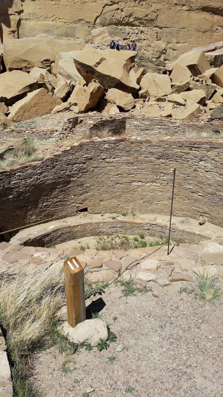 |
| #11 Pueblo Bonito Round kiva within a square walled structure |
 |
| 3# Pueblo Bonito View of the Plaza & kivas |

 |
| #5 Chetro Ketl - Great Kiva floor vaults right and left, round seating pits in front of vaults - fire pit in center Bench around the outside wall |

 |
| Pueblo Del Arroyo Looking down into a 3 story structure |
PUEBLO DEL ARROYO in Spanish meaning “village by the wash” was built over a relatively short period of time, from 1025 to 1125. This site also was named by LT James Simpson.

CASA RINCONADA is the name of the Great Kiva located here. The small villages and unexcavated mounds around this kiva are the remains of small villages. Casa Rinconada was the focus of the University of New Mexico archeological field school from 1936 -1947. Students either partially or completely excavated several small villages during the field school; others were backfilled or left unexcavated.
By the early 1100’s
Chaco Canyon had become a ceremonial, administrative and economic center. Road networks linked dozens of Great
Houses in the canyon to
others in the region. Remember that
these people had no beasts of burden (horses, mules, donkeys) or carts. Before
the “discovery” by Columbus the wheel had not
been used in the Americas.
 |
| #9 Casa Rinconada - The villages in this rincon (box canyon) were part of a dense settlement of approximately 50 villages. |
 |
| #8 Casa Rinconada - view of the Great Kiva from one of the surrounding villages |
 |
| Casa Rinconada - unexcavated village to the left along the trail |
By the late 1100’s,
reorganization of the Chacoan world led to a
shift in focus to other regional centers.
Chaco’s influence can be seen in places like Aztec, Mesa Verde, the Chuska
Mountains and other centers
of the north, south, and west.
SUNDAY May 8, 2016
MOTHER’S DAY
WEATHER: 41 at 5:45 am – mostly cloudy,
short period of rain, sometimes hail – high of low 60’s windy
 |
| Sacred Heart Cathedral - Gallup, NM |
TRAVEL: Gallup area
Mass 8 am at Sacred
Heart Cathedral in Gallup, NM - an
all brick structure on a hill about 4 ½ miles down US 66. Celebrant and a deacon with 3 servers – 2
boys in cassock and surplice; a girl in alb and cincture. A high mass – lots sung but no choir only an
organ and cantor.
The visit to Chaco
Culture NHP yesterday, was the
last of the NPS sites in it’s Southwest
Region.
ARKANSAS
27 APR 15 Arkansas Post NMEM
26 APR 15 Buffalo NR
26 APR 15 Fort Smith NHS
17 APR 15 Hot Springs NP
16 APR 15 Little Rock Central High School NHS
26 APR 15 Pea Ridge NMP
25 APR 15 William Jefferson Clinton Birth Home
LOUISIANA
7 APR 15 Cane River Creole NHP
21 MAR 15 Jean Lafitte NHP & PRES
19 MAR 15 New Orleans Jazz NHP
11 APR 15 Poverty Point NM
NEW MEXICO
7 MAY 16 Aztec Ruins NM
9 APR 16 Bandelier NM
7 APR 16 Capulin Volcano NM
19 MAR 16 Carlsbad Caverns NP
7 MAY 16 Chaco Culture NHP
3 MAY 16 El Malpais NM
3 MAY 16 El Morro NM
7 APR 16 Fort Union NM
15 MAR 16 Gila Cliff Dwellings NM
9 APR 16 Pecos NHP
1 MAY 16 Petroglyph NM
2 MAY 16 Salinas Pueblo Missions NM
11 APR 16 Valles Caldera
17 MAR 16 White Sands NM
OKLAHOMA
4 APR 16 Chickasaw NRA
2 APR 16 Washita Battlefield NHS
TEXAS
31 MAR 16 Albates Flint Quarries NM
27 APR 16 Amistad NRA
23 MAR 16 Big Bend NP
22 MAR 15 Big Thicket N PRES
16 MAR 16 Chimizal N MEM
22 MAR 16 Fort Davis NHS
19 MAR 16 Guadalupe Mountains NP
31 MAR 16 Lake Meredith NRA
29 MAR 15 Lyndon B. Johnson NHP
25 MAR 15 Padre Island NS
21 MAR 15 Palo Alto Battlefiedl NHP
23 MAR 16 Rio Grande WSR
17 MAR 15 San Antonio Missions NHP
Updated
pictures, blog and Quicken accounts.
MONDAY May 9, 2016
WEATHER: 41 and cloudy at 5:15 am, mostly
cloudy most of the day, high of 69
TRAVEL: USA RV Park to El
Morro to El
Malpais to USA
RV Park.
Rethinking the plan and route it would have been less miles and drive time if I had set up in Grants, NM (although not large Grants has a KOA and a Wal-Mart) to visit El Morro, El Malpais, Chaco Culture and Aztec Ruins, then moved to Gallup for Hubbell and Canyon de Chelley.
EL MORRO NM, made a purchase at the VC
EL MALPAIS Informational
Visitor Center, NM
 |
| The trail map does not show the trail to the Continental Divide Trail whihc adds another mile plus to the route. |
 |
| #1 El Calderon Trail Junction Cave Entrance really a lava tube with a collapsed ceiling so you can gain entrance |
 |
| #3 El Calderon Trail Xenolith (Bat) Cave Entrance |
There are a number
of caves (created by lava
tubes) along the trail. You can explore
the cave with a free permit and the recommended safety gear. I’m not doing wild caving alone.
 |
| #5 El Calderaon Trail - this is the front of the cinder cone. The trail leads to the left up and across the back side of the volcano crater and up to the top of the cinder cone. |
 |
| This was at the trailhead I came across some tracks that could have been . . . . should have taken a photo |
 |
| A marker for the Continental Divide Trail |
 |
| El Calderon Trail This is the turnoff to the "unimproved" and junction with the Continental Divide Trail |
The hike, including a portion of the Continental Divide Trail took about 1 hour 50 minutes. Relatively easy except for the short climb on trail steps to the top of El Calderon. The trail passes the entrances of 3 lave tube caves. You can take a shortcut back along Cerritas de Jasper Road that will save you a mile and about a ½ hour. The pictures should tell the story.
EL MALPAIS Visitor Center, Grants, NM
made a purchase
TUESDAY May 10, 2016
WEATHER: 43 at 6 am, clear and no wind .
. . . just seems warmer already
Sunrise 6:13 am MDT Sunset
8:09 pm MDT
TRAVEL: Gallup area
Laundry, washed
truck, updated blog, finally some time to read
WEDNESDAY May 11, 2016
WEATHER: 43 at 6 am, clear and no wind, FREEZE
WARNING for Cortez, CO
this evening. It got up to 60 at Mesa
Verde when the sky cleared. Still cool. At 7:30 pm the sun is warm but the sky is
clear – the heat will dissipate quickly – it will be a 3 dog night.
Mancos, CO EL 7,028’ Sunrise
6:08 am MDT Sunset 8:11 pm MDT
TRAVEL: USA RV Park Gallup, NM to Mesa Verde RV Resort Mesa
Verde, CO, a drive of 153
miles and 2 hours 50 minutes
Mesa Verde RV Resort – adequate, WIFI works, gravel sites, offers 20% /Military discount. Stay 6 the 7th is free . . . I’m
leaving on Tuesday anyway
The plan calls
for a night here;, May 12 and 13 up on Mesa Verde in the Lodge, return to the RV
Resort with visits to Cortez, CO for Yucca
House and Hovenweep
National Monuments
– probably a
drive to Durango, CO. Leave for
Holbrook, AZ and Petrified Forest NP on Tuesday May 17th.
 |
| Mesa Verde entrance sign there is a fee to enter the park |
 |
| Mesa Verde Visitor and Research Center |
Mesa Verde, Spanish for “green table,” offers a look into the lives of the Ancestral Pueblo people who made it their home for over 700 years, from AD 600 to 1300. Today the park protects nearly 5,000 known archeological sites, including 600 cliff dwellings. These sites are some of the most notable and best preserved in the United States..
Visitor and Research Center – rangers selling tour tickets and going through a memorized speil . .
. touristy. There doesn’t even appear to be much here
devoted to the history of the Ancient Puebloan people (Anasazai). A good portion of the Visitor
Research Center is devoted to
storage of artifacts in climate controlled rooms and a great place for the park
staff to work from.
 |
| This is not Mesa Verde but a view of the Rockies La Plata Mountain Range from the Mesa Verde Visitor Center at the Park entrance |
I drove up to Far View
Lodge and stopped at
several overlooks along the way. On my
previous visit I don’t remember stopping at these overlooks.
 |
| Mancos Valley Overlook |
Mancos Valley Overlook
 |
| Montezuma Valley Overlook |
Montezuma Valley Overlook
Park Point Lookout
 |
| Park Point Lookout - The Grandest View |
 |
| Park Point The Grandest View West - Ute Mountain |
 |
| Park Point map |
 |
| Park Point -The Grandest View East - Rocky Mountains |
Geologic Overlook
 |
| Geologic Overlook - A Monument To Time |
THURSDAY May 12, 2016
WEATHER: 33 at 5 am; clear, little wind
high in the low 70’s
Mancos, CO EL 7,028’ Sunrise 6:07 am MDT Sunset 8:12 pm MDT
TRAVEL: Mesa Verde RV Resort to Mesa Verde NP Far
View Lodge – Mesa Verde NP
296 MESA VERDE National Park, Mesa Verde, CO,

This was a full day
of walking and riding. I entered the park at 7:40 am; walked and saw sites;
checked into Far View Lodge at 4:30 pm only to give my phone a chance to re-charge and continued
seeing the park until 6 pm.
It may seem like
the sites and pictures are similar to Aztec NM or Chaco
Canyon, they are . .
. however, Mesa
Verde tells more of a
story from pit houses to the cliff dwellings.
The cliff dwellings were the culmination of a gradual improvement in
architecture for the Ancient Puebloan people (Anasazi) and like other puebloan sites these people left their
villages..
Two ranger guided
tour sites are CLOSED but I had previously visited both of the sites. Spruce Tree House is closed for safety reasons –
the trail is susceptible to rock falls.
The other site is Cliff House which doesn’t open until May 27th, Memorial Day weekend.
 |
| Far View Trail map |
 |
| Pipe Shrine house - 20 ground floor rooms - named for the dozen docrated clay pipes found in the large kiva by Walter Fewkes in 1922 |
 |
| Far View House - its location and large size suggest that it may have served as a public building. The vista inpsired Walter Fewkes to name it Far View. in 1916. |
The Far View Community included a reservoir (Mummy Lake) and system of ditches to collect and deliver water to the residents.
 |
| Believed to be an artificial reservoir. The circular depression is 90 feet in diameter and 12 feet deep, surrounded by a stone wall. The ramp indicates a walk in route to obtain water. The ditch on the left appears to be an intake channel. |
 |
| Farming Terrace Loop Trail - map |
Farming Terrace Loop – a short moderately strenuous ½ mile trail with an elevation change of
145 feet.
 |
| Farming Terrace Loop Trail - the stone walls are the remains of terraces |
 |
| Cedar Tree Tower |
 |
| Farming Terrace Loop Trail |
Cedar Tree Tower is off the Chapin Mesa Road, just down from the Farming Terrace Loop Trailhead.
Chapin Archeological
Museum – This location has
Park Headquarters, a Post Office, Bookstore, and a
concessionaire run cafeteria and gift shop.
You can view a 25 minute video about Mesa Verde.
 |
| These trail profiles shows the ups and downs of the trials. Spruce Canyon has the greatest elevation change but the Petroglyph Trail has steeper changes. Both are intersting walks. |
 |
| Spruce Canyon Trail |
Petroglyph Point Loop Trail - The 3 mile loop leads to the
Parks largest Petroglyph Panel. It also
starts at the top of Chapin Mesa. The
elevation change is 174 feet. A Trail
Guide that is describes
the vegetation at markers is available. Register
at the trailhead. .
 |
| Petroglyph Trail |
 |
| Spruce Canyon Trail the path up from the floor of the canyon |
 |
| Petroglyphs |
 |
| Petroglyph Trail - view from about center of the canyon wall |
Pictoglyph Point #24 on the trial, is the largest and best known group of petroglyphs in Mesa Verde. The panel is misnamed because the pictographs are painted on the rock where petroglyphs are carved into the rock. These are petroglyphs. In 1942 four Hopi interpreted some of the glyphs which basically is the migration story of the Pueblo people where they emerged from the earth at the “sipapu” (Grand Canyon) and how the clans came into being. Of course modern day interpretations may not be what the original artists meant.
 |
| Excavated Pithouse under a protective structure |
 |
| Pithouse Life |
 |
| Navajo Canyon Overlook |
 |
| Square Tower House site in cliff alcove |
Square Tower House Trail/Overlook - the name
Square Tower comes from the 4 story stone structure standing against the
curving back wall of the alcove. About
60 of the original 80 rooms remain.
 |
| Pithouse |
Pithouses & Early Pueblo Villages A.D. 700 – 950 - this site shows a trend toward deeper pithouses and the move from pithouses to above ground dwellings. These pithouses are D shaped and dug about 4 feet down. Deepening was a step along the way to a major transformation in the pueblo world – some pithouses would become special rooms where ceremonies were likely held.
 |
| Another excavated Pithouse |
Sun Point Pueblo A.D. 1200’s – this is one of the last mesa top pueblos built at Mesa Verde.
It is part of a cluster of sites in the Cliff Palace – Fewkes
Canyon group. The pueblo’s rooms enclosed a kiva-tower
complex. People lived here for only 10
years. There is no answer for why they
left.
 |
| Sun Point View - Looking across the canyon you can see a number of cliff dwellings. You would need a panoramic view to see them all. Oak Tree house is on the right. |
 |
| Fire Temple - note the large open plaza on the right front |
Oak Tree House A.D. 1250 - Archeologist Walter
Fewkes excavated the 50
room cliff dwelling called Oak Tree House.
 |
| Fire House |
Fire Temple and New Fire House A.D. 1250 – Fire Temple, near the head of Fewkes Canyon is probably not a place where people lived. Its large plaza may have been a stage for ceremonial dances. When the Smithsonian’s Jesse Walter Fewkes excavated the site in the early 1900’s he noted a rectangular floor plan. There was also a large floor cist and a slot cut across the floor. A reservoir was built above a spring to recharge the spring’s flow. Just to the right of Fire Temple is Fire House in upper and lower alcoves connected by a hand-and-toe hold trail shipped into the rock.

 |
| Sun Temple brickwork |
CLIFF PALACE LOOP is a 6 mile drive
Cliff Palace – this trail/tour is closed. It
opens May 27th Memorial Day weekend.
I have visited this site in the past.
This is the largest of the cliff dwellings in Mesa
Verde NP.
Far View Lodge has lodging and a restaurant, bar, cafeteria, gift shop, and fitness
center. This is a concession run by
Aramark. The room is large and adequate,
no TV – no microwave – there is a refrigerator & coffee maker. I’ve stayed here before.
FRIDAY May 13, 2016
FRIDAY the 13th
WEATHER: 34 at 5 am in Mesa Verde;
forecast high of 74, clear sunny skies
Far View Lodge Mesa Verde NP EL x,xxx’ Sunrise 6:06 am MDT Sunset 8:14 pm MDT
TRAVEL: Mesa Verde NP
 |
| This map is on the edge of the canyon above Balcony House. You have to drive down the canyon rim in order to get a view of Balcony House. |
CLIFF PALACE LOOP
Balcony House Tour with a ranger cost $4 @ 0930. Tours begin every 1/2 hour afterwards. It
is located on the Cliff Palace Loop.Road. The village offers a stunning view into Soda
Canyon, a tributary of
the Mancos River, and displays architectural features such as balconies, a long parapet
and a tunnel.
The builders of the
Balcony House lived and grew crops on the mesa tops until about A.D. 1300. However, beginning in A.D. 1200, many chose
to build their homes in the cliff-side alcoves.
In the 13th century Balcony House was part of a much larger
community. Eleven small sites are in the
immediate vicinity.
 |
| Trail down the cliff to get to Balcony House |
 |
| The Balcony above the open plaze and parapet which gives it the name |
 |
| 32 ft ladder to get into Balcony House |
This tour is
interesting in that you have to climb a 32 foot ladder to gain entrance to the
back of the site and crawl through two tunnels.
It could be a challenge for some people.
Tours are given every 30 minutes so you keep moving. The tour lasts one
hour.
 |
| Original hand and toe holes that were used to get down the cliff to the entrance. |
 |
| Balcony House |
 |
| You have to crawl to get out. This was the original way in. |
Balcony House is a typical medium sized two-story masonry structure. The stones were shaped into rectangular blocks and pecked on the surface. The stones were set in wet mortar mixed from tan and sandy soils and smoothed by hand. The masonry is some fo the finest in Mesa Verde. Some of the walls were plastered.
 |
| Soda Canyon Overlook |
 |
| Soda Canyon Overlook Trail map |
There was a
reliable seep spring at the rear of the alcove.
The parapet is unique to this site and the North
Plaza has many archeological
interpretations – most likely it was a place for meditation and prayer.
Soda Canyon Overlook Trail is on the Cliff Palace Loop Road. The trial is 1.2 miles round
trip with an elevation change of 145 feet. The canyon was named for the white
calcium carbonate deposits visible below the rim. The deposits are the evaporative remains of
seep springs once used by the Ancestral Publoan people.
WETHERILL MESA ROAD
Wetherill Mesa is open May through October (as weather permits). It is part of the park I had not visited
before. The 12 mile road ends at the Wetherill
Mesa Kiosk. From there, Long House Loop is a 6 mile long loop. This side of Mesa Verde is called the “quiet side” –
probably the “road less travelled.” I
didn’t visit here on my last visit because it was September and the roads were
closed. It appears that they have now
extended the season not closing until October.
 |
| Wetherill Mesa Road - Montezum Valley Overlook. In the past this area was also home to Ancestral Puebloans. The Hoevenweep and Yucca House sites are out there. It is estimated that 35,000 Ancestral Puebloans lived here in this Mesa Verde Area in the 1200's. Now there are 24,000 people living here. |
The Long House Loop is a 5-6 mile paved trail (again depending who you believe - NPS literature is contradictoy) that leads to the Kodak House Overlook and Long House Overlook Trails. The additional trips to the Overlooks and to the other pueblo sites along the trail probably make it a 7 mile walk – mostly level. It took me 2 hours and 30 minutes to make the hike. Not all is paved.
 |
| This is an enjoyable walk or bike ride. There are shaded places to eat a lunch or snack along the way. Like most NPS literature - don't believe all you read - the Nordenskioid Site #16 Trail along is 1 mile long and not included in the 5 mile trail information. |

There is a Wetherill Mess Information Kiosk is open May 14 - October 15. I’m a day early. I did buy a ticket for the Saturday 9:30 am Long House tour. This is part of the park that I hadn’t visited before.
 |
| Kodak House |

 |
| Nordenskoild #16 Trail map |
 |
| Nordenskoild #16 |
SATURDAY May 14, 2016
WEATHER: 40 at 5 am, partly cloudy, got up to 82 by 2 pm on the mesa
Far View Lodge Mesa Verde NP EL x,xxx’ Sunrise 6:06 am MDT Sunset 8:15 pm MDT
TRAVEL: Mesa Verde NP – Wetherill Mesa – Long House
Tour – Step House - Yucca House NM

Long House Trail – is a ranger led tour. Plan on
at least 2 hours, perhaps more to get there and back to the Kiosk.
Round trip distance is at least 2 ½ miles including the ¾ mile long walk to the site with switchbacks and stairs
and back
 |
| Long House triangular corner tower |
The great open kiva
(without a roof) serving as a central plaza, also suggests that it may have
been a public place where people from all over Wetherill Mesa gathered to trade or hold
community events. No roof allowed more
people to be in the kiva.
There is a well
preserved four-story tower triangular tower rises from floor to ceiling at the
far west end of the alcove provided access to the upper storage rooms above it.
 |
| Long House - large open plaza/kiva to the left front |
 |
| Hand Hewn timber with a stone ax - Long House |
 |
| Long House - quick brick work - not much skill or time taken to build this wall |
 |
| Seep Spring at the rear of Long House alcove |
 |
| Long House petroglyph Some petroglyphs here show 6 fingers on a hand |
 |
| Long house - Upper Level Storage Rooms |
A fallen 5 story
tower provided access to the other storage rooms above the plaza/great kiva.
 |
| Step House - Reconstructed pithouses in alcove |
 Step House Trail – is a .8 mile walk with an elevation change of 100 feet. It is mostly paved and includes several
stairways. It took me about 30 minutes
to walk the trail and view Step House.
Step House Trail – is a .8 mile walk with an elevation change of 100 feet. It is mostly paved and includes several
stairways. It took me about 30 minutes
to walk the trail and view Step House. |
| Step House Petroglyphs |
 |
| Step House Cliff Dwelling was probably built over several pithouses |
In the late 1800’s
the Step House alcove was explored by Swedish scientist Gustav
Nordenskiold and others. The site was re-excavated by Park
Superintendent Jesse Nusbaum in 1926. Nusbaum was interested in evidence of Basketmakers in the alcove.
Well crafted
baskets were found in the pithouses and
the people who lived in the area from 550 – 650 A.D. were called “basketmakers” by archeologists.
There is evidence
of a rock stairway to the alcove that gives the site its name Step House.
Unique to this site are the three pithouses in the alcove. The pithouses show that the Ancestral
Puebloans were using the alcoves long before their descendents
built the nearby cliff dwelling.
 |
| Seriously - this is the entrance ot Yucca House National Monumnet - the mounds you see in the background are unexcavated sites of the pueblos |
I spent only 30
minutes at this site. If you’re an
archeologist you could spend years here.
The site is unexcavated. The
pictures show a large Ancestral Publeoan pueblo with an estimated 600 rooms and over 100 kivas. There is a spring that flows through the
middle of the complex.
Yucca House National Monument preserves a large Ancestral
Puebloan surface site in southwestern Colorado. It is located west of Mesa
Verde National Park between the towns of Towaoc and Cortez. The ancient
structures are on the gently sloping base of the Sleeping Ute Mountain.
 |
| Yucca House - unexcavated site of pueblo |
 |
| Yucca House - unexcavated site |
 |
| Yucca House - this the only excavated wall on the site |
The land where Yucca House resides (approximately 10
acres) was a gift from the late Henry
Van Kleeck of Denver, Colorado. The stone used to build Yucca House is mainly fossilferous
limestone that outcrops along the base of the Mesa Verde tableland a mile away.
The mounds have been
known for many years, and were first described by Professor William H. Holmes in 1877. The two most
conspicuous mounds were designated by him as the "Upper House" and the "Lower House".
The former is the most
prominent of all the mounds in this ancient site, rising from 15 to 20 feet
above its foundation, and dominating the many smaller mounds which surround it.
The "Lower House" is different, and stands isolated by a
hundred yards from the cluster of mounds that compose and include the "Upper House".
There
are currently no facilities at Yucca House National
Monument.
The
monument is under the supervision of the Superintendent at Mesa Verde National Park.
SUNDAY May 15, 2016
WEATHER: 50 at 5:30 am, some clouds, it
rained last night
Mancos, CO EL 7,028’ Sunrise 6:03 am MDT Sunset 8:16 pm MDT
TRAVEL: Mesa Verde RV Park to Mancos,
CO to Hovenweep
NM; along the
Colorado/Utah border about 25 miles north of Cortez, CO
 |
| St. Rita's - Mancos, Colorado |
8:30 am Mass at St. Rita’s in Mancos, CO. Pentecost – the church was small but full with approximately 75 people. The priest moves on to a 10:30 mass in Cortez. Only 3 children attending mass with parents. No servers.
 |
| Hovenweep - sign at entrance to Square Tower site & Visitor Center |
Hovenweep is a one hour drive northwest of Mesa Verde – about 55 miles.
The land is mostly rural. It was
created by President Warren G. Harding on March 2, 1923. It was first reported “discovered” by W.D. Huntington in 1854 after he led a Morman Scouting
expedition into southeastern Utah. The
sites are located in Utah and Colorado.
 |
| Hovenweep map - most of the land surrounding the sites is managed by the Bureau of Land Management - Canyons of the Ancients NM |
Once
home to over 2,500 people, Hovenweep includes six
prehistoric villages built between A.D. 1200 and 1300. Explore a variety of
structures, including multistory towers perched on canyon rims and balanced on
boulders. Only the Visitor Center’s Square Tower Group
has a paved road leading to it. I
wouldn’t recommend the dirt & rock roads to the other sites for your BMW. Most of this land is under the jurisdiction
of the BLM
(Bureau of Land Management) not the NPS (National
Park Service). In my experience BLM,
and the USFS (United
States Forest Service) do little maintenance on roads.
 |
| The Square Tower Trail is located adjacent to eh Hovenweep Visitor Center. This was a good hike with a lot of sites. I'll only provide a few pictures. The end of the trail takes you down into and back up the side of the canyon. |
 |
| Twin Towers view from across the canyon on the Square Tower Trail |
 |
| View looking up the canyon |
 |
| Cutthrroat Castle Trail map of course you don't see the warning unless you get our of your car in the parking lot |
Most of the structures
at Hovenweep were built between A.D.
1200 and 1300. There is quite a variety of shapes and sizes, including square
and circular towers, D-shaped dwellings and many kivas. The masonry at Hovenweep is as skillful as it
is beautiful. Even the cliff dwellings of Mesa
Verde rarely exhibit such careful construction and attention to detail.
Some structures built on irregular boulders remain standing after more than 700
years.
 |
| Entrance to Horseshoee & Hackberry Units of Hovenweep - BLM lands surround the site |
 |
| I've seen a lot of Ancestral Puebloan sites and even though the cliff dwellings of Mesa Verde are remarkable, the sites here, especially Holly are fascinating. |
 |
| Horseshoe Tower Point ruin round - fine brick work preservation steps have been taken here - different colors |
 |
| Collared Lizard along the Horseshoe Trail Colors change depending on the lizards mood |
Cajon, Cutthroat Castle, Holly and Horseshoe/Hackberry are the outlying sites. Most areas have very short (a half mile or less one-way) trails which are primitive and lightly maintained. Backpacking is not permitted at Hovenweep. Outlier roads (BLM) may become inaccessible during inclement weather.
Each of the following sites is an adventure in itself to get to . . . .
The
Horseshoe and Hackberry Units have fine
examples of "D-shaped" towers. The Cutthroat Castle Unit is situated
among pinyon trees. The trail is just over 1 mile round-trip.
 |
| Hackberry Trail note the cairns |
 |
| Hackberry ruins |
The Holly Unit features a petroglyph sun panel and amazing architecture
 |
| Holly - impressive built on the sheer sides of an island cliff |
 |
| Holly |
 |
| Holly Petroglyphs |
 |
| Cajon - the spring was vital to survival - there is still flow today Most of the dwellings are built on top - but there are cliff dwellings in the alcove of the canyon |
 |
| Cajon fuins |
The Cajon Unit overlooks Monument Valley 50 miles to the Southwest and is particularly beautiful at sunset.
The
Cutthroat Castle Unit is situated among pinyon
trees.
 |
| Cutthroat Castle ruins |
 |
| Canyon of the Ancients managed by the BLM |
 |
| Cutthroat Castle trail |
 |
| Cutthroat Castle ruin |
Many theories attempt to
explain the use of the buildings at Hovenweep. The striking towers might have
been celestial observatories, defensive structures, storage facilities, civil
buildings, homes or any combination of the above. While archeologists have
found that most towers were associated with kivas, their actual function
remains a mystery.
MONDAY May 16, 2016
WEATHER: 45 at 6am; mostly clear – then
clouds rolled in from the southwest through most of the morning; rain on Mesa
Verde; rained most of
the afternoon – occasional lightning Mancos,
CO EL 7,028’ Sunrise 6:02 am MDT Sunset 8:17
pm MDT
TRAVEL: Mesa Verde RV Resort to Durango, CO to Mesa
Verde RV Resort
A day of rest
and catch-up – laundry, clean the truck & trailer in and out; continue to
update the blog and label the 378 pictures I’ve taken over the last 4
days. Maybe I’ll get to read today.
I thought about a drive to FOUR CORNERS – but
I have no interest – I’m in the “four corners area” – and I’ve heard that there
is a charge to get to the place. Not
that important.
“Travel is fatal to bigotry, prejudice and narrow mindedness.” Mark Twain
The
Visitor Center is 25 miles east of Holbrook, AZ (“a town
to tough for women or churches”). I had
been to Petrified Forest NP/Painted Desert before with my
parents on a return trip from Philmont Scout Ranch – it may have
been 1965. It was a whirlwind trip
leaving Cimarron, NM on a Friday - going to Petrified Forest NP – Grand Canyon
NP (Friday night & Saturday morning) –
through Salt Lake City – Yellowstone NP – Black Hills – Mt. Rushmore
and my dad drove through the night on Sunday – I think he was a bit late for
work we dropped him off on Monday around 9am. – don’t know how he did it.
Unfortunately, I didn’t meet a friendly person at the desk or in the park . . . “hellos or good afternoons” were just ignored. The
people at the desk could have cared less – just another tourist . . . . NOT! There is a good 28 minute video.
Amazing color - the photos do not do the Painted Desert justice and remember the weather was cool and overcast.
Auto Tour Stop 13 Fossilization Trees to Stone - there is no marker just a ranger filling time on the CD. Arizona had one of the largest concentrations of petrified wood in the world. Petrified wood is the state fossil of Arizona. About 220 million years Arizona was near the equator in Pangea. Fossilized trunks are visible - the trees were knocked down by wind or water and buried in layers of sediment. The logs soaked up groundwater and silica from the volcanic ash and overtime crystallized into quartz - agate.
TUESDAY May 17, 2016
WEATHER: rained again overnight; 38 at 4:30 am; the sky was clear and the stars were
bright. Aurora was peeking over the
mountains to the east. Rain started
again around 5 pm. Mancos, CO EL 7,028’ Sunrise 6:02 am MDT Holbrook, AZ EL Sunset 7:19 pm MST/PDT
TRAVEL: Mesa Verde RV Resort, Mancos,
CO to Holbrook
Petrified Forest KOA, Holbrook, AZ I’m in Arizona and they don’t adopt
DST so I gained an hour – 7 am CDT is 5 am in AZ MST or PDT – I’m not sure AZ
knows for sure. BOTTOM LINE: The
sunrise and sunset is earlier than in
Gallup or Mancos.
Petrified Forest KOA – Holbrook, AZ – another KOA – ho-hum –
President’s Award Banner – yeah yeah -
gravel sites – little gravel mostly desert – hope the rain doesn’t turn
it to red mud. And yes, I-40 adjoins the property (what good is a KOA if you
can’t hear the trucks) even though you drive almost a mile from I-40 to get
here. They do have an open air “cowboy
cookout” . . . steak,
burgers, hot dogs from 5:30 – 7:30 pm.
Not too enjoyable in the rain . . .
also breakfast 7-9 am all-you-can-eat pancakes and coffee for $2.99. Hope it stops raining. WIFI way too SLOOOOOW – maybe it’s the weather – I
expected better got disconnected several times – lost work on the blog at night. The best time to post and update is in the morning.
299 PETRIFIED FOREST National Park, 1 Park
Road,
Petrified Forest, AZ
Petrified Forest, AZ
 |
| Petrified Forest Entrance |
 |
| Even this map is hard to read - but Petrified Forest NP covers a lot of ground. The only ranger I saw was at the entrance/fee station - not very friendly asking me if I had any rocks of petrified word in the truck? I thought the question would be more appropriate on leaving the park. Of course there was no question or ranger when I left the park. |
Unfortunately, I didn’t meet a friendly person at the desk or in the park . . . “hellos or good afternoons” were just ignored. The
people at the desk could have cared less – just another tourist . . . . NOT! There is a good 28 minute video.
I
purchased a audio CD of the drive tour and covered 12 stops and 2 short trails
before I headed back to the Holbrook KOA. The pictures should tell the story
 |
| Auto Tour Stop 2 Painted Desert Rim Trail – 1 mile round trip from Tawa Point to Kachina Point and the Desert Inn. Average Grade 6.3%; Max 25.6% |
 |
| Auto Tour Stop 2 Painted Desert Rim Trail |
 |
| Auto Tour Stop 2 Painted Desert Rim Trail |
 |
| Auto Tour Stop 2 Painted Desert Rim Trail |
Amazing color - the photos do not do the Painted Desert justice and remember the weather was cool and overcast.
 |
| Auto Tour Stop 3 Painted Desert Inn - originally called the Stone Tree House built of petrified wood in 1924 by David Lore who operated here for 12 years. Lore sold the building to the NPS in 1936. It was renovated into a Pueblo Revival Style by the CCC and opened in 1940. It closed during WW II and reopened in 1947 under the management of the Fred Harvey Company (Harvey Girls). It was again renovated; the wall murals were painted by Fred Kabotie - a Hopi artist. Structural damage forced the Fred Harvey Company to move to the "new" Visitor Center in 1963. NPS "modernized" some of the structural components of the building and presents the in its 1940s heyday. . |
 |
| Auto Tour Stop 4 Chinde Point - Chinde is a Navajo term that means "evil spirit" or "ghost". This is also the area where "Gertie" a meat-eating dinosaur about the size of a kamodo dragon was found in 1985. "Gertie" lived about 200-250 million years ago. |
 |
| Auto Tour Stop 7 Whipple Point - Lt Whipple in 1853 explored a possible route for the railroad he was here |
 |
| Auto Tour Stop 5 Pintado Point - in Spanish pintado means "painted" |
 |
| Auto Tour Stop 6 Nizhoni Point - in Navajo nizhoni means "beautiful" |
 |
| Auto Tour Stop 8 Lacy Point - named after Congressman John F. Lacy who worked for the protection of Petrified Forest |
 |
| This movie poster was in the Painted Desert Inn. A 1946 MGM musical. The Painted Desert Inn was a Harvey Company business in the 1940's. |
 |
| Auto Tour Stop 9 Route 66 - This was the only NP where Route 66 passed through a NP. Bobby Troupe pianist with the Tommy Dorsey Band - wrote a tune in 1946. Nat King Cole recorded it and now we have "get your kicks on Route 66." |
 |
| Auto Tour Stop 10 Railroads & Fred Harvey - This was the original Santa Fe RR right-of -way; Later it became the AT&SF Atchison, Topeka & Sante Fe; now its the BNSF - Burllington Northern and Santa Fe. |
 |
| Auto Tour Stop 11 Puerco Pueblo - Map a short .3 mile paved walk amidst the remains of a hundred room pueblo, occupied by the Ancestral Puebloan people over 600 years ago. There are some interesting Petroglyphs along the south end of the trail |
 |
| Auto Tour Stop 11 Puerco Pueblo - square kiva |
 |
| Auto Tour Stop 11 Puerco Pueblo - petroglyphs |
 |
| Auto Tour Stop 11 Puerco Pueblo - excavated walls |
 |
| Auto Tour Stop 11 Puerco Pueblo - artist conception |
Auto Tour Stop 13 Fossilization Trees to Stone - there is no marker just a ranger filling time on the CD. Arizona had one of the largest concentrations of petrified wood in the world. Petrified wood is the state fossil of Arizona. About 220 million years Arizona was near the equator in Pangea. Fossilized trunks are visible - the trees were knocked down by wind or water and buried in layers of sediment. The logs soaked up groundwater and silica from the volcanic ash and overtime crystallized into quartz - agate.
 |
| Auto Tour Stop 12 Newspaper Rock This was a none event - the above is a picture of the rock. You can't get this close. |
 |
| Auto Tour Stop 14 Tepees - conical hills formed after years of erosion. It started to rain shortly after this stop. |
WEDNESDAY May 18, 2016
WEATHER: 48 at 5 am in Holbrook, cloudy, it rained from 7-9 am, off and on the rest of the day, high low 60’s - forecast
for today
Holbrook, AZ EL 5,079’ Sunrise 5:14 am MST Sunset 7:20 pm MST
TRAVEL: 60 miles west of Holbrook,
AZ, just southwest
of Winslow, AZ off of I-40. I-40 closely follows
“old Route 66.” Gallup, Petrified Forest NP, Holbrook, and Winslow were on Route
66.
Based on the
weather forecast, today looks like a candidate for visiting Meteor
Crater and finish the
day possibly hiking in Petrified Forest NP. Tomorrow -
forecast is sunny and in the 70’s.
METEOR CRATER
Admission is
$18. Active Duty Military Free – Veterans
with ID $9. There is a nice Visitor
Center and viewing area on 3 levels; a short film, and a museum. This is a good visit – about 1 ½ hours max –
only a few miles south of I-40.
 |
| Meteor Crater - picture from the web. The sky was not that blue today. |
 Meteor
Crater’s “IMPACT,
Mystery of Meteor Crater” movie, features
3D modeling and animation to give the viewer a sense of the explosive fury. The spectacular result of the collision that
rocked the American Southwest with the energy of more than 20 million tons of
TNT can be explored first-hand just outside the Discovery
Center
museum.
Meteor
Crater’s “IMPACT,
Mystery of Meteor Crater” movie, features
3D modeling and animation to give the viewer a sense of the explosive fury. The spectacular result of the collision that
rocked the American Southwest with the energy of more than 20 million tons of
TNT can be explored first-hand just outside the Discovery
Center
museum.
This
impact occurred 50,000 years ago. Large
blocks of limestone, the size of small houses were heaved onto the rim. Meteorite fragments that broke away early
from the main mass continued to fall at lower velocities. During impact it is believed that the meteor
was intensely fragmented, almost half into microscopic iron-nickel spherules.

In 1902, Daniel Moreau Barringer, a
 |
| Meteor Crater Visitor Center & Museum |
Still,
his theory of impact origin started to gain acceptance among the scientific
community. In 1960, Dr. Eugene Shoemaker proved beyond a doubt that Meteor Crater was the
product of a giant impact. From
1964-1972 the USGS and NASA trained
astronauts at the site to learn about collecting samples on the moon.

18 Jasper Forest Trail – considered an off-the-beaten- path trail. A 2 ½ mile round trip on an old road among petrified wood. The old road is only part of the way, then it is kind of a free-form make your own trail trip. It is off-the-beaten-path i.e not marked.


J&H RV Park is a small park
– 51 sites - nicely set-up and maintained.
Each site has a shade tree, sites are level cinders with, a poured
concrete pad that you can line you trailer up on with a built in picnic table. WIFI
works fine.

300 WALNUT CANYON National Monument, 3 Walnut Canyon Rd, Flagstaff, AZ EL 6690’

 There are two trails. The Rim and Island
Trail. The Island Trail is closed May 1-31 for
There are two trails. The Rim and Island
Trail. The Island Trail is closed May 1-31 for
renovation and repair. It is a paved, one mile round-trip, trail leading 185 vertical feet down to view the cliff dwellings.
I walked the .7 mile Rim Trail which is mostly paved and fairly level. It was marked well as a Nature Trail.
301 SUNSET CRATER VOLCANO National Monument, 6082 FS 545 EL 8,041’ at the rim
The
Lava Flow Trail has a trail guide that you can
purchase of $2 at the VC. There are
several short trails that I’ll walk later on.
It is an easy to moderate, 1 mile round trip trail. A ¼ mile of the trail is pave.
302 WUPATKI National Monument, 25137 N Wupatki
Loop Rd,
Flagstaff, AZ EL 5,000’

Wupatki National Monument offers a variety of guided hikes from October through April. These hikes range from moderate to very strenuous, and can last anywhere from two hours to two days.
Guided
hikes provide the only public access to many areas of the monument. There are ranger led, overnight, backcountry hikes
available by lottery – not enough time – but it appears there is a lot to see
in the backcountry.
WUPATKI PUEBLO is the largest pueblo in the park. A self-guided trail begins behind the visitor center. I bought a Trail Guide and I’ll walk this later.
303 MONTEZUMA CASTLE National Monument, Camp Verde, AZ
The
Visitor Center, Gift Shop and small Museum was
crowded. Lots of families . . . .
there
is a concrete-paved trail that lets you see the ruins but you cannot enter
them.
The museum does a good job of explaining the Sinagua culture.
 On
December 8, 1906, President Theodore
Roosevelt celebrated the passage of the Antiquities Act by declaring four sites of historic and cultural
significance as our nation's first National
Monuments. Among these was Montezuma
Castle, which the President identified as a place "of the greatest ethnological value and scientific interest."
Although very few original artifacts remained in the structure due to intensive
looting of the site, Roosevelt's
decision assured the continued protection of one of the best preserved
prehistoric cliff dwellings in North America.
On
December 8, 1906, President Theodore
Roosevelt celebrated the passage of the Antiquities Act by declaring four sites of historic and cultural
significance as our nation's first National
Monuments. Among these was Montezuma
Castle, which the President identified as a place "of the greatest ethnological value and scientific interest."
Although very few original artifacts remained in the structure due to intensive
looting of the site, Roosevelt's
decision assured the continued protection of one of the best preserved
prehistoric cliff dwellings in North America.
Montezuma Castle National Monument quickly became a destination for America's first car-bound tourists. In 1933, "Castle A", a 45-50 room, pueblo ruin was excavated, uncovering a wealth of artifacts and greatly enhanced our understanding of the Sinagua people who inhabited this riparian "oasis" along Beaver Creek for over 400 years.
Early visitors to the monument were allowed access to the structure by climbing a series of ladders up the side of the limestone cliffs. However, due to extensive damage to this valuable cultural landmark, public access of the ruins was discontinued in 1951.
304 TURZIGOOT National Monument, 25 Turzigoot
Rd, Clarkdale, AZ
Tuzigoot, Apache for “crooked
water,” crowns the summit of a long ridge rising 120 feet above the Verde Valley. The
original pueblo was two stories high in some places. There were few exterior doors; entry was by
ladders through the roof openings. The
village began as a small cluster of rooms inhabited by some 50 people for 100
years. In the 1200’s the population
doubled then doubled again.
After
visiting Tuzigoot, I drove north on AZ 89A to the Lower Red Rock Loop Road - RED ROCK STATE
PARK –
Upper Red Rock Loop Road and then to
Sedona. The drive from the south is not
heavily traveled – seems most of the traffic comes from the north. I did not enter or pay the fee for Red Rock State Park. Only
hiking trails there. The drive was
scenic but most of the property is privately owned. The drive is not through a park..
Sedona is an Arizona desert town south of Flagstaff, north of Cottonwood, that’s surrounded by red-rock buttes, steep canyon walls and pine forests. It’s noted for its mild climate and vibrant arts community. Uptown Sedona is dense with New Age shops, spas and art galleries.
The
drive north through Sedona, the Coconino
Forest
and the canyon was very scenic. I was
headed north and it was a weekend and the traffic into Sedona
from the north was backed up for two miles – probably best not to visit on a weekend.
Attended 8 am mass at St. Francis de Asis
Church. This parish has an address of
1600 E Route 66 in Flagstaff but you have to look behind the Starbuck’s and up
about a ¼ mile of private road or more to find it. A large school, campus and church. A deacon, visiting priest, all male acolytes
and a 20 person choir (about the same age as St. Mary’s choir) with trumpet, organ,
piano, flute. At least they sang in two
parts – men & women – no screechers or wailers.) Trinity Sunday – 6 communion stations – mass
was well attended.
301 SUNSET CRATER VOLCANO National Monument,
6082 FS 545 EL 8,041’ at rim
 The
Lava Flow Trail is a moderate 1 mile round trip
with rough surfaces through lava flows and cinder barrens to the base of
Sunset Crater. It has 12 stops along the
trail described in a Trail Guide.
The
Lava Flow Trail is a moderate 1 mile round trip
with rough surfaces through lava flows and cinder barrens to the base of
Sunset Crater. It has 12 stops along the
trail described in a Trail Guide.
The white path on the photo to the left is paved concrete and wheel chair accessible.
302 WUPATKI National Monument, 25137 N Wupatki
Loop Rd, Flagstaff, AZ EL 5,000’

The Wupatki Pueblo Trail is a ½ mile round trip paved with some steps and inclines.
This village like
those of the Ancestral Puebloan people were settled and left for reasons we may
never fully understand. By 1300, across
the region people had moved into other
villages even larger than Wupatki at places like Honol’ovi along the Little
Colorado River (near Winslow) or at villages south of Walnut Canyon.
These people like most of the “ancestral” peoples raised corn, beans, and squash – all unknown to the “Old World” of Europe, Africa and Asia before the discovery of the Americas. It is interesting to note that the potato and tomato were also unique to the Americas and not introduced to Europe until after the “Columbian Moment.” Can you imagine Italian food without tomatoes or Irish stew without the potato.
Wuukoki Pueblo Trail – built on a sandstone outcrop, this pueblo is unique for its
structure and location. This is an easy
.2 mile walk.
MONDAY May 23, 2016
At the Grand
Canyon Visitor Center I viewed two
videos and spoke to a ranger about the
trails. Good INT – seems the earlier to
start the trails the better – avoids the crowds.- BRIGHT
ANGEL - RIM – SOUTH KAIBAB
are on my list to complete when I’m here in June. The Park Bus is the only way to get to Hermit’s
Rest in order to walk
the 14 mile long RIM TRAIL to the SOUTH
KAIBAB Trailhead and take
the bus back.
I arrived at the Verkamps
Visitor Center around noon but no
parking – lesson learned get here early or take the bus. I drove the Village Loop Drive to the El
Tovar Hotel, Bright Angel Lodge, Maswik Lodge and past the Train Depot. It was busy but not too crowded –
something tells me there will be more people here in June...
THURSDAY May 19, 2016
WEATHER: 41 at 5:00 am - clear – high in mid 70s
Holbrook, AZ EL 5,079’ Sunrise 5:13 am MST Sunset 7:21 pm MST
TRAVEL: Holbrook to Petrified Forest NP to Holbrook
Petrified Forest KOA: WIFI
met all
expectations last night, perhaps the unreliability Tuesday night was due to weather. Well, now it’s Thursday night and I can’t
connect – perhaps it’s an issue of bandwidth or connection is untenable in
the evening on days that begin with “T”.
A couple at Meteor
Crater yesterday
indicated that Sedona was a place to
visit – perhaps I’ll check it out.
Drove through Winslow, Arizona (old Route 66)
yesterday; never saw “a flatbed Ford”
and no one “slowed down to take a look at
me.”
299 PETRIFIED FOREST National Park, 1 Park
Road, Petrified Forest, AZ
15 Blue Mesa Trail –
a 1 mile loop that enters the vibrant blue, purple and gray badlands. Blue, grey, white, lavender colors about the result of mineral deposits in the Chnle Formation.. Once called the "Blue Forest" by John Muir. I think the word "purple" describes the formation better than blue.
 |
| Auto Tour Stop 15 - this is a short trail. Like most trails in the park it is paved. A good walk. |
 |
| Auto Tour Stop 15 Blue Mesa Trail |
 |
| Auto Tour Stop 15 Blue Mesa Trail |
 |
| Auto Tour Stop 15 Blue Mesa Trail - Petrified Wood pieces are everywhere |
 |
| Auto Tour Stop 15 Blue Mesa Trail Yes, the rocks are petrified wood. |

 |
| Auto Tour Stop 17 - Agate Bridge The railroad put the support under it in 1912. |
 |
| Auto Tour Stop 18 - Jasper Forest |
18 Jasper Forest Trail – considered an off-the-beaten- path trail. A 2 ½ mile round trip on an old road among petrified wood. The old road is only part of the way, then it is kind of a free-form make your own trail trip. It is off-the-beaten-path i.e not marked.


 |
| Auto Tour Stop 18 Jasper Forest Off-the-beaten-track Trail Jasper for red hues of the petrified wood here |
 |
| Auto Tour Stop 18 Jasper Forest Off-the-beaten-track Trail Unique - this looked like split pulp wood. When I picked it up - petrified. |
 |
| Auto Tour Stop 18 Jasper Forest Off-the-beaten-track Trail This is a larger piece of petrified wood. There are literally, millions and millions of chips and smaller peices everywhere. |
 |
Auto Tour Stop 19 - Crystal Forest Trail – a .8 mile asphalt trail loop with an elevation gain of 122 feet, grades are up to 20%
|
|
| Auto Tour Stop 19 - Crystal Forest Trail – This tells you how petirfied wood was formed. It is also useful to remember that when the petrified forest wood was buried under sediment and ash the location of Arizaona was as part of the supercontinent Pangea. Arizona was in the latitude of Central America near where Costa Rica is today. The Triassic Period (240-205 million years ago) was in the Mesozoic Era (240-63 million years ago). The Mesozoic Era was the Age of Reptiles. The Triassic Period was followed by the Jurassic (205-138 million years ago.). |
 |
| Auto Tour Stop 19Crystal Forest Trail – |

 |
| Auto Tour Stop 21 - Long Logs & Agate House Trail map |
21 Long Logs & Agate House. The Long Logs and Agate House Trails are combined here for a total of 2.6 miles. The Long Logs Trail is covered in especially long petrified tree trunks. The Agate House is a 7 room reconstructed pueblo.
 |
| Auto Tour Stop 21 - Long Logs & Agate House Trail This is Agate House - most liklely a single family home built of petrified wood. The WPA (CCC) rebuilt much of this site during the 1930's. |
 |
| Auto Tour Stop 21 - Long Logs & Agate House Trail - one of many long logs on this trail. |
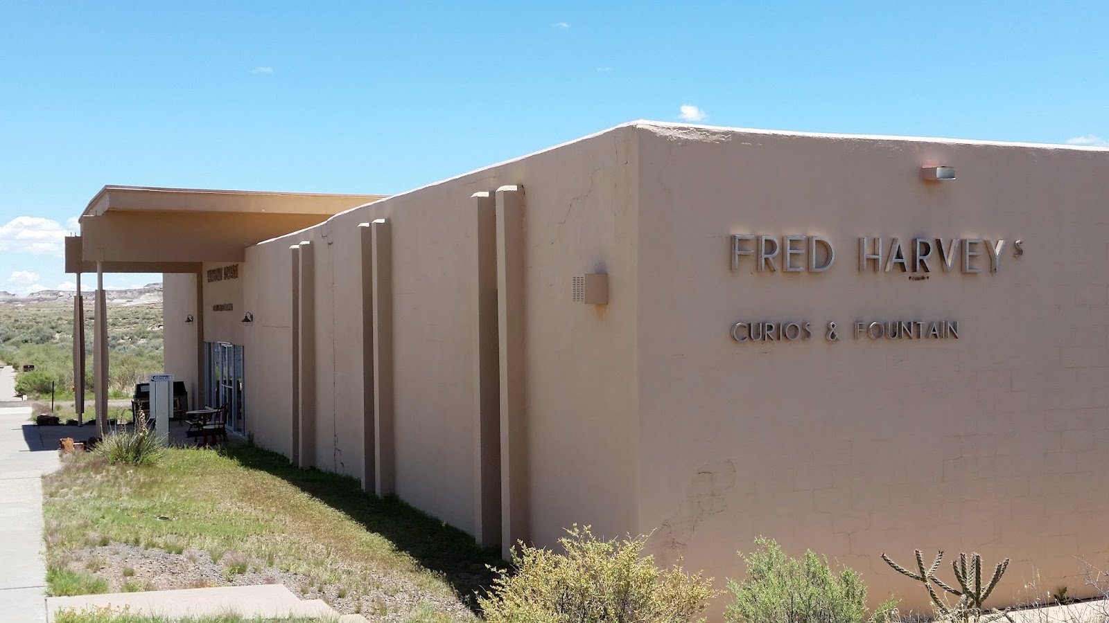 |
| Auto Tour Stop 22 Giant Logs & Rainbow Forest Museum Note the "Fred Harvey Curios & Fountain" Only a gift shop in here now. Rainbow Forest was the original entrance to the park before I-40. |
 |
| Auto Tour Stop 22 Giant Logs & Rainbow Forest VC & Museum |
 |
| Auto Tour Stop 22 Giant Logs & Rainbow Forest - Giant Logs Trail |
 |
| Auto Tour Stop 22 Giant Logs & Rainbow Forest - This is called "Old Faithful" almost 10ft across |
FRIDAY May 20, 2016
WEATHER: 51 at 5:00 am - partly cloudy - clear, and in the 70’s by 8am. Windy.
Holbrook, AZ EL 5,079’ Sunrise 5:13 am MST Flagstaff, AZ EL 6,909’ Sunset 7:28 pm MST
TRAVEL: Petrified Forest KOA, Holbrook,
AZ to J&H RV
Park, Flagstaff, AZ. It was an uphill climb. Flagstaff Is at the foot of the San
Francisco, Mountains
 |
| Trailer in J&H RV Park |
 |
| Not the best picture but this map gives you a good idea of the proximity of the 3 National Monuments. You can visit all of them in a day. There are fees. |
Triple Crown in NPS
sites today. I first went to Walnut Canyon NM about a 10 mile drive – I walked the one
trail that was open and moved on to Sunset Crater
Volcano NM
which is adjacent to Wupatki NM. All
are within 30 minutes of where I am staying.
I considered the Sunset Crater and Wupatki visits a recon – I’ll return back to hike the
trails.
I reached a MILESTONE today – I’ve visited #300, 301 & 302 of the 411 sites administered by the National Park Service. If
all goes well this year the plan calls for 341 before I come home in September.

300 WALNUT CANYON National Monument, 3 Walnut Canyon Rd, Flagstaff, AZ EL 6690’
Just imagine – more
cliff dwellings . . . . similar but different - - - these people are may be called Ancestral
Puebloans but the literature
commonly refers to them as the Sinagua. It is generally believed that
they were eventually assimilated into the Hopi Culture.
The Hopi today call their
ancestors the Hisatsinom (“people of long
ago”). Their tradition suggests that these
early migrations were part of a religious quest to have all the clans come
together.
There is a Visitor
Center, on the rim of the
canyon, with a small bookstore, museum and 20 minute video. This site was staffed by some very
knowledgeable and friendly volunteers. I
enjoyed talking with one of them on the Rim Trail.

 There are two trails. The Rim and Island
Trail. The Island Trail is closed May 1-31 for
There are two trails. The Rim and Island
Trail. The Island Trail is closed May 1-31 for renovation and repair. It is a paved, one mile round-trip, trail leading 185 vertical feet down to view the cliff dwellings.
 |
| Rim Trail Interpretive Marker - Sinagua Culture |
 |
| Rim Trail - Walnut Canyon Note sharp fault in the canyon |
 |
| Rim Trail - unexcavated pubblo |
 |
| Rim Trail - Excavated Two Room Pueblo |
I walked the .7 mile Rim Trail which is mostly paved and fairly level. It was marked well as a Nature Trail.
I spent a little
more than an hour here. If the Island
Trail is open, plan
about 3 hours to visit this place. The
short drive to the VC off of I-40 a very
pleasant drive through the pine forest.
 |
| Sunset Crater Volcano NM NO CLIMBING ALLOWED No back-country hiking at this site and at Wupatki NM |
 |
| Sunset Crater Volcano NM Entrance sign from the north Sunset Crater in the background |
301 SUNSET CRATER VOLCANO National Monument, 6082 FS 545 EL 8,041’ at the rim
There
is a small Visitor Center, museum and bookstore. Emphasis on volcanoes of the past.
After
a stop at the VC I drove a 34 mile scenic loop drive that winds from Highway 89
through Sunset Crater Volcano and Wupatki National Monuments. The scenic loop leads you from the high
Ponderosa Pine forests of Sunset Crater, down nearly 2,000 feet in elevation to
the red rocks and painted desert vistas of Wupatki. This was a good recon.
 |
| Sunset Crater Volcano cinder cone |
 |
| Sunset Crater Volcano National Monument map |
The
Lenox Crater Trail is a strenuous 1 mile round trip trail up steep slopes covered
with loose cinders.
I’ll
walk these trails in a few days.
 |
| Wupatki entrance sign |
Flagstaff, AZ EL 5,000’
Located
between the Painted Desert and ponderosa highlands of
northern Arizona, Wupatki is a landscape of legacies. Ancient pueblos
dot red-rock outcroppings across miles of prairie. Where food and water seem
impossible to find, people built pueblos, raised families, farmed, traded, and
thrived.

Wupatki National Monument offers a variety of guided hikes from October through April. These hikes range from moderate to very strenuous, and can last anywhere from two hours to two days.
 |
| Wupatki Pueblo |
 |
| Wupatki Pueblo |
WUPATKI PUEBLO is the largest pueblo in the park. A self-guided trail begins behind the visitor center. I bought a Trail Guide and I’ll walk this later.
People
gathered here during the 1100s, gradually building this 100-room pueblo with a
community room and ball court. By 1182, perhaps 85 to 100 people lived at Wupatki Pueblo, the largest building for at least fifty miles. Within a
day's walk, a population of several thousand surrounded Wupatki.
Though
it is no longer physically occupied, Hopi
believe the people who lived and died here remain as spiritual guardians.
Stories of Wupatki are passed on
among Hopi, Zuni, Navajo, and perhaps other tribes. Members of the Hopi Bear, Sand, Lizard, Rattlesnake,
Water, Snow, and Katsina Clans return periodically to enrich their personal
understanding of their clan history. Wupatki
is remembered and cared for. It is not abandoned.
SATURDAY May 21, 2016
WEATHER: 48 at 5:15 am - mostly sunny - still windy.
Flagstaff, AZ EL 6,909’ Sunrise 5:18 am MST Sunset 7:29 pm MST
TRAVEL: J&H RV Park to Montezuma
Well to Montezuma
Castle through Cottonwood,
AZ to Tuzigoot
NM to Sedona,
AZ and return to Flagstaff.
 |
| Montezum Well sign |
303 MONTEZUMA CASTLE National Monument, Camp Verde, AZ
I
visited Montezuma Well a unit of Montezuma Castle NM first. There is a 1/3-mile loop that
goes past an oasis, used by the Sinagua people over 600
years ago. Just a contact station here –
but in my opinion more to see than at Montezuma
Castle. There were 20-30 folks involved in a
“bio-day” looking for invertebrae in the water, the spring and off the trail. Beaver Creek runs past the
well and its outlet.
 |
| Montezuma Well is an interesting visit - a bit off the the beaten track but worth the visit. The trail is full of good cultural and nature information. This may be a better visit than then the main unit Montezuma Castle. |
 |
| Montezuma Well - an oasis in the desert. A spring fed limestone sink about 53 feet deep. The outlet is a seep spring above Beaver Creek. The Sinagua built several miles of irrigation canal using this water and diverting its flowing into Beaver Creek. The flow is actually very strong. |
 |
| Montezuma Well - This is the outlet from the well A strong steady flow through a seep spring. I visited on a"bio day" where invertebrates were being collected - that's the reason for the yellow measuring tape. |
 |
| Montezuma Well - Cliff Dwellings - no surprise |
 |
| Montezuma Well Pueblos on top of the wells rim |
Montezuma Castle National Monument preserves
dwellings built by the Southern Sinagua Culture between
1100 and 1425 CE. Yes, this is another
“cliff dwelling.”
 |
| Montezuma Castle entrance sign |
 |
| Montezuma Castle This is about as close as you will get. |
The museum does a good job of explaining the Sinagua culture.
 On
December 8, 1906, President Theodore
Roosevelt celebrated the passage of the Antiquities Act by declaring four sites of historic and cultural
significance as our nation's first National
Monuments. Among these was Montezuma
Castle, which the President identified as a place "of the greatest ethnological value and scientific interest."
Although very few original artifacts remained in the structure due to intensive
looting of the site, Roosevelt's
decision assured the continued protection of one of the best preserved
prehistoric cliff dwellings in North America.
On
December 8, 1906, President Theodore
Roosevelt celebrated the passage of the Antiquities Act by declaring four sites of historic and cultural
significance as our nation's first National
Monuments. Among these was Montezuma
Castle, which the President identified as a place "of the greatest ethnological value and scientific interest."
Although very few original artifacts remained in the structure due to intensive
looting of the site, Roosevelt's
decision assured the continued protection of one of the best preserved
prehistoric cliff dwellings in North America. |
| Map of Arizona with location of current tribes in relation to location of Montezuma Castle |
Montezuma Castle National Monument quickly became a destination for America's first car-bound tourists. In 1933, "Castle A", a 45-50 room, pueblo ruin was excavated, uncovering a wealth of artifacts and greatly enhanced our understanding of the Sinagua people who inhabited this riparian "oasis" along Beaver Creek for over 400 years.
Early visitors to the monument were allowed access to the structure by climbing a series of ladders up the side of the limestone cliffs. However, due to extensive damage to this valuable cultural landmark, public access of the ruins was discontinued in 1951.
There
is a self-guided, 1/3 mile loop trail leads to the 5-story cliff dwelling,
through a beautiful sycamore grove and along spring-fed Beaver Creek, one of only a few perennial streams in Arizona.
 |
| Tuzigoot is Apache for "crooked water" |
Tuzigoot is an ancient village or pueblo built by a
culture known as the Sinagua. The pueblo consisted of 110 rooms including
second and third story structures. The first buildings were built around A.D.
1000. The Sinagua were agriculturalists with trade connections
that spanned hundreds of miles. The people left the area around 1400. The site
is currently comprised of 42 acres.
 |
| Tuzigoot - excavated and partially reconstructed in the 1930's by the WPA - Originally two stories high in some places,with 87 ground floor rooms. It crowns the summit of a long ridge rising 120 feet about the Verde Valley. There were few exterior doors; entry was by ladders through roof openings. The village began as a small cluster of rooms inhabited by 50 people - then in the 1200s doubled and doubled again. Then the Sinagua mysteriously left. |
 |
| A model of Tuzigoot in the Visitor Center |
 |
| Turzigoot - in 1933 before excavation |
Cottonwood, AZ just miles away from Tuzigoot NM looks like an interesting town to visit. You can walk down the main street – shops,
cafes, bars, restaurants – it was a Saturday and not too busy
 |
| Red Rock Loop Drive - near Sedona, AZ |
 |
| Oak Creek Canyon looking south toward Sedona |
Sedona is an Arizona desert town south of Flagstaff, north of Cottonwood, that’s surrounded by red-rock buttes, steep canyon walls and pine forests. It’s noted for its mild climate and vibrant arts community. Uptown Sedona is dense with New Age shops, spas and art galleries.
It
looks like expensive – artsy – touristy.
Larger than the Dells - just
looks a lot more expensive – no doubt more scenic. I did stop at a Hike Shop and bought a $25 pair of socks – I didn’t buy
anything at the Navajo Rug Store.
 |
| Geology - Oak Creek Canyon. On the left (east side) of the canyon the Kaibab Limestone, Toroweep Formation and Coconino Sandstone - eroded away before lave flows (basalt) accumulated. Movement of the Oak Creek Fault only partially explains the canyon's lopsidedness - i.e. why the right (est side) is higher. |
SUNDAY May 22, 2016
WEATHER: 46 at 5:15 am, clear, still windy
– not much above 65 at this elevation.
Although the sun is warm – I haven’t worn shorts since I was golfing in
Tennessee.
Flagstaff, AZ EL 6,909’ Sunrise 5:18 am MST Sunset 7:30 pm MST
TRAVEL: Flagstaff area Sunset
Crater and Wupatki.
 |
| St. Francis de Ais - Flagstaff, AZ School & hall left - church right - San Francisco Peaks in the background |
 |
| All the trails can be accessed from the Lennox/A'a trailhead. |
I stopped by the Visitor
Center and drove through
on Friday with the intent to return and walk the trails.
The Lenox Crater Trail is a strenuous 1 mile round trip trail up steep slopes covered with loose cinders.
 |
| A'a Trail so reminiscent of Hawaii Volcanoes Trails |
 |
| Lennox Crater Trail from the trail looking up the cinder cone |
 |
| Lennox Crater Trail view at the top looking to the San Francisco Peaks |

The white path on the photo to the left is paved concrete and wheel chair accessible.
Again the whole area is reminiscent of Hawaii Volcanoes National Park. Though, the lava flows are not as new they still represent volcanoes without the overseas travel to the tropics.
 |
| Lava Trail |
 |
| Lava Trail One Volcano Among Many - Note the cinders |
 |
| Lava Trail - Squeeze up |
 |
| I've seen this symbol at Hovenweep National Monumnet spanning CO & UT |
 |
| Wukoki is built on a hilltop. Most of these Sinaguan sites are built on high poiints. |
I also stopped by Wupatki’s
(wuh-POT-kee)
Visitor Center and drove through
on Friday with the intent to return and walk the trails. The Wukoki Ruin isabout 2 1/2 miles from the Wupotki Publo Ruin

The Wupatki Pueblo Trail is a ½ mile round trip paved with some steps and inclines.
Until the 1100’s
the landscape of Wupatki remained a
“frontier” between established groups of people, defined by archeologists as Sinagua,
Cohonina, and Kayenta.
Then this place at the edge of the Painted Desert flourished supporting a complex
society where people, goods, and ideas converged.
 |
| Wupatki Pueblo - what I found unique here was ball court, a blow hole, a possible kiva/community center without evidence of a roof |
“. . . for
us life is shrouded in mystery and the world defies explanation . . . humans do
not need to know everything there is to be knows. The human past, we feel, is a universal No
one can claim it, and no one can ever know it completely.”
Rina
Swentzell, Pueblo Santa Clara
 |
| Wupatki Pueblo Ball Court in the distance |
 |
| Wupatki Blow Hole Amazing there was a strong current of cool air blowing out of here on the day I visited. This is a natural feature. It is unknown if it had anything to do with Sinagua ritual |
 |
| Wupatki Pueblo - kiva/community center - no evidence of a roof |
These people like most of the “ancestral” peoples raised corn, beans, and squash – all unknown to the “Old World” of Europe, Africa and Asia before the discovery of the Americas. It is interesting to note that the potato and tomato were also unique to the Americas and not introduced to Europe until after the “Columbian Moment.” Can you imagine Italian food without tomatoes or Irish stew without the potato.
 |
| Nalkiku Pueblo in foreground The Citadel in the backgrournd |
 |
| Box Canyon Ruins on the Lomaki Pueblo Trail |
Citadel & Nalkiku Pueblo Trail – This is an easy .2 mile trail.
Lomaki Pueblo Trail follows along the edge of a small
canyon , the Box Canyon Pueblos and Lomaki Pueblo being together the human and geologic story of the Wupatki Basin.
MONDAY May 23, 2016
WEATHER: 47 at 5:45 am, clear, not as
windy – high in hte mid 60's
Flagstaff, AZ EL 6,909’ Sunrise 5:17 am MST Sunset 7:30 pm MST
 |
| Grand Canyon National Park South Entrance sign |
TRAVEL: Flagstaff to Grand
Canyon NP via US 89 and NM
64 at Cameron – the entrance was about 73 miles another 23 to get into the heart of the park – a drive of 1¼
hours – the return trip was south on NM 64 exiting the park at Tusayan to I-40 and return to Flagstaff. Since I was on I-40 I drove to Walnut
Canyon NM . . . however, the park was closed at the entrance
– due to a power outage – maybe tomorrow.
 |
| Grand Canyon - never ceases to be amazing |
 |
| Desert View is the first stop after entering from the East |
305 GRAND CANYON National Park, Grand Canyon,
AZ
The trip here today
was supposed to be a “recon” I think the correct term is a “terrain walk.” I got some good info.
A stop at Desert
View Watchtower & Visitor Center for an hour means it won’t be
necessary to visit this site again. I
did not stop at any of the overlooks on the 23 mile drive along the rim.
 |
| Desert View Tower |
 |
| Desert View Tower View up to the 4th floor from the 2nd |
 |
| Desert View Tower |
 |
| Grand Canyon - Statitics How the canyon measures up. |
 |
| Grand Canyon VC |
There are other
trails but these are the main ones I would like to walk. Starting on them early will hopefully avoid
crowds and provide some sense of peace and serenity while on the trail.
I also stopped at
the Bookstore and purchased several
trail guides and a geology guide – reading material for the upcoming plane
rides and prep for June’s visit.
 |
| Grand Canyon Visitor Center map |
A stop at Trailer
Village covered the route
for me to take when I return with a trailer.
Another stop at Market Plaza revealed a full scale General Store/Supermarket, a Chase Bank, Post
Office and the Yavapai
Lodge.
 |
| Grand Canyon view from the Visitor Center |
 |
| Doesn't look like much but a full service HD dealership. Just down the road - still in the middle of nowhere is the one of the largest and best stocked Camping World's I've ever been in. |
TUESDAY May 24, 2016
WEATHER: 47 at 5:45 am, clear, still some
wind – still 10 degrees BELOW NORMAL
Flagstaff, AZ EL 6,909’ Sunrise 5:16 am MST Sunset 7:31 pm MST
TRAVEL: Flagstaff area to include Grand
Canyon HD and Walnut
Canyon NM
A day with no
schedule – laundry, update blog, read, planning, rest, clean truck and trailer
. . . . .
J&H RV PARK : WIFI impossible in the evening – it
was going like gangbusters this morning – conditions - - - I’m pretty sure it’s an issue of bandwidth –
perhaps a need to upgrade – the park is pretty full this evening.
WEDNESDAY May 25, 2016
WEATHER: 49 at 5:00 am, clear,
Flagstaff, AZ EL 6,909’ Sunrise 5:16 am MST Milwaukee Sunset 8:19 pm CDT
TRAVEL: Flagstaff area to Flagstaff
Regional Airport to Phoenix to Milwaukee.
No charge for parking in Flagstaff.
THURSDAY – MONDAY May 26-30, 2016
Home for some MSO
Concerts – Renee
Fleming and Verdi’s
Requiem, both concerts
were outstanding - appointments, family, and Memorial Day – Brewers lost
to the Cardinals. Flight back on American Airlines . . . .
TUESDAY May 31, 2016
WEATHER: 78 when I got to Phoenix at 9:30
am; Flagstaff in the mid-70’s
Flagstaff, AZ EL 6,909’ Sunrise 5:13 am MST Sunset 7:36 pm MST
TRAVEL: MKE-PHX-FLG on AA; parking was no
charge at the Flagstaff Regional airport, took trailer out of storage, one
night at J&H RV Park.
WEDNESDAY June 1, 2016
WEATHER: 49 at 5 am; it was 103 in the
shade at 4:45 pm in Lake Mead RV Village; needed blankets last night – I’ll br
happy to be comfortable at 80 tonight
Flagstaff, AZ EL 6,909’ Sunrise 5:13 am MST Lake Mead RV Village, NV EL Sunset 7:51 pm PDT
TRAVEL: J&H RV Park, Flagstaff,
AZ to Lake
Mead RV Village, Boulder
City, NV. A drive to Nevada means no change in time – even
though Nevada is on PDT;
 |
| Lake Mead RV Village trailer site looking north |
 |
| Lake Mead RV Village Entrance |
 |
| Lake Mead NRA |
Lake Mead National
Recreation Area is a startling contrast of desert and water, mountains and
canyons, primitive backcountry, and busy marinas. Dams that back up the Colorado River as it flows through one
of the hottest, driest regions on earth created Lake Mead and Lake Mohave.
 |
| A large area - the map is hard to read - but you get the idea - Lake Mead NRA is huge |
Established as America's first national recreation area, it is a destination for people from Las Vegas and California who flock to the desert for boating, fishing, swimming and water-skiing. Attracted at first by the cool, refreshing water, visitors find other unexpected rewards. The quiet, stark beauty of the Mojave Desert with it's dramatic exposed geology and the surprising abundance of specially adapted plant and animals offers a variety of experiences for everyone.
 |
| The Four Great American Deserts Great Basin, Mojave, Sonoran, Chihuahuan |
Hiking in any season except summer is the best way to explore
the landscape – of course I’m here in the summer – ‘so it goes.’
I do plan to explore the water by boat and raft tour - in the afternoon – after I finished hiking some trails. There are plenty of trails and land here to explore.
I do plan to explore the water by boat and raft tour - in the afternoon – after I finished hiking some trails. There are plenty of trails and land here to explore.
 |
| Lake Mead NRA Visitor Center |
There is only one Visitor Center. I stopped by there today and visited the bookstore, exhibits and viewed a 20 minute video. No hiking medallions and I believe this VC doubles as a VC for Tule Springs Fossil NM. The only rangers I’ve seen so far were at the entrance station – collecting a $20 per carload fee.
THURSDAY June 2, 2016
WEATHER: 79 at 4:15 am; it was 109 at 5 pm
in the RV Village; HOT!!!!
Lake Mead Village EL 1258’ Sunrise 5:23 am PDT Sunset 7:51 pm PDT
TRAVEL: Lake
Mead NRA & Hoover Dam
306 LAKE MEAD National Recreation Area, Boulder
City, NV
I left the trailer
around 0615 and missed the turn-off for The Bluffs – I turned around and . . . .
 |
| The Bluffs Trail not much of a map |
 |
| The Bluffs Trailhead Not very pretty but probably the best trail I hiked all day |
The Bluffs – a 4 mile round trip with a 200 ft elevation gain. The trail is rated as Moderate. The route is well defined and leads along bluffs overlooking Las Vegas Bay Wash. The trailhead starts next to site #72 in the Las Vegas Bay Campground. I started walking the trail at 6:50 am it was 79 and finished at 8:10 am. There is a Ranger Station at Las Vegas Bay, but it is not manned.
 |
| The Bluffs Trail |
 |
| The Bluffs Trail |
 |
| Callville - Ranger Station Landforms In Motion . . . . we're on the Hamblin-Cleopatra Fault |
 |
| Callville - the hill is th end of the trail |
 |
| Callville - view of Lake Mead from the top the high water line was in 1983 |
 |
| Northshore Summit |
 |
| Let there be no doubt - we are in the desert |
 |
| There was a distinct difference in the rocks here but I missed the turnoff to the\ right and wandered up to the left which is nothing but a lot of washes |
Redstone Dune Trail – located at Mile 27; a ½ mile loop on Northshore Road that winds through the sandstone monoliths. The trail is rated as Easy with a 100 ft elevation gain but it is poorly marked. There are interpretive markers in the picnic area that explain the geology of the region. I’m not sure I ever found the trial but I did wander the red sandstone from 1005 to 1040 – it was 93.
 |
| Redstone Dunes You tell me where the trail is |
 |
| Rogers Spring - the trail is not marked well but this is the Mojave Desert |
 |
| Rogers Spring this is a hot spring |

HOOVER DAM – I had visited here in the 70’s on my first visit to Las Vegas – much has changed – heightened security – more parking – in a word this is TOURISTY. Still a sight to see but TOURIST driven – lots of people compared to none on the trails that I walked in the morning – even here things are poorly marked . . . . I did decide to take the Plant Tour – including a film and entrance to the Visitor Center for $12. The plant tour hasn’t changed at al. This is run by the Department of the Interior – Bureau of Reclamation.
 |
| Tourist Land |
 |
| Hoover Dam - Lake Mead side intake towers |
 |
| Hoover Dam - Colorado River downstream side - power plants |
 |
| The Turbine Room - Arizona Side Still looks like 1975 |
Originally called Boulder Dam, Hoover Dam was built during the Depression; thousands of men and their families came to Black Canyon to tame the Colorado River. It took less than five years, in a harsh and barren land, to build the largest dam of its time. Now, years later, Hoover Dam still stands as a world-renowned structure. The Dam is a National Historic Landmark and has been rated by the American Society of Civil Engineers as one of America's Seven Modern Civil Engineering Wonders.
 |
| Note the spillway in the lower right hand corner |
A total of 21,000 men worked on the dam with an average of 3,500 and a maximum of 5,218 daily, which occurred in June 1934. The average monthly payroll was $500,000.
 |
| The Arizona side spillway - just amazing Tested in 1941 - last used for real in 1983 |
Even before operations started at the dam site the following had to be completed:
- Construction
of Boulder City to house both government and contractor employees;
- Construction
of seven miles of 22-foot-wide, asphalt-surfaced highway from Boulder City
to the dam site;
- Construction
of 22.7 miles of standard-gauge railroad from the Union Pacific main line
in Las Vegas to Boulder City and an additional 10 miles from Boulder City
to the dam site; and
- Construction
of a 222-mile-long power transmission line from San Bernardino,
California, to the dam site to supply energy for construction.
FRIDAY June 3, 2016
WEATHER: 79 at 4:15 am I think this is the
low for the day;
Lake Mead Village EL 1258’ Sunrise 5:23 am PDT Sunset 7:51 pm PDT
Since the raft
trip is a 9:15 am pick up – I let the awning out to try to keep the morning sun
off the trailer; and let the air run – even so its 73 in the trailer and 83 out
in the shade at 7:30 am . . .
TRAVEL: Lake
Mead NRA
 |
| The Raft Guide on the Colorado River below Hoover Dam - the Memorial Bridge is above |
HOOVER DAM RAFT TRIP – Black Canyon River Adventures offers a 14 mile down the Colorado River raft trip below Hoover Dam with a geologic background. Well there wasn’t much geologic background but the guide was better than average and we did see big horn sheep. The cost was $87 which includes a 0915 pickup at Lake Mead RV Village and a box lunch got to keep the eco-green lunch bag. I had lunch with 2 couples from Britain in the shade of an ancient cliff.
 |
| Bighorn Sheep - ewe and lamb This alone made the raft trip worthwhile. There are also many hot springs along the canyon. |
This started out slow – the 0945 really meant that we didn’t leave until 1000 – that wasted 30 minutes of my time. Until the end of the trip I really didn’t know that we were going to end at Willow Beach and be driven back on the same bus that took us below Hoover Dam
 |
| Near the end of Black Canyon along the Colorado River - Willow Beach is just ahead few pleasure boats on this stretch of the river This is good! Cottonwood Cove Marina still in the Lake Mead NRA is at least 30 miles downriver. |
However, the raft
trip was a good choice - motorized - no whitewater . . . .
We got back to Lake Mead
RV Village around 2:30 pm; did
not make it back in time for the 2 pm Lake Mead Cruise.
LAKE MEAD CRUISE – I wanted to go on the Thursday but it was a charter – couldn’t
go. Was also here Wednesday – you think
they would have told me the 2 pm curise was a charger. A narrated, 90 minute sightseeing tour. Starting with Boulder Basin and concluding at
Black Canyon The cost would have been
$26. Don’t bother – do the raft trip.
SATURDAY June 4, 2016
WEATHER: 79 at 4:15 am High
of 113 in Las Vegas
Lake Mead Village EL 1258’ Sunrise 5:23 am PDT Las Vegas EL 2001’ Sunset 7:55 pm PDT
TRAVEL: Left the trailer at Lake
Mead Village RV Village to Cottonwood
Cove to Grapvine Canyon to Kathrine Landing to Lake Mead VC
to Nellis AFB
 |
| This is blurry because the sign was faded . . . Cottonwood Cove ("You Are Here") is 14 miles off US 95; and it's a 40 mile drive to get to the turnoff at Searchlight, NV. Searchlight, NV (first McDonald's/Gas staion/convenience store/casino I've seen) has an EL 3580' Cottonwood Cove's EL 853'. There are Joshua Trees near Searchlight, NV (high desert). |
306 LAKE MEAD National Recreation Area, Boulder City, NV
I went on a 230 mile
Odyssey to places that most people don’t visit except boaters . . .
 |
| This is a map of the lower half of Lake Mead NRA - far below Hoover Dam The Discovery Trail is at Cottonwood Cove. The Grapevine Canyon Trail is in the vicinity of the words "Bridge Canyon Wilderness". Note Lake Mojave created by Davis Dam. Don't bother visiting Katherine Landing unless you want to join the 1000's on the lake. |
COTTONWOOD DISCOVERY TRAIL – a short ¼ mile loop but this may be the best trail at Lake Mead because there was a trail guide for use on the trail and the trail was set guided upon not numbers but a series of symbols (modern petroglyphs) on rocks along the trail – a unique approach. I got here at 8:15 am it was 94 degrees. Also at Cottonwood is a campground and marina.
 |
| Grapevine Canyon Petroglyphs Who knows what they really mean? |
 |
| Grapevine Canyon Trailhead - The trail is not as bad as the "Travel At your Own Risk" disclaimer |
 |
| Davis Dam from a Clark County Park on the Nevada side of the Colorado River |
 |
| This is the Katherine Landing Ranger Station - Note the word CLOSEDto the right of the door. It says it all. It was a Saturday and there were 1000's of boaters here. It is probably fitting that the picture of the marina and boaters did not turn out. |
KATHERINE LANDING HIKES – never found the trails – no one working here seemed to know where they
were or had even heard of them . . . . thousands of people here for the water
it was 106 degrees at noon. – Maybe it will be a better place to visit when the
4-6 mile dirt road drive in is completed. Campgrounds, a resort, a marina, stores and rental but apparently no picnic grounds. The rangers collect the money – the people come here for the water.
Unless you have a
boat – be like the rest of the tourists – just visit Hoover Dam and stop in at the one Visitor
Center for Lake
Mead NRA. – try desert
hiking anyplace but here - it’s a good thing they don’t call Death
Valley a NRA
NELLIS AFB – the Jon Meyer Suite, in the Vegas Inn ranks with the best of suites
I’ve stayed at on military bases. Designated
as the Distinguished Visiting Officer Quarters (DVOQ) – includes a Keurig
coffee maker, refrigerator, range, microwave and WIFI.

Nellis AFB is named after William
Harrell Nellis who grew up in Searchlgiht,
NV (drove through there yesterday) graduated from
Las Vegas High School and reported for
duty as an aviation cadet on March 2, 1943.
He was assigned to the 513th Fighter Squadron and participated in 70 aerial
combat missions. He was shot down 3
times – most missions flown by the 513th were in support of Patton’s
3rd Army as it advanced
through France. On December 27, 1944
Nellis was hit by ground fire while staffing a German convoy. His plane burst into flames and plunged to
the ground. Las
Vegas Air Force Base was officially
changed to Nellis Air Force Base on April 30, 1950 in honor of and as a memorial to William
Harrel Nellis.
SUNDAY June 5, 2016
WEATHER: 80 at 5 am; high of 109
Nellis AFB EL 1867’ Sunrise 5:23 am PDT Las Vegas, NV EL 2001’ Sunset 7:55 pm PDT
TRAVEL: Nellis AFB to Tule
Springs Fossil Bed NM to Paris Hotel, Las Vegas Strip
 |
| Nellis Air Force Base Chapel "Our Lady of the Skies" |
Mass at 0945 in the Nellis AFB Chapel, Our Lady of
the Skies: This was an impressive service. There was a 16 voice choir, accompanied by 7
violins, a guitar, piano and occasional organ for rhythm. The drum set (behind a sound deadening
plastic) and the twin flat TV screens to the left and right must have been for
the Protestant services. Three servers –
high school boys who wore cassock and surplice – they knelt through the entire
communion service – like the old days. There
were almost 200 people in this chapel.
Unique for most military chapels – this chapel had stations of
the cross and relief carvings of Mary and Joseph on each side of the
altar. The standard green curtain that
can be drawn across the center crucifix was there.
The celebrant was a Catholic Chaplain. His homily was ’on time and on target’ – the
first Sunday of Ordinary Time, the readings had to do with raising of the dead
and the need for each other - the homily targeted Air Force/Army RESILIANCY and
how we each rely on each other, need each other. He never used the word “team” but focused on
RELATIONSHIPS. I liked this guy – the
people attending may be a reflection of his relationship with the congregation.
 |
| This is a map of Tule Springs Fossil Bed National Monument from the internet |
307 TULE SPRINGS FOSSIL BED National Monument,
Las Vegas, NV
Tule Springs Fossil Beds National Monument was established as the
405th unit of the National Park Service Dec. 19, 2014. I found a sign at the end of a road..
Because it's a new park,
there is no visitor center, facilities or parking area. Right now to access the
park, you have to park on a public roads, and you can enter the monument on
foot. There are no established trails.
 |
| At he end of the road this break in the fence barrier appears to be the entrance into Tule Springs |
 |
| This was the only sign I could find indicating Tule Spring Fossil Beds National Monument |
The one and only Lake Mead National Recreation Area Visitor
Center book store has a Tule Springs
patch, pin, decal and passport stamp –
but no exhibits and little information in regards to Tule Spings. Tule Springs physical address is Lake Mead NRA HQ in Boulder City, NV – no help there . .
. .
Tule Springs Fossil Beds NM was established to "conserve, protect, interpret and enhance for the benefit of
present and future generations the unique and nationally important
paleontological, scientific, educational and recreational resources and values
of the land."
 |
| Tule Springs - mammoth bones picture from the internet |
The monument is 22,650
acres. It is located just north of Las
Vegas, Nevada, and stretches along US Highway 95 north of Aliante and
Centennial Hills to Creech Air Force Base.
The paleontological
period represented at Tule Springs
ranges from 200,000 to 3,000 years ago. It is rich with significant
paleontological resources from the Ice
Age, including the Columbian Mammoth,
extinct horses, camels and bison, and
the dire wolf. Of course, these are
all still buried beneath the ground as a fossil record.
At
this location in 1933, quarry workers unearthed a pile of bones from a mammoth.
The site became known as "Tule the Baby Mammoth." This discovery led
to the Tule Springs expedition, led by paleontologist
Fenley Hunter of the American Museum of Natural
History.
Scientists continued to research the area for decades, hoping to find evidence
of early contact between early humans and extinct late ice age animals.
 |
| Tule Springs - landscape |
In
1962, scientists from the Nevada State Museum conducted the
"Big Dig," creating trenches up to a mile long. During this
excavation, scientists discovered an abundance of large animal fossils, such as
mammoths, camels, bison, ground sloths, and the Giant North American lion.
It
was here at Tule Springs
where scientists first applied the technique of radiocarbon dating in the US.
On
April 20, 1979, Tule Springs
was listed on the National Register of Historic Places for its importance in understanding paleo-environments
and for its association with important advances in archeological methods and
analysis, including radiocarbon dating.
In
2004, almost 10,000 fossils were removed from the southern portion of the area
and curated in the San Bernardino County Museum in California. For years, the museum
continued to collect, curate and map fossils as part of a BLM agreement.
 |
| Michael Jackson One |
As of 2010, researchers recorded 436 paleontological sites
within approximately two-thirds of the report area. The yet-to-be-studied area
may contain the best examples of late Pleistocene fossils
in the region.
BOTTOM LINE:
This is an active “dig” site. Mammoths,
lions and camels once roamed along wetlands just north of what is now known as
Las Vegas, Nevada. Their history is preserved at Tule
Springs Fossil Beds National Monument and is ready to be discovered.
 |
| Song titles on wall used in the show |
 |
| Stage screen projection pre-show Photos not allowed during the show; the glove, hat, glasses, shoes & socks revolving around a stool |
Paris Hotel: I’ve stayed here before and this
price for a Sunday/Monday room was the best I could find on this end of the
strip. Parking is no additional cost – I did have a half –hour wait in line to
check in.
Michael Jackson’s “One” – Cirque de Soleil - Mandalay Bay 7 pm show. I took a cab down and walked the strip
back. My seat was first row center
section, seat 5 – just 3 seats left of center – a 1 ½ hour show – cost was
$174.40 plus handling charges. Great
performance! And as you would expect - Michael Jackson like choreography. Some outstanding lighting effects and they
worked “magic” into the act. Looks like
Cirque always had an opening for a Chinese Acrobatic Team – However, the
dancing on the videos appears to be better.
My favorites in the show : “I’ll be there” “Beat it” “Thriller” and “Billie Jean”
MONDAY June 6, 2016
WEATHER: 81 at 5:30 am, high of 109 in Las
Vegas today.
Las Vegas, NV EL 2001’ Sunrise 5:24 am PDT Sunset 7:56 pm PDT
TRAVEL: Nellis AFB – North Las Vegas.
 |
| A flat course - no water hazards its in the desert some sand traps - I found one |
 |
| Nellis Air Force Base |
I played 9 holes at Nellis AFB’s Sunrise Vista Golf
Course. This is a 18 hole golf course. It used to be 36, then down to
27 and now only 18. I played with a Navy retiree from San Diego. Play was slow for a 0730 start. Initially there was a five-some in front of
us which broke into a 2-some and 3-some but the slowdown was due to a
handicapped golfer having fun I’m sure, but very, very slow. We waited for every fairway shot, but still
finished in 1 hour and 50 minutes. I shot a 46 with an 8 on the first hole, and
17 putts.
Got a new set of
tires for the Silverado at a Firestone Dealer in North Las Vegas. The wear-bars were just
beginning to show – 75,000 miles on the original set of tires,
.
Beatles “Love” –
Cirque de Soleil - at the Mirage - too many memories in the music
and the production was first class. This
is an excellent show. I’ve listened to
the soundtrack and “making of” CD – the real thing is better. Sorry, no pictures . . . .
It seemed like a
long walk from the Mirage to New
York, New York – it’s a trip
just watching people. The folks on the
strip don’t seem as aggressive as in the past.
I had a late dinner at the Nine Fine Irishmen pub. They publish a philosophy:
· * In
all things, practice moderation. Except with regard to whiskey and beer.
· *Be
kind to animals, to children, to the elderly, and to anyone else who can fetch
you a pint.
· *If
life gives you lemons, make lemonade.
Better yet, trade the damn lemons for some barley and yeast and brew
yourself some ale.
· *Silence
is golden, but ale is goldener.
· *Patience
is a virtue. Remember this when letting
the pint settle.
· *The
truth shall set you free. This does not
apply when the questions is “How many pints have you had?”
· *Never
use profanity, Unless the #@$%&*! damn pub is closed.
· *Never
leave a pint undrained; it give the glass low self-esteem..
· *Always
choose you words carefully, especially if you’re slurring.
The short true
story (more of less) of the Nine Fine Irishmen – Meagher, Duffy, Mitchell,
Magee, O’Brien, Dillon, McManus, O’Donoghue, and O’Gorman) - is that in 1848
they were all fervent Irish nationalists.
– they valiantly fought for Irish independence.
They lost.
They were
subsequently tried, convicted and sentenced to death. They found themselves ripe for political martyrdom
– a fact which did not escape the British Monarchy. As a result the death sentences were commuted
and an exile imposed instead – all the way to Tasmania.
Six were sent to
Tasmania; three escaped to America.
What became of
them? Some became noted authors. Others: American Civil War heroes. One names a Minister of Agriculture, and one
was elected Prime Minister.
Thomas Meagher escaped to America in 1852, a BG during the Civil
War , he raised the
Irish Brigade and later became governor of Montana.
TUESDAY June 7, 2016
WEATHER: 82 at 7 am’ Las Vegas forecast called
for another day in the 100’s
Las Vegas, NV EL 2001’ Sunrise 5:24 am PDT Grand Canyon RV Village, AZ EL Sunset 8:43 pm MST
TRAVEL: Paris Hotel Las Vegas to Lake Mead RV Village to Grand Canyon Trailer
Village. From Lake Mead The road seemed like mostly
uphill – averaged 8.3 mph for the 241 mile, 3 ¾ hour trip from the Lake
Mead through a lot of
desert..
Grand Canyon Trailer Village: Arrived
around 2 pm. No WIFI in the trailer
village, you can go to the lodge and connect.
Phone coverage can be spotty. Nice sites – at least some shade for part
of the day.
305 GRAND CANYON National Park, Grand Canyon,
AZ
DAY 2
Made a stop at the
Visitor Center and stopped at the Village for some fresh meat and bread.
 |
| It is .7 mile walk to Mather Point Overlook from the Visitor Center. I usually parked in Green Lot 4 right across from Books & More (the Grand Canyon Association Bookstore). Note the Rim Trail going west and east from Mather Point. The Main Bus Shuttle Stop serves the Orange, Blue and Purple Routes. |
Full of tourists –
families, groups of young adults and serious hikers.
WEDNESDAY June 8, 2016
WEATHER: 62 at 4 am;
Grand Canyon Trailer Village, AZ EL 6860’ Sunrise 5:11 am MST Sunset 8:44 pm MST
TRAVEL: drove from the Village to the Visitor Center and took a bus to the South Kaibab Trailhead – bus back to the Visitor
Center
305 GRAND CANYON National Park, Grand Canyon,
AZ
DAY 3
Rim Trail (Mather Point to South Kaibab Trailhead)
Rim Trail (Mather Point to South Kaibab Trailhead)
 |
| Mather Point to Pipe Creek Vista to Yaki Point to South Kaibab Trailhead I walked this from the VC Parking Lot in less than one hour. |
 |
| Mather Point Sunrise over the Grand Canyon |
The plan for the next three days is to hike early every morning and finish before it gets too hot. Rest – read – prepare for the next day’s hike and drink refreshments in the afternoon.
 |
| Rim Trail & Orange Bus Route Map from Pipe Creek Vista to Yaki Point |
Pipe Creek Vista
 |
| Grand Canyon from Pipe Creek Vista |

 |
| South Kaibab Trail Cut into the canyon wall. Going down the trail. |
Most trails in the Grand
Canyon stay within the confines of a side canyon. The South
Kaibab is one of the few trails to follow open ridgelines that provide
panoramic views of the main gorge.
 |
| South Kaibab Trail View from Ooh Aah Point |
South Kaibab (EL 7260’) trailhead to Ooh Aah Point (EL 6660’) a walk of .9 miles.
Pipe Creek cut a deep gorge to the west and the trail begins a steep
descent through the 340’ cliff of Coconino
Sandstone. The trail abruptly leaves
the plateau, zigzaggin through rock ledges in a steep descent known as The Chimney. At the bottom of the first set of switchbacks,
the trails goes north through the Toroweap
Formation.
 |
| Cedar Ridge on the way up. Mules coming up from Phantom Ranch. A bus driver told me supplies go down to Phantom Ranch on the Bright Angel Trail and trash comes up the South Kaibab Trail |
Ooh Aah Point to Cedar Ridge (EL 6320’) a walk of 1.1 miles A panoramic view opens where the trail descends steeply to Ooh Aah Point. It lies where the cliff wall on the right ends and the trail takes a hairpin turn to the left. Starting the descent around 7:10 am the trail to this point was in shade on the way down. About an hour to reach this point.
Cedar Ridge (EL 6320’) to Skeleton Point (EL 5200”) It was another hour, 1.5 mile walk to Cedar Ridge where the trail enters the Hermit Formation, weathered into a slop of red mudstone and siltstone. The layers originated as stream deposits along a coastal plain 280 million years ago.
 |
| South Kaibab Trail Skeleton Point with a view of the Colorado River below |
 |
| This is the beginning and the end of the South Kaibab Trail a series of switchbacks called the Chimney. Look hard to find the trail cut through the Kaibab Formation. It's a tough walk. |
THURSDAY June 9, 2016
WEATHER: 68 at 5 am, clear and sunny with
a slight breeze until 2 pm, then the wind picked up and so did the clouds; 85
degrees..
Grand Canyon Trailer Village, AZ EL 6860’ Sunrise 5:11 am MST Sunset 8:44 pm MST
TRAVEL: Parked at the VC at 6 am; walked
to Hermit’s Rest; Red Bus Route to Grand Canyon Village; transfer to Blue
Bus Village Route; drove back to Trailer
Village for lunch;
drove to VC; made a mistake
by catching the Blue Bus Village Route got off at the Train Station, visited the Hopi
House and Verkamp’s
Visitor Center; started
walking to Yavapai Point Geology Museum for a 3:30 pm lecture - - - but after a mile walk on the Rim
Trail . . . and it
was 3:25 pm I realized it was a 2 mile walk, so I turned around; I should have
taken the Orange Bus Route; another reason for the
return trip was to get NPS Passport Stamps from Verkamps VC and Hermit’s
Rest - so back on the Blue
Bus Village Route to the transfer
point and caught the Red Bus Route to Hermit’s
Rest for the stamp
and back; luckily I caught the Blue Bus Route Express back the VC at the transfer point and it’s
not over yet . . . . back to the VC for a Starry Starry Nights astronomy lecture at 8 pm. A long day.
305 GRAND CANYON National Park, Grand Canyon,
AZ
DAY 4
 |
| Yesterday I walked the Rim Trail east from Mather Point to the South Kaibab Trailhead. A walk of 3 miles in a little less than one hour. Today I walked the Rim Trail west from Mather Point to Hermits Rest. - a walk of of over 10 miles with the stops at the Overlooks in about 6 hours,. It was fairly level - some climbs, mostly paved. Sorry for the poor definition of the picture above. |
Rim Trail
The Rim Trail extends from the Village area to Hermits Rest. Today I started from Mather’s Point and walked to Hermits Rest. From the Village, the Hermit Road – Red Bus Route closely parallels the trail. Many people just follow the trail by taking the bus from viewpoint to viewpoint. The route is 10 miles, plus the walks to the viewpoints, mostly paved and fairly level. There are some stiff climbs but nothing like going into the canyon and back up.
The
Rim Trail offers excellent walking
for quiet views (between bus stops) of the inner canyon and for visitors who
desire an easy hike. No water west of Bright
Angel Lodge until Hermits Rest..
By using the shuttle buses, you can customize your hike to meet your needs. Great
geology and views of the Colorado River. Part of the trail is paved and accessible. Still it took me almost 6 hours to hike the
approximately 12 miles and it took a one hour bus ride to get back to the Visitor Center.
I
took a 178 pictures but pictures cannot alone tell the story. Mather Point is at EL and Hermits Rest is at EL 6640’. So I thought it would be downhill most of the
way – based on my walk I think it’s uphill both ways.
Mather Point – named for Stephen Tyng Mather, first Director of the National Park Service. A millionaire who made his fortune on Death
Valley borax, Mather was an idealist, salesman, politician, and
pragmatist. In 1914, Mather complained to Secretary of the
Interior Franklin Lane about the
management of Yosemite and Sequoia National Parks. Lane
wrote back “ … if you don’t like the way
the National Parks are being run, come on down to Washington and run them
yourself.” Mather accepted the challenge and led the struggle to create the National Park Service. He died in 1929.
 |
| Rim Trail Yuvapai Point & Geology Museum closed at his time of the morning. |
 |
| Rim Trail Yavapai Point & Geology Museum view |
 |
| This was a great part of the trail. Plenty of geologic history. - more than I can picture or write about here. Take the time to at least walk this trail from Yavapai Point & Geology Museum to the Village - about 2 miles. You can take the bus shuttle back.. |
 |
| This is the start of the trail. Makers like this identify years of history in time all along the paved trail. |
 |
| Trail of Time - view from the rim The rock layers Kaibab limestone top with Toroweap limestone beneath it, then start the sandstones in the Hermit, Supai and Red Wall Formations and many more layers beneath them |

 |
| Trail of Time Honrblende Granite 1,713 Million Year Old |
 |
| Trail of Time Folded Vishnu Basement Rock |
Rock samples like these were all along the "Trail of Time" set at the appropriate time along the trail. I never got this deep in the canyon. A great geology lesson.
 |
| Verkamp's Visitor Center |
 |
| Hopi House next to the El Tovar Hotel |
 |
| El Tovar Hotel Entrance |
El Tovar Hotel – built by the
railroad, this hotel also opened in 1905.
The ambiance around this hotel to include its elegant restaurant, art
galleries, roof-top-gardens, solarium, and music, wine, billiard and
‘rendezvous’ rooms” has changed very little appealing to up-scale tastes.
 |
| Bright Angel Trail Map I was planning ahead for tomorrow |
Bright Angel Trailhead – the Bright Angel Trail plummets from the Grand Canyon Village to Indian Garden, a green patch below,
before disappearing into Tapeats Narrows
along Garden Creek. The 7.8 mile trail ends at the Colorado River.
 |
| Bright Angel Trail |
 |
| Bright Angel Trail |
Trailview Overlook provides the best views of the precipitous Bright Angel Trail. I actually looks harder than it is - but it is a challenge. Try it sometime - look to tomorrow for pictures of the trail.
 |
| Each of the Overlooks on the Rim Trail west of the Village is along the Red Bus Route. These markers indicate the next shuttle stop and the distance to Hermits Rest 6.4 miles |
 |
| Maricopa Point view |
 |
| Maricopa Point - The Orphan Mine Sloppy practices by workers at the mine led to its closing. Even after cleanup there are fenced off hot spots that people cannot visit. |
Maricopa Point – the landscape to the west was once the scene of the most intensive
mining activity to ever take place at Grand Canyon. The story begins with local Flagstaff Deputy Sheriff, Daniel Lorain Hogan, who discovered green mineral stains (copper ore) 1,100 ft below the overlook in 1890. He filed a 20 acre mining claim and converted the parcel to private property in 1906. Hogan was a ”Rough Rider” and President Theodore Roosevelt personally signed the papers. He rarely shipped copper but in 1936 opened a tourist facility, one of its managers was Will Rogers Jr.
Hogan sold to Mrs. Madeleine Jacobs in 1947 who discovered that some of the gray rock kicked aside contained some the richest uranium ore in the Southwest. Jacobs sold to Western Gold and Uranium Inc. and from 1956 to 1969 half a million tons of ore supplied the nation’s atomic energy program. As uranium prices dropped in the late 1960’s Congress passed a law to purchase the property and terminate mineral rights. The site is radioactive. The trail circumvents the “hot spots.”
 |
| At Powell Point the Rim Trail turns from asphalt to gravel |
Powell Point – erected in 1915, the
memorial to John Wesley Powell
honors the first party of run the Colorado
River through the Grand Canyon. In May 1869, Powell, four wooden boats, and nine steely men set out from Green River, WY to explore the untested
Colorado River as far as the Mormon
settlements below the Grand Canyon. Three months later only six men and two
battered boats emerged at Grand Wash Cliffs.
 |
| Powell Point - Memorial Plaque |
Powell returned in 1871 with an entirely new crew and completed a more thorough and less eventful examination of the river and the canyon. Powell a one armed Civil War veteran went on to become the 1st Director of the Bureau of Ethnology and 2nd Director of the U.S. Geological Survey. He died in 1901.
 |
| Powell Point - view |
 |
| Hopi Point - Colorado River below |
 |
| Hopi Point - another view Colorado River below |
 |
| Mojave Point - I could hear the rapids on the Colorado River below |
 |
| Mojave Point - sheer cliff |
Mojave Point - Here the main attraction is the Great Mojave Wall, an almost sheer cliff plunging 3,000 feet to the soft Bright Angel Shale that covers the Tonto Platform.
 |
| Pima Point - words of John Wesley Powell |
 |
| The Abyss |
The Abyss is one of the many deep bays that have been cut back into the South Rim by erosion from the canyon’s tributaries.
Monument Creek Vista – early road builders
in the 1930’s placed narrow pullouts at
an overlook like this .
Pima Point – from hear you can hear
the soft roar of Colorado River’s Granite Rapids
 |
| The layers of the Grand Canyon |
 |
| Hermits Rest entrance |
 |
| Hermits Rest view |
 |
| Hermits Rest front view |
 |
| Hermits Rest designed by Mary Ann Coulter her signature fireplace |
with the encouragement of the Dept of Interior, undertook as major construction project that included a road west from Grand Canyon Village, a rest house at road’s end, an 8 ½ mile trail from its terminus down to the Tonto Platform and an overnight camp at trail’s end. The Santa Fe chose Mary Coulter to design Hermit’s Rest. The path to Hermit Camp was hailed as a state-of-the-art backcountry trail, four feet wide with easy grades, paved with cobblestones, and secured by stone walls on the outside. Fred Harvey brochures, proclaimed Hermit Camp at the end of the trial as “camping out deluxe.” Hermit Camp was abandoned in 1930, following construction of Phantom Ranch in 1922, completion of the Kaibab Trail in 1925 and federal acquisition of the Bright Angel Trail in 1928. It was intentionally burned to the ground in 1936,.
 |
| Hermits Rest - front proch |
 |
| Rim Trail Map - South Kaibab Trailhead to Hermits Rest is 14 miles The YOU ARE HERE on the map is the Grand Canyon Visitor Center Today I hiked west from the VC to Hermits Rest about 11 miles + walks tot he overlooks. The faint red, blue, orange and purple lines are the buss routes. |
. .
 |
| Gren Canyon Railway - passenger car |
looks much the same way it did in 1910. The Santa Fe Railroad had this depot designed to compliment the El Tovar Hotel. The federal government managed the South Rim from 1893, but the Santa Fe and Fred Harvey Company supplied visitor information from its concession facilities until 1921. Santa Fe discontinued rail service the Grand Canyon Railway resumed service from Williams, AZ in 1989.
Starry Starry Nights
lecture was held at the Visitor Center auditorium. It was a sell-out for free. I got in line about 7:35 - doors opened 7:45 - I was one of the last 25 they let in.there. The lecture was given by a ranger , whom I gather, was a pioneer in the "dark sky" movement. It was basic - not much new - but probably a great introduction for most in the audience. The Star Party continues . . . somewhere between 30- 40 amateur astronomers had their telescopes set up for viewing after the lecture - great for kids
FRIDAY June 10, 2016
WEATHER: 62 at 3:30 am; it was a clear sky
– I could see stars that I hadn’t seen in s long time, the Milky
Way was faint but
distinguishable . . . still not as clear as Ayers Rock in February.
Grand Canyon Trailer Village, AZ EL 6860’ Sunrise 5:11 am MST Sunset 8:45 pm MST
TRAVEL: drove to the VC and caught the Blue
Bus Village Route to the end of
the line in the Grand Canyon Village and walked to the Bright Angel Trailhead.
305 GRAND CANYON National Park, Grand Canyon,
AZ
DAY 5
 |
| Bright Angel Trail map and Welcome at the trailhead |
Bright
Angel Trail
(Steep) The Bright Angel Trail begins just west of Bright Angel Lodge and offers day hikes that range in distance up to 12 miles (round trip). Some shade. Seasonal water subject to pipeline breaks in winter. Upper portion of the trail may be extremely icy in winter or early spring. I didn’t have that problem. This trail down and up was easier than the South Kaibab – better maintained, not as rock, easier to traverse – it didn’t seem as steep and of course I started down at 6 am.
(Steep) The Bright Angel Trail begins just west of Bright Angel Lodge and offers day hikes that range in distance up to 12 miles (round trip). Some shade. Seasonal water subject to pipeline breaks in winter. Upper portion of the trail may be extremely icy in winter or early spring. I didn’t have that problem. This trail down and up was easier than the South Kaibab – better maintained, not as rock, easier to traverse – it didn’t seem as steep and of course I started down at 6 am.
I
met a lot of people coming up from an overnight at Indian Garden. Some started
hiking at 3 am with headlamps – These people were serious backpackers – mostly
rim-to-rim hikers. I hiked down in about
1½ hours and up in 2½ hours. I took 4
bottles of water with and refilled as required.
The
Trailhead
The First Tunnel – The top section of
the Bright Angel Trail traverses the
Kaibab Formation. Fossils enabled
geologists to determine that 260 million years ago this area was covered by a
war, shallow sea. Sands and calcium carbonate (lime) settled as
sludge on the sea floor and hardened into the limestone of the Kaibab
Formation.
The Toroweap Formation, the next layer below the Kaibab Formation, reflects the same kind of past environment. The land was low, the climate warm and
fossils of marine organisms, similar to those in the Kaibab Formation flourished in the ancient sea.
The Second Tunnel at the Second Tunnel you stand on the Bright Angel Fault.which crosses the
canyon and extends for miles on each side.
The rocks to the east were uplifted 189 ft higher than those on the
west. Erosion accelerated the natural
break in the rock and formed the side canyon the trail is in. Here the top of the Coconino Sandstone, deposited 265 million years when much of
northern Arizona was an enormous desert.
Mile-And-A-Half Resthouse above the resthouse below
the north-facing cliffs temperatures cool because of slightly more shade and
moisture. The resthouse has a composting
toilet, seasonal water and an emergency phone.
It lies in the Hermit Formation composed of shales and
sandstones deposited in a swampy environment.
The CCC constructed the
resthouse in 1935-36..
Two-Mile Corner – the rocks in this
area are covered in lichens which excrete an acid which slowly breaks down the
rock on which they live.
Three-Mile Resthouse – constructed by the CCC in 1935-36 there is water, compost
toilets and an emergency phone. The
sheer Redwall Cliff below is the dividing
line between the forest and desert-scrub habitat.
In the afternoon I took
the Orange
Bus Line to
the Yavapai Point & Geology Museum but somehow missed the 2pm Geology. Then back to the VC and caught the Blue Bus Line to the Village and
visits to the Hopi House and Verkamp’s (passport stamp) and then on to the Hermit’s Rest on the Red Bus lLne for a passport stamp. I
got back to the trailer around 6 pm.
Another long day.
SATURDAY June 11, 2016
WEATHER: 52 at 4 am; it started to rain
just before midnight; no thunder but short periods of rain. Grand Canyon Trailer
Village, AZ EL 6860’ Sunrise 6:11 am MST
Grand Canyon Lodge (North Rim), AZ EL 8161’ Sunset 7:45 pm MST
TRAVEL: Although the distance between the
North and South Rim is about 10 miles, I’m not a crow so this was a
212 mile, one-way, 4½ hour drive. I left Grand Canyon
Trailer Village at 5:45 am and got to the Grand Canyon North Rim around 10:15 am to include stops at Navajo Point for pictures and Desert View for gas on the South Rim; Lee’s Ferry; and Kaibab Plateau Visitor Center.
Lee’s Ferry is actually part of the Glen Canyon National Recreation Area. However, just like most of Lake
Mead NRA there is a ranger station but no ranger.
This is also part of Vermillion Cliffs National Monument but it
is run by the Bureau of Land Management (BLM) not the National Park Service. This looks like a favorite
fishing spot – calm water about 7 miles up to Glen Canyon Dam. This is also the place where Grand Canyon
Colorado River Raft Trips put in..
Lee’s Ferry lies in a break between Glen,
Marble and Paria Canyons, downriver from Glen Canyon Dam. This natural corridor was the only place a
wagon road could be built to connect Utah and northeastern Arizona. It was settled by John D. Lee who
established the first Colorado River crossing here.
The
stop at the Kaibab Plateau Visitor Center is really part of the Kaibab
National Forest – USFS, Dept of Agriculture but the store is run by
the Grand Canyon Association.
Unfortunately there was one volunteer
(maybe he was a paid employee)
who for the most part was disrespectful to almost all who entered or
asked him a question. I think he
embarrassed the lady he was working with.
He always answered with a ‘smart ass’ remark. I don’t think his humor
was appreciated. He should have stayed
at home.
305 GRAND CANYON National Park, Grand Canyon,
AZ
DAY 6 – North Rim
North Rim Day Hikes:
Bright Angel Point Trail
0.5 mi. / 0.8 km round-trip; 30 minutes approximate round-trip hiking time. A short walk on a paved trail to a spectacular view of the canyon. The trail begins at the log shelter in the parking area by the visitor center or at the corner of the back porch behind the lodge. Self-guiding nature trail pamphlets are available from a box along the trail.
0.5 mi. / 0.8 km round-trip; 30 minutes approximate round-trip hiking time. A short walk on a paved trail to a spectacular view of the canyon. The trail begins at the log shelter in the parking area by the visitor center or at the corner of the back porch behind the lodge. Self-guiding nature trail pamphlets are available from a box along the trail.
Transept Trail
1.5 mi. / 4.8 km one-way ; I walked this in about ¾ hour.and connected with the Birdle trai. Follows the canyon rim from Grand Canyon Lodge to the North Rim Campground.
1.5 mi. / 4.8 km one-way ; I walked this in about ¾ hour.and connected with the Birdle trai. Follows the canyon rim from Grand Canyon Lodge to the North Rim Campground.
Bridle Trail
At the end of the Transept Trail I connected with the Bridle Trail and walked back to the Grand Canyon Lodge. An easy walk of 1.2 miles in about a ½ hour. Pets on leash and bicycles are permitted on this hard-packed trail.
At the end of the Transept Trail I connected with the Bridle Trail and walked back to the Grand Canyon Lodge. An easy walk of 1.2 miles in about a ½ hour. Pets on leash and bicycles are permitted on this hard-packed trail.
From the Grand Canyon Lodge parking lot I drove
the Scenic Drive to Cape Royal and then to Imperial Point and back to Grand Canyon Lodge.
Vista Encantada – EL 8480’
Roosevelt Point Overlook – EL 8470’
Walhalla Overlook – EL 7998’
Cape Royal Trail - EL 7896’
.8 miles / 1.3 km
round-trip. I finished this is ½ hour. This was an easy, flat, paved trail with view
of the canyon, Angels Window and the
Colorado River. There a several interpretive markers that
make this a Nature Trail.
Cliff Springs Trail
1.0 mi. / 1.6 km round-trip; I finished this in ½ hours. The rail meanders down a forested ravine and ends where a chest-high boulder rests under a large overhang. The seep spring is on the cliff side of the boulder. The trail begins directly across the road from a small pullout on a curve 0.3 miles / 0.5 km down the road from Cape Royal.
1.0 mi. / 1.6 km round-trip; I finished this in ½ hours. The rail meanders down a forested ravine and ends where a chest-high boulder rests under a large overhang. The seep spring is on the cliff side of the boulder. The trail begins directly across the road from a small pullout on a curve 0.3 miles / 0.5 km down the road from Cape Royal.
Point Imperial – EL
8803’
Grand Canyon Village – I was lucky to get a room here
otherwise I would not have made the trip.
Options included staying The Jacob
Lake Inn (45 miles north of the VC) or the Kaibab Lodge (18 miles north of the VC) – both looked like NO VACANCY when I passed them. Expensive but lucky – but NO WIFI here . . . . . it’s only available at the General Store, near the campground –
something like Yosemite Village. I bought 2 postcards, thinking I’d write them
tonight, but there isn’t even a pen in
this room..
Dinner
at the Grand Canyon Lodge Dining Room
could have been a SCENE from National Lampoon’s – Vacation.
·
A
table was not available for my 8:15 pm reservation. I was given one of those ‘vibrating things’
that would go off when the table was ready.
I went to listen to the Star
Party lecture in the auditorium – the presentation was good – even better
than the ranger I saw on Thursday night...
·
I
was seated at 8:55 pm; it was near closing I was one of the last parties
seated. I brought my glasses to read the menu and ordered a beer and bison
flank steak. After few minutes, I left
my glass of beer, glasses and glass case on the table and visited the washroom.
·
When
I returned my table was cleared by the bussers.
No beer, no glasses, no glass case, no tablecloth – a bare table. I was standing at the table and noticed my
waitress. She too looked surprised, apologized and together with a second
waitress seated me and set a second table.
·
They
were most efficient as they brought another beer and some sourdough bread. As the second waitress was pouring the olive
oil (for the bread) on a small bread plate she dropped the decanter with the
oil on the table – all over the tablecloth and in the glass of beer – just a
bit on the shirt.
·
She
apologized and soon I was surrounded by 4 waitresses, removing the tablecloth,
cleaning the table, resetting the table, bringing another beer and soon
followed by a visit from the hostess. I
think they were all appalled – I was in good humor and thought of it as a
comedy of errors.
·
The
event was all but over in less than 2 minutes but seemed humorous. My original waitress queried if I had a book
or some papers on the original table – I replied no – but had forgotten about
the glasses and glass case. I was comp’d
for the dinner but told the State of Arizona would not allow them to comp the
alcohol. The bill was $5.61 – I left a
$20 bill – remembering how I had spilled a water glass in the lap of Nick
Tomaro (Tomaro Construction) at Tuckaway
Country Club when I was a busboy in high school. I too was embarrassed and felt bad. The waitresses knew that he rarely came in
for dinner and was the best tipper of all the members - - - my past experience
was probably what made the whole thing so funny..
·
Checking
with the desk and hostess in the morning – no one turned in the glasses.
SUNDAY June 12, 2016
WEATHER: in the 50’s at 4 am
Grand Canyon Trailer Village, AZ EL 6860’ Sunrise 5:11 am MST Sunset 7:46 pm MST
TRAVEL: Grand Canyon Lodge (North Rim) to Navajo National Monument to Cameron Trading Post to Grand Canyon Trailer
Village (South Rim)
I
did try to connect the WIFI last night and this morning at the General
Store – It think it’s a joke . . . my phone detected then lost the signal . . .
.its only good on one end of the store - really
305 GRAND CANYON National Park, Grand Canyon,
AZ
DAY 7 – North Rim
North Kaibab Trail
I started hiking down this trail about 5:10 am – sunrise. Distance and hiking times vary. The trailhead has an EL 8250’. This is the only maintained trail into the canyon from the North Rim. It starts down Roaring Springs Canyon and continues down Bright Angel Canyon 6.8 miles to Cottonwood Camp (EL 4080’) and another 7 miles to Phantom Ranch or Bright Angel Campground (7.3 miles) and the Colorado River (7.4 miles). I took the shortest hike to Coconino Overlook (EL 1.5 miles / 2.4 km round-trip) at 5:15 am just after sunrise. I was finished in about 50 minutes. The next hike would have been to the Supai Tunnel (4 miles / 6.5 km round-trip) but time dictated the length of the hike
I started hiking down this trail about 5:10 am – sunrise. Distance and hiking times vary. The trailhead has an EL 8250’. This is the only maintained trail into the canyon from the North Rim. It starts down Roaring Springs Canyon and continues down Bright Angel Canyon 6.8 miles to Cottonwood Camp (EL 4080’) and another 7 miles to Phantom Ranch or Bright Angel Campground (7.3 miles) and the Colorado River (7.4 miles). I took the shortest hike to Coconino Overlook (EL 1.5 miles / 2.4 km round-trip) at 5:15 am just after sunrise. I was finished in about 50 minutes. The next hike would have been to the Supai Tunnel (4 miles / 6.5 km round-trip) but time dictated the length of the hike
A
hike to Roaring Springs and back is
extremely strenuous and takes a full day (7-8 hours) – it is suggested to begin
before 7 a.m. Roaring Springs lies
3,050 feet / 930 m below the canyon rim and is 9.4 miles / 15 km round-trip. A
day hike beyond Roaring Springs is
not recommended.
Many
years of experience have shown that hikers who proceed beyond this point during
the hottest parts of the day have a much greater probability of suffering from
heat-related illness, injury, or death. It happens and people go missing. This
trail is also used by mules down to the Supai
Tunnel.
A round trip to the Colorado River is 14.2 miles / 22.9 km one-way and trail descends
almost 6,000 ft. / 1,800 m. This is not
a day hike. A reservation and back-country permit is needed for a stay at Phantom Ranch and if you’ve gone that far you might as well hike RIM-TO-RIM with a hike to Indian Garden on the Bright Angel Trail and then to the
trailhead the next day. I don’t’ think this will happen to me in this lifetime. It seems like the hike up Mount Katahdin (the end of the Appalachian Trail) in Baxter State Park, Maine, this is best done when you’re in your 20’s.
There was an 8am Communion Service in the
Auditorium of the Grand Canyon Lodge. A
lady from St. Christopher’s Mission Church in Kabab, UT
officiated. She indicated that the
service was approved in 1994. Her homily
was read, but done well and on target – God is forgiving. Of course the view out the windows was
outstanding.
They say “it’s all about the layers.” The layers of rock exposed in the Grand
Canyon. Here’s your GEOLOGY LESSON FOR
THE DAY. I wish I would have known this
phrase when I was walking the Geology Time Line on the Rim Trail Thursday.
Know Kaibab Formation
The Toroweap Formation
Canyon’s Coconino
Formation
History Hermit Shale
Study Supai
Group
Rocks Redwall Limestone
Made Muav
Limestone
By Bright
Angel Shale
Time Tapeats
Sandstone
Grand
Canyon Supergroup
Vishnu
Schist & Zoraster Granite
308 NAVAJO National Monument, Shonto, AZ
I
asked NPS Rangers on both the South
and North Rims of Grand Canyon for information about Navajo National Monument – no one could give me any information or
offered advice – not even a brochure . . . Navajo National Monument is off US 160, about 50 miles
northeast of Tuba City and about 125
miles from the Grand Canyon. It appears that I will travel US
160 to get to Monument Valley and Glen Canyon.
Navajo National Monument was established as a National Monument in 1909 to protect Keet
Seel and later Betatakin and Inscription
House.
Things come int 3’s - - - -the Visitor Center has 3 videos and a small museum. I watched one of the three on Betatakin. There are 3 Ancient Puebloan cliff dwellings- two
of which you can visit on a guided ranger tour; one is closed to the public and
there are 3 trails - I walked one. Unless you go on a guided tour, you can plan
to spend 1-2 hours in the monument.
Betatakin (Talastima) was an Ancestral
Puebloan village, home to 125 people from 1250 – 1300 AD. Only one
generation of people lived here.
Archeologists have documented 135 rooms, some now destroyed by
rockfall. Like Mesa Verde, rooms were used for food storage, living and
ceremonies. A walk down the paved 1 mile (round trip) Sandal Trail provides a distant view of the cliff dwelling. Talastima
is a Hopi word meaning “place
of the blue corn tassels.”
Keet Seel (Kawestima) was not mentioned by the NP Volunteer at the desk, but it was occupied much longer than Betatakin, 950 -1250 AD. This is a strenuous 17 mile round trip
guided hike by a ranger. It’s location
is not on the NPS brochure for Navajo National Monument. Keet
Seel is a Navajo name having
a rough translation of “broken pottery all around.” Kawastima is the Hopi name for Keet Seel.
Inscription House (Tsu’ovi) like Betatakin and Keet
Seel it was permanently occupied from 1250-1300 AD. Modern Indian tribes hold ceremonies
here. There are no routes to this
dwelling. Tsu’ovi is a Hopi word meaning “place of the rattlesnake.”
LAND OF MANY PEOPLE
According to Hopi tradition, their ancestors – the Hisatsinom
– built these cliff dwellings.
The Hopi have identified
pictographs on canyon walls as clan symbols.
The monument is on Dine’
(pronounced dineh -Navajo for “the people”) land. The Navajo
learned silver-smithing from the Spanish and have since developed distinctive
jewelry styles. Anasazi is Navajo meaning ”ancient ones.”
By the 1850’s bands of San Juan Southern Paitute’s were living
along the Tsegi Canyon system. Today they have been granted land within the Navajo Nation in Hidden Springs near Tuba
City and a small parcel near Monument
Valley.
The Zuni consider the Tsegi
Canyon region an integral part of their traditions. Tsegi
Canyon was one of the many stops for the Zuni as they traveled through the Southwest in search of the “Middle
Place.” They say that several of
their clans originated here and eventually migrated to Zuni Pueblo in eastern New Mexico.
MONDAY June 13, 2016
WEATHER: 52 at 4 am; cloudy, a short but
hard rain at 4:25 am; partly cloudy to clear all day, never got above 72 on the
rim
Grand Canyon Trailer Village, AZ EL 6860’ Sunrise 6:11 am MST Sunset 7:46 pm MST
TRAVEL: Grand Canyon Trailer Village to Tusayan Ruin and back to the
Trailer Village
305 GRAND CANYON National Park, Grand Canyon,
AZ
DAY 8
I
had intended to hike the Grandview Trail
this morning but the rain was the final straw - it cleared but it was a good decision - maybe today should be a day of catch-up –
I’ve been on the go for 6 days straight; have not been able to keep up the blog
and I am behind in 4 days of labeling and editing photos. I had planned to do laundry today anyway. . .
. . still I think it would have been a
good day to walk the Grandview – now
kind of regret that I didn’t..
I
finished writing the blog in WORD
and editing the 198 photos from Thursday around 1:15 pm. I then transferred 238 photos from the last 3
days to the PC. Hours and hours of work
ahead . . . . .
It
was a very pleasant day. The WIFI in Yavapai Lodge does work – slow but sure. Not enough time in the day to update the
blog. Maybe I’ll spend a few hours on
the internet in the morning before I leave for Monument Valley.
Grand Canyon Trailer
Village:
I did laundry today; showers were $2 for 8 minutes – something tells me that $45/day
for a site; plus $5 per person; NO WIFI
and $2 showers a ¼ mile away is not a
real bargain. However, this is the Grand Canyon – try to find something
better – closer – the nearest KOA is over 55 miles north. At least the sites are paved, level, and there is some shade.
Grandview Trail
(Very Steep) The Grandview Trail offers hikes to Coconino Saddle, 2.2 miles (round trip), and Horseshoe Mesa, 6.4 miles (round trip). Trail conditions are tougher than the Bright Angel and South Kaibab Trails. Unmaintained steep trail requires caution. I had checked out the trailhead yesterday on the way back in from Navajo National Monument.
(Very Steep) The Grandview Trail offers hikes to Coconino Saddle, 2.2 miles (round trip), and Horseshoe Mesa, 6.4 miles (round trip). Trail conditions are tougher than the Bright Angel and South Kaibab Trails. Unmaintained steep trail requires caution. I had checked out the trailhead yesterday on the way back in from Navajo National Monument.
This
would have probably been the toughest trail I’d have walked. The trailhead starts
at the highest point on the South Rim
EL 7400’ and ends at Horseshoe Mesa EL
6235’. This trail is not maintained by
the National Park Service and has
some very narrow trails with cliff on one side and sheer drop on the
other. It would have been tougher than
the South Kaibab, at least 2 hours
down and 4 hours up.
Tusayan Ruin
There are at least 3,000
pre-historic sites, so far, discovered within the park. Tusayan
Ruin was excavated in 1930. There is
a small interpretive center, built in 1932 and named the MacCurdy Wayside Museum of Archeology in honor of the woman who
donated the $4,500 for its construction. Interior displays and furnishings were originally crafted by artisans of the Civil Works Administration during the Great Depression.
I
visited this site with my parents and brother in 1964 or 65. Many archeologists feel that strong evidence
connects the people who lived here and in other sites throughout the Southwest with the modern Hopi and Pueblo communities.
No comments:
Post a Comment