TUESDAY June 28, 2016
WEATHER: Left MKE 0915 CDT it was cloudy and about
60; 1030 – a long layover in MSP could not connect to the internet at MSP
– did label 108
photos partly cloudy when we landed in SLC; 96 in Cedar
City (CDC), UT Cedar City EL 5846’ Sunset
8:58 pm
TRAVEL: MKE- read a book - MSP-a long layover in MSP could not connect to the internet
at MSP – did label 108
photos, had lunch and a couple of bloody mary’s – rested sot of the flight to SLC-
CDC . Picked up trailer at AKickin’
and set up at Cedar City KOA
Picked up the
trailer – paid for the replacement window in advance $300 – ir should be
replaced by Friday – drove to Cedar City KOA.
Cedar City has a population of about 70,000 – a nice city
Cedar City KOA: Very pleasant and friendly . . .
. I have a site with shade – at least in
the morning . . . . level – WIFI impossibly slow - - - UNFORGIVEABLY SLOW - impossible to attach a photo to an e-mail and send it –
impossible to upload photos to the blog - so far, SOUTHERN UTAH WIFI at a RV SITE HAS BEEN USELESS – at least to me – it does access
e-mail and the internet adequately
I've updated this post (June 28 - July 3) at a McDonald's in Cedar City on July 3rd. The KOA WIFI should be better than that. It will take longer to update the photos. There are still photos to post from prior to June 28. Hats off to this McDonald's - after a week of WIFI frustration at the KOA and even at the Minneapolis airport this is so refreshing.
WEDNESDAY June 29, 2016
WEATHER: 74 degrees at 5 am, upper 90s in
Zion Canyon, 103 coming out of the canyon and 99 when I returned to Cedar
City, calling for
thunder storms and wind tonight.
Cedar
City EL 5846’ Sunrise 6:13 am Sunset 8:58 pm
TRAVEL: Cedar City KOA to Bradshaw
Chevrolet to Zion
National Park to Cedar City KOA
BRADSHAW CHEVROLET - Oil Change for the truck at 7am – it took over 1¼
hours – 77784 miles – they rotated the tires – I did not ask for rotation, they
were just installed and had about 500 miles on them
 |
| Map of Zion Canyon NP - Note Kolob Canyons in the upper left The road and shuttle buss run from the VC up Zion Canyon The Zion-Mt. Carmel Road and tunnel is in the lower right Most of the park is wilderness back-country. |
First impression – too many cars, too many people – reminded me of
visits to Muir Woods NM in California and in Acadia NP in Maine. I did find a parking
space – at first I thought Grand Canyon – this is not the Grand Canyon it is not even close.
 |
| Zion Canyon Shuttle Bus stops |
 |
| Shuttle Bus Line at VC - 1/2 hour wait |
At the Visitor Center it took me 30
minutes in line to get on a bus I took it to the end of the line and made some
stops, walked trails on the way back.
Zion is a large park but the main road in Zion Canyon is where most people visit – the route of the bus
line.
I will return tomorrow, but unless you’re doing “backcountry” camping, you can see most of the park in a day
– two days will do nicely and plan a third if you visit Kolob Canyons or just drive in- drive out and do it all in a day
– whew . . . . take pictures you will miss
something . . . .
 |
| Weeping Rock Trail map Also Observation Point, East RIm and Hidden Canyon Trails |
 |
| Weepiing Rock |
 |
| Weeping Rock Trail Looking up |
STOP 7 WEEPING ROCK – Weeping Rock Trail is a short (½ mile), steep, paved trail that ends at an alcove with dripping springs. The cool water falling on you was refreshing. Afternoon canyon temperatures were in the high 90’s.
 |
| Grotto Trail view |
 |
| Grotto Trail |
STOP 6 THE GROTTO – Grotto Trail is another short (1 mile) trail from the Stop 6 The Grotto to Stop 5 Zion Lodge.
 |
| Court of the Patriarchs Abraham, Issac, Jacob |
 |
| Court of the Patriarchs Shuttle Bus Stop sign |
STOP 4 COURT OF THE PATRIARCHS – not Dion’s “Abraham, Martin and John” but three formations named for the biblical Abraham, Issac and Jacob.
 |
| Pa'rus Trail Human History Museum to Visitor Center - Virgin River near the VC |
THURSDAY June 30, 2016
WEATHER: 70 at 4:30 am; 80’s at 7am in Zion; mid-80’s by afternoon, started
to cloud up occasionally; when I got to Bryce the sky was dark – eventually
rain at 5 pm and the temp dropped to 56; rain on and off all the way back to Cedar
City where it was 65
and very windy. It calmed around 8:15 pm
but stayed cloudy.
Cedar City EL 5846’ Sunrise 6:14 am Sunset 8:58 pm
 |
| Riverside Walk - words |
TRAVEL: Cedar City KOA to Zion National Park to the Zion Mt. Carmel Road & Tunnel and out the East Entrance on Hwy 9. Since I was already east I decided to drive to Bryce Canyon NP on a recon, north on US 89 – a drive of 70 miles. I returned to Cedar City KOA via Hwy 14 another drive of 70+ miles..
WIFI - I may have to
go to a McDonald’s in order to update the blog – I had the same issue when I
was in California and staying at a USCG facility that didn’t even offer WIFI.
 |
| Riverside Walk Trailhead - paved trail for one mile until you have to cross the river & continue through the Narrows of the Virgin River |
Another day – got here early, parked in the lot, the buses start running
at 6 am took at buss to the end of the line in order to hike the Riverside Walk to the Narrows.
STOP 9 TEMPLE OF SINAWAVA – a paved Riverside Walk (2.2 miles) follows the Virgin River along the bottom of a narrow canyon.
 |
| Riverside Trail The Narrows from here the trail is in the water |
 |
| Riverside Trail Virgin River |
 |
| Riverside Trail View looking down Zion Canyon |
 |
| Trail-heads at Stop 6 the Grotto Shuttle Bus Stop Kayenta Trail, Emerald Ponds Trails West Rim Trail that leads to Angels Landing Trail |
STOP 6 THE GROTTO – the Kayenta Trail (2 miles) is an unpaved climb with an elevation change of 150’. It has moderate drop-offs. The trail connected with the Upper Emerald Pool Trail (1 mile) which is sandy and rocky with a 200’ elevation change leading to the Middle and Upper Emerald Pools; and back to the Lower Emerald Pool Trail (1.2 miles) and which led back to Stop 5 Zion Lodge.
 |
| Kayenta Trail |
 |
| Kayenta Trail view |
 |
| Emerald Pools Trails |
 |
| Upper Emerald Pool |
 |
| Watchman Trail - view at the end of the trail |
 |
| Watchman Trail map |
 |
| Watchman Trail - this is looking at part of the trail on the way down |
STOP 1 ZION CANYON VISITOR CENTER – The Watchman Trail (3.3 miles) with a 368’ change in elevation ends and at a viewpoint of the Towers of the Virgin, lower Zion Canyon and Springdale. This was the toughest trail of the day and of course I started hiking about 11:10 am – just in time for the hottest part of the day. The view was not that stunning.
 |
| Canyon Overllook Trail map |
 |
| East Entrance of the Zion-Mount Carmel Tunnel from the Canyon Overlook Trail |
 |
| Canyon Overlook Trail |
 |
| Canyon Overlook Trail |
 |
| Canyon Overlook Trail |
The majority of Zion NP lies in the backcountry. The park has some beautiful scenery but . . . . perhaps over-rated . . . . after the Grand Canyon, this is just a lark.
 |
| Bryce Canyon Entrance sign |
 |
| Bryce Canyon Visitor Center the clouds tell of a coming rain |
Bryce Canyon National Park is not a canyon but a series of 14 huge amphitheaters , each of which is
carved at least 1,000 feet into the pastel palette of limestone along the Paunsaugunt
Plateau. Each of the amphitheaters is filled with rock
sculptures. Spires, pinnacles, windows
and arches dot a surreal landscape. In
southern Utah this rock is referred to as the Claron Formation or Pink
Cliffs.
 |
| Bryce Canyon - map |
Hoodoo: defined as a pinnacle or odd-shaped rock left
standing by forces of erosion.
Elevation: Low EL
6,620’ Yellow Creek - - - High EL
9,115’ Rainbow Point. Covering an area of 55 sq miles.
GEOLOGY
Beginning about 55
million years ago the lower pink layer
was deposited by mud and silts in meandering streams and shallow lakes. The upper white layer represents limestone
deposited ins a shallow lake system.
Sedimentary rocks are softer than other rocks and therefore more
impacted by erosion.

The Grand
Staircase refers to the
alternating cliffs and slopes of the Colorado Plateau created by tectonic and erosion
forces. Originally referred to as the “Great Geologic Stairway” in the 1870’s, it was later called the “Grand
Staircase.”
In general terms, the
top of the Grand Staircase exposes the
CENOZOIC 66 mya-pd Claron
Formation of Bryce
Canyon - the Pink Cliffs
CRETACEOUS 146-66 mya Gray
Cliffs
JURASSIC 200-146 mya White
Cliffs – Navajo
Sandstone - Zion
National Park
Vermillion
Cliffs – Vermillion
National Monument
Chocolate
Cliffs
The Grand
Canyon forms the base
of the Staircase, starting at the Kaibab
Plateau and descending
through time to the Cambrian rocks at Colorado
River. The rocks of the upper Grand Staircase at not at the Grand Canyon - gone - possibly from erosion.
SHUTTLE BUS
Like Zion and Grand
Canyon, Bryce
Canyon NP also has a shuttle
bus system to handle the movement of people and alleviate the flood of cars and limited parking. The shuttle runs between 8 am
& 8 pm during the summer season. I
intend to walk the 11 mile Rim Trail and take the shuttle bus back to the VC. There is
an 18 mile Scenic Drive with 9 Viewpoints beyond the end
of the shuttle bus route.
FRIDAY July 1, 2016
WEATHER: 64 at 5 am, mostly cloudy, don’t
think it got above 70 today, some scattered rain, mostly cloudy all day – much
cooler at Cedar Breaks.
Cedar City EL 5846’ Sunrise 6:15 am Sunset 8:58 pm
TRAVEL: Cedar City KOA to AKickin’ Tire &
Auto to Radio
Shack to Cedar
Breaks NM to Cedar
City KOA. Cedar Breaks is a 21 mile drive up a canyon on Hwy 14
314 CEDAR BREAKS National Monument, Cedar City, UT
Cedar Breaks is misnamed – It got its name from Mormon pioneers who mistook the
native Juniper trees for “cedars.” “Breaks”
is a geologic term describing an uninhabitable area with gullies and
ravines. It was designated a National
Monument by Franklin
D. Roosevelt on August 22,
1933.
I stopped here last
week . . . . . if you hike the trails figure on a 5-7 hour visit, otherwise you
can be in and out in an hour or less.
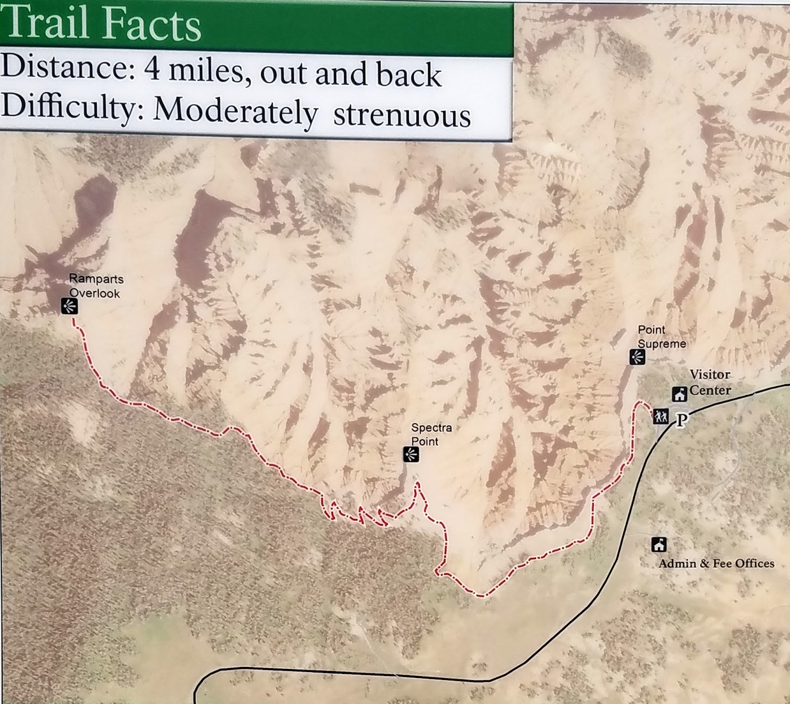 |
| Cedar Breaks - Spectra Point & Ramparts Overlook Trails Map |
 |
| Cedar Breaks Spectra Point Trail |
 |
| Cedar Breaks Spectra Point Trail |
It was 51 degrees
with an elevation of over 10,000 feet at 12:40 pm. The trailhead is located just south of the Information
Center parking lot. The trail climbs and descends for one mile to
Spectra Point.
I continued down a
series of six switchbacks before leveling out for another one mile hike to Ramparts
Overlook.
Lots of flowers
along this trail and down where the water flows. The trail took me 2 hours and 10 minutes to
hike.

 |
| Bristlecone Pine |
 |
| This is Spectra Point from Ramparts Overlook Trail |
 |
| Cedar Breaks Ramparts Overlook Trail |
I saw a
playful, reddish marmot who appears to
be living under a small cabin – all that remains of the Cedar
Breaks Lodge.
 |
| Alpine Pond Trail Lower Trail |
 |
| Alpine Pond Trail #12 without a trail guide the numbers are uselessl |
 |
| Alpine Pond Trail Alpine Pond on the Lower Trail |
 |
| Alpine Pond Trail - Wildflower Festival The flowers were in season |
The trail and an Upper and Lower Branch. I parked at the Winter
Ranger Station parking lot and
took the Lower Trail past Alpine Pond to the Chessman Ridge Overlook. I returned via the Upper
Trail, without going
down to the pond and returned to the parking lot. This trail took just a little over an hour to
walk. The Lower Trail takes about 40 minutes because
of the descent and the climb back up. The Upper Trail is fairly level.
SATURDAY July 2, 2016
WEATHER: 62 at 5 am - in the 70's at Great Bsin, in the 80's when I returned to the KOA
Cedar City EL 5846’ Sunrise 6:15 am Sunset 8:58 pm
TRAVEL: Cedar City KOA to Great Basin National
Park to Cedar
City, UT
 |
| This is a good map of the area. Great Basin, Death Valley, Mojave, Grand Canyon Byrce, Zion Capitol Reef Lake Mead, Wupatki, Sunset Crater, Walnut Canyon, Kings Canyon, Sequoia, Yosemite, |
316 GREAT BASIN National Park, Baker, NV
Great Basin National Park is located in
White Pine County in east-central Nevada, near the Utah border. The park was
established in 1986.
This
was a 140 mile 2 ¼ hour drive west of Cedar City, UT. An interesting drive across 3 mountain ranges
and 3 wide valleys. There is not much
out west and not much traffic. I
literally had the road to myself on the way out. I left at 7:30 am and arrived a 9:15 am. Nevada is on PDT so I forgot
that I gained an hour. I had registered
on-line for a noon Lehman Caves tour with a ranger.
 |
| Great Basin NP - I only saw a little of this entire park - of course most of it is wilderress |
 |
| Lehman Caves |
 |
| Lehman Caves |
 |
| Lehman Caves |
I
didn’t plan on doing any hiking and really didn’t have the time but I did take
the Scenic
Drive to the end of the road near Wheeler Peak. There are
three trails at the end of this drive:
 |
| Great Basin - Mather Overlook |
Wheeler Peak Trail – Strenuous,
8.2 miles round-trip; with an elevation gain of 2,900 feet.. It starts at EL 10,160’
Bristlecone Trail – Moderate, 2.8
miles round-trip; with an elevation gain of 600 feet. It starts at EL 9.800’.
Alpine Lakes Loop Trail – Moderate; 2.7
miles round-trip; with an elevation gain of 600 feet. It starts at EL 9,800’
There
are numerous other trails in the park that are not mentioned on the park’s
website. Additionally, there are two Visitor Centers – one in Baker and another at
the entrance to Lehman Caves.
This is also not mentioned on the website.
There was no parking at the end of the Scenic
Drive for the
trail-heads. I did stop at the Mather and Wheeler Peak Overlooks.

The observatory is a cooperative effort including the NPS, the UN- Reno; Western Nevada College and Southern Utah University. NPS offers astronomy programs. This year’s astronomy festival is 9/29 – 10/1 2016.
 |
| Great Basin Lehman Caves map |
 |
| Great Basin Lehman Caves |
Lehman Caves is actually one cave. Until I looked at the website I didn’t know there was a
cave – it appears to be the major draw. There is a charge for the tour. The cave extends ¼ mile into the base of the Snake Range. A miner/rancher named Absalom Lehman explored the cave in 1885. It has many, many formations – I think some of the best I’ve seen – not a Mammoth Cave (KY) or a Carlsbad Caverns (NM) but a good cave tour. It has some familiar formations such as stalactites, stalagmites, columns, draperies, flowstone, and soda straws - - - it also has shields. I’m glad I took the tour.
There are also plenty of campsites
in the park. If camping and hiking you
can spend several days here.
 Christ the King Church is in Cedar City,
UT. By the appearance of their webpage
the priest says mass in 3 other cities. Saturday
evening AT 5:30 and 9 am Sunday morning here in Cedar City; St. Getrude’s in Panguitch at 1:30 pm and St. Sylvester’s in Escalante on the 2nd & 4th
Monday at 6 pm.
Christ the King Church is in Cedar City,
UT. By the appearance of their webpage
the priest says mass in 3 other cities. Saturday
evening AT 5:30 and 9 am Sunday morning here in Cedar City; St. Getrude’s in Panguitch at 1:30 pm and St. Sylvester’s in Escalante on the 2nd & 4th
Monday at 6 pm.
 313 ZION National Park, UT
The trail was
blasted out of the cliff-side by the Civilian Conservation Corps in the 1930’s. It’s a 2 mile hike just to get to Scout’s Lookout.. The 1,050 foot climb in 2 miles is equal to
an average 10% grade. Just to get to Timpanogos
Cave is a 2 mile paved
walk with a 16% grade and most trails in the Grand Canyon are steeper . . .
From junction at the West Rim Trail and the start of the Angels Landing, it is another ½ mile to the summit of Angel’s Landing. This is a steep climb up the side of a cliff – mostly using chains for balance and people are using the one-way trail both ways at the same time. To tell the truth it was a bit scary and crowded even at 9 in the morning. I went about as far as I could/wanted to go and decided not to personally visit the angels today. From Scout’s Lookout it may be best not to have a pack and have both hands free. I was carrying a walking stick that was more of an encumbrance than help. The gloves I carry in my pack were useful along the rock walls and chains.
Angel’s Landing itself rises a sheer 1,500 ft above the north fork of the Virgin
River. I should have continued on the West
Rim Trail to the West
Rim Viewpoint – this wold have
been another 4.8 miles which would have turned this into a 13.6+ mile hike – it
was only 9:15 am but I started back down. I had hoped to walk the Hidden
Canyon Trail at Stop 7
Weeping Rock.
SUNDAY July 3, 2016
WEATHER: 66 at 5 am, clear, rain &
thunder started around 11:15 am one small storm after another – at times heavy
rain and thunder – localized – such is to be expected in the West.; 2 pm 65
with rain and thunder; and then there
was hail (rock salt size);
Cedar City EL 5846’ Sunrise 6:16 am Sunset 8:58 pm
TRAVEL:
Cedar City KOA to Christ the
King Church back to the KOA

The church was much larger than expected – there must have been 200
people at mass – mostly Caucasian – 1 black – 1 Asian family and only 1
Hispanic – a man studying to be deacon.
A good choir – 7 miked singers, 2 guitars, flute, violin and an
organ. Amazingly they all complimented
each other instead of one instrument of voice dominating. There was no apparent “director” but the
arrangements were subtle enough to speak professional.
The pastor was just a little bit too much ‘holy’ in his speech,
mannerisms and in his homily. At one
point when he stood up I thought he would literally float on clouds to the
altar. He attempted to bring the readings together with the holiday and I think
he became too political from the pulpit. He took a swipe at “cafeteria catholic’s”
and spoke that the sanctity of marriage, abortion and freedom of religion were
not all the issues . . . . then he got
into independence which is not a Catholic Value and dependency . . . he should have just’ let it go’...
Just before and after mass I stopped into the local McDonald’s and was rewarded with a WIFI that was amazingly fast. I updated the blog and posted photos through
June 30th. Then around 11:30 it started
to rain and thunder – something tells me that walking is a canyon bottom along
a “river” is not going to be a good thing to do today.
The ‘weather’ stayed around until 3:15 – the sun was out by 4
MONDAY July 4, 2016
WEATHER: 66 at 4 am
Cedar City EL 5846’ Sunrise 6:16 am Sunset 8:58 pm
TRAVEL:
Cedar City KOA to Zion NP to Zion HD to Zion NP-Kolob Canyons VC to Cedar City KOA

Angel’s Landing Trail: this trail is termed strenuous because of the sheer
drop-offs and chains that you should use in order to keep from falling off the
cliff, that’s in addition to the 1,050 ft climb from the Grotto picnic area (Shuttle Bus Stop
6).through Refrigerator Canyon and up Walter’s Wiggles ( 21 closely spaced switch-backs) to Scout’s Lookout just to get to the start of the Angel’s
Landing Trail. Most of the trail to Scout’s
Lookout is paved but still
a tough climb . . . .
 |
| West Rim Trail Refrigerator Canyon |
From junction at the West Rim Trail and the start of the Angels Landing, it is another ½ mile to the summit of Angel’s Landing. This is a steep climb up the side of a cliff – mostly using chains for balance and people are using the one-way trail both ways at the same time. To tell the truth it was a bit scary and crowded even at 9 in the morning. I went about as far as I could/wanted to go and decided not to personally visit the angels today. From Scout’s Lookout it may be best not to have a pack and have both hands free. I was carrying a walking stick that was more of an encumbrance than help. The gloves I carry in my pack were useful along the rock walls and chains.
 |
| Scout's Lookout Trail Junction |
 |
| Angel's Landing Trail Can you see it? |
 |
| This is Angel's Landing I am half-way up the trail It continues along the narrow ridge on the right of the picture. Can you see the people? |
 |
| West Rim Trial Walter's Wiggles 21 switchbacks in this stretch alone. |
However, when I got
to Weeping Rock the Hidden Canyon Trail was closed for repair until September 1st. I probably saw the
sign last week but just didn’t remember . . . . I took the shuttle back to the VC and drove to Zion-Kolob
Canyons. I was tired it was in the upper 80’s and I
decided not to walk the Taylor Creek Trail which I had planned to walk yesterday but the storms interrupted my
plans.
TUESDAY July 5, 2016
WEATHER: 68 at 4:30 am
Cedar City EL 5846’ Sunrise 6:16 am Panguitch, UT EL 6624’ Sunset
8:55 pm
TRAVEL:
Cedar City KOA to Hitchin’Post
RV Park, Panguitch, UT to Bryce Canyon NP to Panguitch, UT
I’m updating the blog through July 4, 2016 at my favorite McDonald’s in Cedar City, UT (it may be the only McDonald’s)
because the WIFI at the Cedar City KOA will not allow
uploads or attachments to e-mail – of no use to me - a fine RV Park but it would rate a 5 of 10
because of the WIFI.
Called AKickin’ Tire & Auto to check on the status of my RV repair – of course
there was no answer when I’m done here I’ll drive over and pay a personal
visit. It' not repaired they processed a refund.
315 BRYCE CANYON National Park, Hwy 63, Bryce Canyon, UT
I had done a recon on Friday July 1 and a return to Cedar City from Zion – so I went directly to Visitor Center, checked with a ranger about trails, caught the shuttle to Inspiration Point (Bryce Point is closed due to a spring washout until at least September).
RIM TRAIL from Inspiration Point (EL 8120’) to Sunset Point (EL 8000’) - the trail is .7 mile paved. It serves as a cross county ski trail in the winter.
RIM TRAIL from Sunset Point (EL 8000’) to Sunrise Point: ½ mile paved trail; The Navajo Loop trail-had is at Sunset Point.
Sunrise Point is also the trail-head for the Queen’s Garden Trail.
I got back in my
car and drove to the end of the 18 mile Scenic Drive and hiked the 1.0 mile Bristlecone
Pine Trail. This trail starts at Rainbow
Point (EL 9115) has leads to Yovimpa
Point with a return to the parking lot at Rainbow
Point. It has an elevation change of 200 ft.
On the return to Panguitch, I drove east on UT 12 to the Mossy Cave trailhead.
MOSSY CAVE TRAIL: .8 mile round trip, from EL 6920’ to EL 6827’ (98’) A streamside walk up to a mossy overhang and a small waterfall.
315 BRYCE CANYON National Park, Hwy 63, Bryce Canyon, UT
0700 Queens Garden Trail: .8 mile one-way descent of 357’
from the trailhead at Sunset Point. Unfortunately, I did not take the short spur
to the 0720 Queen Victoria (EL 7660’) formation.
0800 a short walk to the
base of the Peekaboo Loop Trail (EL 7390).
The Peekaboo
Loop Trail is at EL 7390’ in
the canyon and climbs to EL 8000’ (610’). A steep hike to the top.
The Peekaboo
Loop Trail is divided into 2
sections. I walked the 1.3 mile spur
arriving at the junction (EL 7720) of the trail to Bryce Point at 0845.
The 1.7 mile hike back to the base is both up and down. I arrived back at the base of the trail at 0940.
Again walked the
short trail to the base of the 0950 Navajo Loop Trail (EL 7480) an up the .7 mile Wall Street Loop. This last part of the trail was a steep climb with switchbacks that I believed steeper than those in Walter’s Wiggles on Zion’s Angel’s Landing Trail. Navajo Loop Trail is at EL 7475’ in the canyon and goes up to the rim EL 8000’ (525’ up) and continues a short way along the Rim Trail to a descent back to EL 7475’ in the canyon. Easy walk down – real tough going up. I arrived at the Navajo Loop Trail-head at 1025 and walked the ½ mile back to my truck parked near Sunrise Point.
.
RED CANYON: I made another stop at the Visitor Center. There are plenty of trails in the Red Canyon
area of Dixie National Forest.
THURSDAY July 7, 2016
Left Panguitch at 0545; arrived at Bryce Canyon entrance 0625; arrived Rainbow Point parking lot 0640 and at the walked to the Riggs Spring Loop trail-head. Started the trail at 0650.
315 BRYCE CANYON National Park, Hwy 63, Bryce Canyon, UT
The RIGGS SPRING LOOP TRAIL was the volunteer I talked to on Tuesday favorite trail. It not specifically mentioned in the park newspaper but it does appear on the maps. She indicated that I would see few, if any people on the trail. I thought I’d give it a try. It was described on the same sign as the Bristlecone Trail that I hiked on Tuesday afternoon.
I did buy a map a National
Geographic map of Bryce
Canyon The map has topographic detail of the park to
include this trail. It is broken into
several segments.
1.6 miles Riggs
Spring along Mutton Hollow to Corral
Hollow Campground
3.6 miles Corral
Hollow up The
Promontory to connect back
with Under the Rim Trail, back to Bristlecone Loop Trail and the parking lot at Rainbow Point.
Looks like 8.3+ miles – that will be enough for today. It took me 5 ½ hours. Started down the trail at 0720 and got back to the top at 1240.. This trail is mostly wooded and may be the best trail I've walked. Solitude - except for a few guys just waking up at Yovimpa Pass Campground didn't see any else on the trial.. The climb from Corral Hollow Campground was uphill all the way.
FRIDAY July 8, 2016
TRAVEL: Hitchin’Post RV Park, Panguitch, UT to Wonderland Resort & RV Park, Torrey, UT to Capitol Reef NP to Torrey, UT
Scenic Byway 12 spans a route of 124 miles from Panguitch to Torrey,
Utah. Torrey is my next RV stop.
The Waterpocket Fold is a 90 mile long monocline in the Earth’s crust. A monocline is a fold in the Earth’s crust where one (mono) flank of the fold is steeply inclined, the other is nearly flat.
The Waterpocket
Fold began forming
between 50-70) million years ago (Cenozoic Period)
in response to the North American Plate’s westward movement over the Pacific Plate. Tectonic stresses passing far inland from the actual collision zone of the plates resulted in faulting and folding of the Capitol Reef Area.
Utah Highway 24 crosses about 15
miles of the park from east to west. The
remaining the 65 north-south miles is either inaccessible by road or there are some
dirt roads that run on the uplifted part of the Waterpocket Fold on its east side. I plan to take the Norton-
There are over 140
miles of roads in and around the park and over 150 miles of trails and
backcountry routes for the hiker and backpacker.
STOP 2 – Creation of the
Waterpocket Fold. The
rugged western escarpment of Capitol Reef tells the essentials of a complex story. Rock
bands of differing thickness, colors, and textures lay one upon another like
layers of a cake. The rocks of Capitol Reef were once sediments (silt, sand, clay, and
gravel) laid down in many different environments during the past. Younger rocks
lie on top of older rocks.
Stop 7 - Slickrock Divide separates two large
drainages. To either side of this hill, streambeds channel rain runoff and
debris into Grand Wash to
the north, and Capitol Gorge to
the south. When rain does come to Capitol Reef, it often descends in
torrents. Large expanses of bare rock and thin patches of soil can do little to
absorb and hold it.
Stop 9 - The
Capitol Gorge
spur Road is longer and more winding than Grand Wash. Although a through road
from 1884 to 1962, the drive now ends in a few miles.

Stop 10 - The Navajo Formation, over 1,400 feet (427 m) thick in places, caps the upper reaches of Capitol Gorge. Its white, rounded domes, reminiscent of the nation's capitol building, inspired part of the name for Capitol Reef. Prospectors with seafaring experience viewed this monocline as a barrier to transportation, and supplied the nautical term "reef".
 CAPITOL GORGE TRAIL – a 2 mile round trip down and up Capitol Gorge and an 80’ climb/scramble
up to view The Tanks. This last part of the trial is not well
marked but an interesting climb. Going
up was easier than coming down – I lost the trail twice. This was a 1 hour 15 minute walk.
CAPITOL GORGE TRAIL – a 2 mile round trip down and up Capitol Gorge and an 80’ climb/scramble
up to view The Tanks. This last part of the trial is not well
marked but an interesting climb. Going
up was easier than coming down – I lost the trail twice. This was a 1 hour 15 minute walk.
Dune
lines in Navajo Sandstone walls
evidence ancient landscapes and sediments that became rock. Rounded domes and
deep canyons demonstrate the power of erosion. The rapid sequence of rock
layers along the fairly level Capitol Gorge spur road confirms the tilting and
bending of the Waterpocket Fold.
Geology creates the foundation for human habitation. Worn petroglyphs can be seen after a short stroll into Capitol Gorge. Prehistoric people of Fremont Culture used area rock for tools and projectile points, and for the foundations of their homes. Clay was used for pottery, construction and to make figurines. Fertile floodplains supported crops of corn, beans, and squash along the streams of Capitol Reef until about 1300 BC.
Mormon
pioneers took eight days in 1884 to clear the first road through the Gorge, and settlers had to
remove heavy debris after every flash flood. Early travelers recorded their
passage on the canyon walls at the Pioneer Register. The road was closed in 1962
when Utah Highway 24 was paved through the Fremont River corridor.
Fremont River Trail: I joined a ranger-led “geology” hike on the Fremont
River Trail. The ranger was a geologist and very
knowledgeable of the terrain. There were two other rangers – on their ‘day off’
– who joined the walk along with two other couples who has heard this ranger
give a talk last night.
The ranger had an interesting approach. He had several clipboards with a sheet of paper on them for Field Notes – he turned this into a geologic notation trip – on the sheet of paper there was a heading for today’s data and additional headings labeled Moenkopi; Black Boulders, Chinle ad Erosion and Uplift. The hike was an ongoing outdoor lecture with the rocks in view – much better than a sit-down lecture.
STOP 3 - The twisting Grand Wash
spur road takes you into a landscape dramatically different from the dark red
hills along the base of Capitol Reef. Grand Wash is a narrow, steep-walled
canyon subject to dangerous flash floods that often arrive with little warning.
Avoid canyons and washes when storms threaten.
STOP 4 – Cassidy Arch. This is a short trail to a viewpoint where
you can see the Cassidy Arch. The two rangers who were on the geology hike
pulled up behind me. They planned to explore
the canyon to the right. I did not walk
to the viewpoint deciding to walk the Cassidy Arch Trail. The massive, sheer cliffs of Wingate Sandstone have sweeping lines that intercept
one another at varying angles in the rock. Large scale crossbedding indicates
windswept drifted dunes of an ancient desert.
CASSIDY ARCH TRAIL: 3.4+ mile round trip with
either a 670 or 1,050 change in elevation – depending on which source you want
to believe. I can tell you it was uphill all the way. Somewhere along the way the trail connects with
the Frying Pan Trail
and there is supposedly a turn-off to the Cassidy Arch. Somehow, I missed the trail to the Cassidy Arch. I continued to climb and found out that I had
missed the turn-off for the Cassidy Arch and has followed to Frying Pan to its summit.
Just below the summit of the Frying Pan Trail I ran into a woman and here
granddaughter who asked me how far it was to the Cassidy Arch Trail. This is where I discovered I had missed the
turn-off myself. I was already on the
trail for 1 ½ hours and probably had
walked 3 miles – long past the turn-off for Cassidy Arch.
Walked the short 0.8 mile round trip Sunset Point Trail and ¼ mile Goosenecks Trail.
This is Mormon country,
Torrey does not have much but it does have The Church of Jesus Christ of the
Latter Day Saints. I found St.
Elizabeth’s Mission
Church in Central Valley,
UT as being the closest Catholic Church.
A 72 mile one-way, 1 hour and 20 minute drive, St. Elizabeth’s has a Sunday Mass at 9 am. Near Richfield, UT and along I-70 –
civilization.

It was somwehere around 26 miles to the Cathedral District which is at the north end of the park via the dirt Cathedral Road (2 hours). Here there was a climb to the Cathedral Valley Campground. The view on the road to the top made the 3 hour trip worthwhile. I decided to take the dirt Hartnet Road back; an addtional 36 mile 2 hour trip.
Neither the Cathedral or Hartnet Roads should be driven during a rain or just after a rain – like switchbacks on a hiking trail, I lost count of the washes I crossed.
The Hartnet
is lower and would
be extremely muddy. The drive down from
the campground took 2 hours and a short delay when I reached a ford at the Fremont
River. Unsure of the depth, I walked across. It looked deeper but was just over the ankle deep. A high clearance vehicle is advisable for
this dusty adventure. I think I’ll let some pictures tell the story.
MONDAY July 11, 2016
317 CAPITOL REEF National Park, UT 24, Torrey, UT
SURPRISE CANYON TRIAL – The 2 mile round-trip trail crosses a broad-grassy drainage before entering a deep canyon the Waterpocket Fold. After crossing the dry wash bed of Hall’s Creek, the trail turns left to the crest of a small grassy hill.
TUESDAY July 12, 2016
MOAB KOA: WIFI works sometimes - at least this placed has some shade - temperatures in Moab are usually in the 90's to 100's. A lot of dust, ants - learned that some ant granuels work well on the anthills - keeps them from hitch-hiking into the trailer - this is the high desert. Arches is a 20 minute drive down the road - I passed the entrance on the way into Moab.
Moab has an overabundance of hotels/motels, restaurants, and outfitters - seems like this is also a high adventure/mountain bike destination - way too many tourists . . . .
318 ARCHES National Park, Moab, UT
Moab Fault –
the geology here is impressive. A fault is a fracture surface in the rocks
along which the rocks on one side have moved relative to the rocks on the other
side. The total displacement is about
2,600 ft. The rocks on top of NE side of
the fault were deposited during the Jurassic
period about 150 million years ago. The
rocks on the top of the SW side were deposited during the Pennsylvanian
period about 299 million years ago.
Park Avenue
Viewpoint and Trailhead – Park Avenue
was named because it resembles the narrow streets of New York.
La Sal
Mountains Viewpoint – The La Sal Mountains
are not located in Arches NP, but can be
seen from many points in the park. The
12,000 foot mountains form a background
– At 12,721 feet, Mt. Peale
is the highest point in the range. The
mountains are not volcanoes but the remains of an igneous formation that
intruded into older rocks. The
sedimentary rocks weather more easily, so through time, the sedimentary rocks
weathered leaving the exposed igneous – the La Sal Mountains.Courthouse
Towers Viewpoint –
Petrified Dunes Viewpoint - Windblown sand
dunes covered much of the Southwest during the Jurassic
period (170 million years ago). The
dunes were eventually buried and cemented with calcite and quartz turning the
dunes into sandstone. As the Colorado Plateau
uplifted and the overlying rocks eroded, the Navajo Sandstone
was exposed.
Garden of Eden is composed of numerous pinnacles with a few small windows and arches. Joints separate the rocks into closely-spaced towers. Weathering contributed to the rounded appearance of the sandstones and siltstones.
DEVILS GARDEN TRAILHEAD
DOUBLE O ARCH TRAIL 4.2
miles round trip (Landscape Arch
Trail included in total)
Tunnel Arch – the trail here ended at wood fences – expecting to see an arch ahead
there was none – I had to look right – it is not intuitive and there is no
sign. The Tunnel Arch is actually a “window”. A window is still an arch, but geologists
say that if the opening is well above ground it is a “window”. However, “tunnel seems appropriate. The opening is nearly circular with a height
of 26 ft and a width of 24 feet. The
arch is formed completely within the sandstone of the Slick
Rock Member of the Entrada
Sandstone.
Landscape Arch – is the longest arch span in the park and one of the largest in the
world. The arch is 291 feet across, 3 ft
larger than the Zion Arch. The arch is very fragile. The upper part of the arch is very thin – at
most 6 ft thick. Thin slabs are peeling
away . Three large slabs has fallen
since 1991. It may not have many more
years as an arch. It is not orange-red
like other arches in the park, indicating that the sandstone does not contain
much iron-oxide.
Fin Canyon – is an example of
several stages of arch formation. The
long NW-SE trending fins in the Slick Rock Member of the Entrada
Sandstone form closely
spaced walls of rock. The narrow canyons
between the fins are a result of weathering and erosion along the joints.
Double O Arch – pairs of arches are common but it is rare to find one on top of
another. The larger top arch is 35 ft
high and 67 ft wide. The relatively flat
top show few joints. The lower arch is
much smaller, about 9 ft high and 21 ft wide.
Partition Arch – is unusual in that it appears to be a single arch opening but just off
center is a pedestal. The pedestal
almost appears molded as though holding up the arch. There is desert varnish – black and brown
stains on the upper and lower edges of the sandstone.
BROKEN ARCH TRAIL from the Sand Dune Arch trail head. This trail is 1.3
miles roundtrip.
 Canyonlands offers a wilderness of countless canyons and
fantastically formed buttes carved by the Colorado River and its
tributaries. Rivers divide the park into four districts: the Island in the Sky, the Needles, the Maze,
and the rivers themselves. These areas share a primitive
desert atmosphere, but each offers different opportunities for sightseeing and
adventure.
Canyonlands offers a wilderness of countless canyons and
fantastically formed buttes carved by the Colorado River and its
tributaries. Rivers divide the park into four districts: the Island in the Sky, the Needles, the Maze,
and the rivers themselves. These areas share a primitive
desert atmosphere, but each offers different opportunities for sightseeing and
adventure.
The centerpiece of
the Canyonlands National Park is the confluence of the Colorado and Green Rivers. The ”Y” shaped river system divides the park in 3 regions/districts.
In the north between the converging courses
of the Green & Colorado Rivers lies the upland plateau district known as the “Island
in the Sky”. It is home to the Upheaval
Dome and is accessible
by paved road, jeep trail, or on foot.
Fins, arches, and spires sculpted from the Cedar Mesa form the “Needles” district located in the southeast corner of the park.
It is unfortunate that Mesa Arch Trail (1/2 mile), Buck Canyon Overlook, Orange Cliffs Overlook, Aztec Butte Trail (2 miles) and Upheaval Dome Trail (.8 mile) were all closed due to paving. I may return on Sunday and also hike a portion of the Lathrop Trail (2 miles) and the White Rim Overlook Trail (1.8 miles). There may not be enough time in the day and still make a tee time of 5 pm.
I checked out the Moab Golf Club and made a Sunday tee time for 5:16 pm.
FRIDAY July 15, 2016


319 CANYONLANDS National Park, Moab, UT “The Needles Unit”
The Needles offers of 60 miles of interconnecting trails, challenging and rewarding. I planned to only walk some of the shorter – maintained trails.
ROADSIDE RUIN TRAIL – 0.3 miles a short trail that leads to an Ancestral
Puebloan granary. The was
short Nature Trail with a Trail Guide available. This trail took 10
minutes to walk.
CAVE SPRING TRAIL - a one mile dirt road leads to a 0.6 mile trail. This is another short loop trail to a historic cowboy camp and prehistoric pictographs. There are two ladders on the route. There was a Trail Guide available.
In the late 1800’s pioneering cattlemen settled in canyon country. John Albert Scorup was one of the best known. He was able to establish a successful cattle operation. In 1926, Scorup and his partners formed the Scorup-Sommerville Cattle Company, which eventually grew to be the largest in Utah. Their herd varied from 7,000-10,000 head and ranged over 1,8 million acres.
POTHOLE POINT TRAIL – a 0.6 mile loop on uneven slick rock to potholes as well as views of the Needles – the trail follows cairns. The rock surface along Pothole Point Trail is Cedar Mesa Sandstone. Cedar Mesa Sandstone is from the Permian Period (245-286 million years ago). It is part of the Cutler Group which is underneath the Moenkopi Formation. Cedar Mesa Sandstone is the dominant layer within the Needles. It is capped by Organ Rock Shale and White Rim Sandstone – beneath the Cedar Mesa Sandstone is Halgaito Shale of the Elephant Canyon Formation.
Because the rock is not uniform in how it was laid down, it has not eroded evenly. Once started, a pothole continues to grow larger. It becomes a trap for windblown sand grains and pebbles which scour the hole deeper. Rainwater which normally contains a weak carbonic acid collect in the depressions and continues to dissolve the cementing material. There was a Trail Guide available. This trail took 15 minutes to walk.
SLICKROCK TRAIL – a 2.4 mile loop with a geology guide.
This trail did not have Trail Guides available. The trail is marked by cairns.
The trail to Viewpoint #4 is poorly marked – in fact
there are several trails – it is confusing.
I spoke to a ranger at the VC about this and she confessed
that “it needs to be re-cairned – maybe
in the fall.” Well, that’s too late
for the summer visitors. It would have
been helpful to know what you were looking at from the Viewpoints
if a Trail
Guide was
available. This trail took 2 hours and
10 minutes to walk – something tells me I walked more than 2.4 miles.
SATURDAY July 16, 2016
DELICATE ARCH TRIAL is a 3 mile round trip to the park’s best know arch.
. . .
and even arriving at 6:45 am – “’too many people.’ It is
the one most associated with Arches NP. This is
considered a difficult trail with an elevation change of 480 feet. The first half is easy then it turns to slick
rock and you have to follow the cairns.
Just before getting to Delicate Arch there is a narrow rock ledge for 200 ft.
AZTEC BUTTE TRAIL is a 2 mile round trip trail. The trail starts out following a sandy wash, then ascends to Aztec Butte which requires some scrambling up slick rock and ledges. It took 55 minutes to walk this trail.
UPHEAVAL DOME TRAIL – this trail has 2 parts. The
hike to the First Overlook is a steep is 0.8 miles round trip. The hike to the Second Overlook adds
another mile to the hike. It took me
just under an hour to walk the 1.8 mile round trip.

5
pm Mass at St. Pius X Church, Moab, UT. Interesting – no
servers – no music – no organ – no choir – no PA (that worked) . You could hardly- The reader I actually hear the reader, I
though the priest had fallen asleep -
there was such a delay between finishing the readings and gospel - - - -
- the homily was good – pay attention to guests . . . . . don’t worry about the
little things. About 100 people in
attendance.
DOUBLE ARCH TRAIL is a ½ mile round-trip. It is
unusual for a pair of arches to be so close.
The SE arch is the second largest arch in the park; it is 105 ft high
and spans 160 feet. The W arch is
smaller with a height of 61 ft and a
width of 60 ft. The origin of the Double
Arch is thought to have
been formed by water erosion from above.
Gravity does not play a role in the continuing development of
arches. The top of the larger arch shows
signs of thinning. The smaller arch has
a very thick crown, but the rectangular gap suggests that a very large block is
missing – it fell in the not too distant past.
INDOWS TRAIL is a 1 mile round trip with a gentle climb to the North
Window, South
Window and Turret
Arch.
After Arches I stopped by the Moab Brewery for dinner. I was trying to avoid this place but the food was good, the beer was cold and the prices was very reasonable. However, I’m glad my time in Moab (6 days) is coming to an end. There is plenty to do here – I mentioned there were a lot of outfitters – both the Colorado and Green Rivers come together near here – John Wesley Powell called it “the Cataracts”. I never even explored white water rafting. Moab is way too hot and there is too much machismo - bikers (not Harley) – hikers – more bikers – thrill seekers – ATVers, cross country cyclists - an endless supply of young sports enthusiasts and old guys who work out in gyms and stay out in the sun – I figured it out - these folks are Californians - and then there are the TOURISTS – I probably see more people from Europe on the trails than from the US. The number of people at Arches reminded me of Acadia - only there were more bikers/cyclists and people at Acadia. Going to Colorado National Monument tomorrow and heading east into Colorado on Monday. Time to leave the “high desert.”
 320 COLORADO National Monument, Fruita, CO
Saddlehorn Visitor Center - a nice VC with 2 videos,
exhibits and a bookstore - helpful and
friendly ranger and volunteer. I watched one that was a 15 minute slide show
with narration about Colorado NM and another 10 minute video about it’s geology.
Alcove Nature Trail is
a 1 mile round trip that starts across the road from the Saddlehorn Visitor
Center. A trail guide is available from the VC. EL 5,800’. It is
mostly level trail that leads to an alcove in a box canyon. A good introduction to some of the plants,
animals, and rocks of the monument. Great for families with small children.
Otto's Trail
Coke Ovens Trail
Got back in time
for a 4:30 pm tee time at Moab Golf Club.
I played 9 holes. The course is
in fantastic shape for being in the middle of the desert - it was 100 degrees. Some great views – not a very long course but
tight and it took me awhile to understand that all the greens slope to the
front. I shot a 48 with 3 lost balls and
3 putts on 5 holes. I was hitting the
ball well – drives were fairly straight and the rest of my clubs were hitting
true i.e. a well hit 8 iron went 120 yds; a 5 wood sailed 175 yds. That hasn’t happened in a long while – maybe
it’s the 4000’ elevation. Shots over the green caused the 3 lost balls
and 3 strokes I had fun – even in the
heat.
321 BLACK CANYON OF THE GUNNISON National Park, Montrose, CO
 My first stop was at Tomichi Point. The Gunnison
River was called the Tomichi before
it was named in honor of CPT John W.
Gunnison, who led an 1853 search for
a Pacific railroad passage between the 38th and 39th
parallel. The survey party circumvented
the deep gorge – the Black Canyon - which they deemed impenetrable. Gunnison
was killed later that year by a band of Paiutes
My first stop was at Tomichi Point. The Gunnison
River was called the Tomichi before
it was named in honor of CPT John W.
Gunnison, who led an 1853 search for
a Pacific railroad passage between the 38th and 39th
parallel. The survey party circumvented
the deep gorge – the Black Canyon - which they deemed impenetrable. Gunnison
was killed later that year by a band of Paiutes
The Visitor Center was my second stop but before entering I walked to Gunnison Point. The canyon is spectacular a drop of 1800-2000 ft.
The Visitor Center has some displays a 20 minute video and a bookstore. – friendly rangers. There is little evidence of even the Paiute living on the rim let along in the canyon . . . . .
There are several overlooks on the south rim and 4 trails. I drove as far as the Pulpit Rock today and plan to walk the trails and complete the South Rim tomorrow.
TUESDAY July 19, 2016
321 BLACK CANYON OF THE GUNNISON National Park, Montrose, CO
.
Cedar Point Nature
Trail

Warner Point Nature Trail
Moderate - 1.5 miles round trip
There was a trail guide available at the trailhead. Looking south you can see the San Juan Mountain Range and the Uncompahgre Valley. To the north look for the West Elk Mountains, and at the end of the trail enjoy the views of the Gunnison River and the Black Canyon. This trail took about 50 minutes to walk.
Rim Rock Nature Trail
Moderate - 1 mile to the Uplands Trail junction from the VC
I joined the geology ranger for a walk that took us to Timichi Overlook. It was an interesting walk – I learned a few things and there were some kids and older “sharpshooters” on the walk. His approach was teaching and learning with examples of rocks, pointing out native flowers and a sort of final exam puzzle picture of how the Gunnsion Canyon formed over time. I’m glad I joined the group.
This trail has many excellent views of the Gunnison
River as well as the sheer walls of the canyon. The trailhead is near the entrance to
Campground Loop C and ends at the South Rim Visitor Center – I walked it in reverse to
the junction with Uplands Trail.
Oak Flat Loop Trail is
described as a strenuous 2 mile round trip trial. It starts at the VC and was built by the Student Conservation Association (SCA) volunteers. The trail meanders through a thicket of oak
scrub (Gambel oak) passing near a rock outcrop.
The trail then heads west where it begins its ascent through a forest of
Douglas fir, Aspen, and Gambel oak. On the return leg one encounters another
unmarked overlook offering spectacular views downstream. The elevations change is 400 feet.
322 CURECANTI National Recreation Area, Montrose, CO
The high dry eroded
vistas are interrupted by the Gunnison River and three reservoirs: Blue
Mesa, Morrow Point, and
Crystal Blue Mesa. Blue Mesa serves as the main storage
reservoir. Morrow
Point Dam generates most of
the power, and Crystal Dam maintains an even flow through the Black Canyon of the Gunnison.
My plan is to visit
Curecanti NRA walk some trials and continue on to the North Rim of the Black
Canyon of the Gunnison NP – walk some trails
and continue the loop closing with a 2 hour drive back to Montrose and the
KOA.;
There are 7 trails
in Curencanti NRA. They range from 1 ½ mile to 6
miles long.
Pine Creek Trail
A great day trip for Curecanti would be a hike on the Pine Creek Trail with a boat tour; a visit to the VC (not much there), and if really interested in hiking walk the Dillon Pinnacles Trail. Tickets for the boat tour can be purchased at the Curencanti VC. Do this at least a day in advance. They may be offered on line.
321 BLACK CANYON OF THE GUNNISON National Park, Montrose, CO
NORTH RIM
Chasm View Nature Trail
Moderate - 1/3 mile round trip
This trail is located at the end of the one-way campground loop. After a short distance, the trail breaks out of the pinyon/juniper forest at the North Chasm View, some 1800 feet above the river. Continuing near the rim, the trail reaches a second overlook with excellent views of Painted Wall and Serpent Point. Keep a lookout for swifts, swallows and raptors frequently seen from this overlook. The Chasm View Overlook on the South Rim is only 1,100 feet away nut it’s a 53 mile drive of 1 hour and 45 minutes to get to the KOA – as the crow flies it was only 11 miles.
There were other trails on the North Rim but I decided not to begin a 3 mile trail at 2 in the afternoon.
FRIDAY July 22, 2016
Four Seasons RV Park: It didn’t look like much – passed right by it and
had to turn around. I wasn’t hopeful . .
. but the WIFI, although intermittent in strength and speed, was more than
adequate. I updated photos to the blog
through last week Saturday . . . there is still a lot to update. If the WIFI slows down, there is a McDonald’s down the road.
SATURDAY July 23, 2016
WEATHER: 61 at 5:30 am – partly cloudy-
323 FLORISSANT FOSSIL BEDS National Monument,
 Florissant Fossil Beds is not an area full of dinosaur bones – the rocks here are much younger
– 34 million years old – at the beginning of the Age of Mammals.
The vast collection of fossils here are of insects and plants.
Florissant Fossil Beds is not an area full of dinosaur bones – the rocks here are much younger
– 34 million years old – at the beginning of the Age of Mammals.
The vast collection of fossils here are of insects and plants. Scientists
pleaded to Congress to protect the fossil beds under federal law. Concerned
scientists, Dr. Estella Leopold and Dr. Beatrice Willard, and citizen Vim Wright emerged as three of the
strongest leaders in the cause to protect the fossils and formed a group called
the Defenders
of Florissant.
Scientists
pleaded to Congress to protect the fossil beds under federal law. Concerned
scientists, Dr. Estella Leopold and Dr. Beatrice Willard, and citizen Vim Wright emerged as three of the
strongest leaders in the cause to protect the fossils and formed a group called
the Defenders
of Florissant.
The
people that favored protecting the area had us and future generations in mind.
They knew that for thousands of years humans had marveled at the impressions of
leaves and insects in stone and tried to make sense of their existence.
Scientists, even from the very first expedition, recognized that this area was
special.
GEOLOGY: A massive volcanic area – the Guffey Volcanic complex – existed 34
million years ago. The eruptions mixed
ash, water and possibly snow to create massive mudflows called lahars.
They conserved today’s Florissant.
Harker Homestead – I stopped here
before the Visitor Center. There was a very talkative ranger here who
provide me with a personal tour of the Harker
Homestead and history. Today was also Junior Ranger Day – there were rangers and
volunteers setting up special exhibits here and at the VC.
Petrified
Forest Loop - 1 mile -This
self-guided trail leads through the beds of ancient Lake Florissant. It passes numerous giant petrified redwood tree stumps, including the colorful "Big Stump". This trail starts
behind the outdoor exhibit area. Signage features the "Walk through
Time" – similar to the geologic walk in time at Grand Canyon on the rim.
The trail is classified as EASY Elevation Change: 65 ft.
Geologic
Trail - 2 mile (round trip)
- This
self-guided trail highlights over a billion years of geologic history in the Florissant Valley. It passes over the ancient lake bed,
crosses Teller County Rd. 1, then ascends past the remnants of a massive
pyroclastic flow and ends at a scenic overview of the Florissant Valley. This
trail is classified as MODERATE Elevation change: 100 ft.
Ponderosa Loop - 1/2 mile - This wheelchair accessible trail starts behind the exhibit area. This self-guided trail enters the modern forest of ponderosa pines, aspen, douglas fir, and spruce trees. This trail is classified as EASY Elevation change: 50 ft.
Cripple Creek, CO EL 9494’ – it was another 12 miles down the road – I had to visit – but was not impressed. There were a number of people portraying the Victorian period – turn of the century. Cripple Creek was known for its gold mines.
Perigrine Pines FAMCAMP: I haven’t
been to the Air Force Academy since 1971, my first AT, fly to Denver, bus to Fort
Carson – straight to
the field, tents in the mountains, the duty was 24 hours a day – we never drew
barracks until the last night when we just slept on mattresses. The Army was different then, Fort
Carson served beer –
on tap - in the mess halls – really – that didn’t last long. We did get a 2 day - 1 night leave (middle
weekend). There were 4 of us, rented a Ford
Pinto, drove to Pike’s
Peak, stayed in
Denver one night, visited Royal Gorge and the Air
Force Academy.
GOLF Eisenhower
Golf Course – USAF Academy – the Blue Course. The USAF Academy has two 18 hole
golf courses. I was lucky enough to get
into a 0708 tee time.
I shot 51 with 23
putts, 3 putted 6 of 9 greens, parred #3 with only 1 putt, landed in 2 sand
traps – good shots out, no lost balls, 1 tee shot landed behind a tree –
chipped to the fairway. The greens were
tough – all sloping – away from the mountains – some were multi-tiered. Overall the course was in good shape. I played with 2 retired AF and one retired AR
gent.

 |
| Map of where I've been and where I'm going Been 2015 Dinosaur, Golden Spike, Timpanogos Cave Been 2016 Hovenweep, Natural Bridges, Glen Canyon, Cedar Breaks, Great Basin Going 2016 Bryce Canyon, Capitol Reef, Canyonlands, Arches, Black Canyon of the Gunnison, Curecanti, Great Sand Dunes, Florissant Fossil Beds, Rocy Mountain, Fort Laramie Going 2017 John D. Rockefeller, Grand Teton, Fossil Butte, City of Rocks, Crater of the Moon |
 |
| Red Canyon |
Hitchin’ Post RV Park: WIFI here works – I
can upload – just for that this place gets 5 *****. Not a large park but very friendly owner and
helpful.
RED CANYON: I drove the 30 miles to Bryce Canyon National Park but stopped at the Red Canyon Visitor Center. Red Canyon is administered by the US Forest Service (USFS) as part of Dixie National Forest. I
was impressed. A good VC with helpful volunteers and surprisingly a very good
bookstore/gift shop. I got some
information on short trails near the VC that I may hike in the following days.
 |
| Inspiration Point, Sunset Point, Sunrise Pont |
I had done a recon on Friday July 1 and a return to Cedar City from Zion – so I went directly to Visitor Center, checked with a ranger about trails, caught the shuttle to Inspiration Point (Bryce Point is closed due to a spring washout until at least September).
RIM TRAIL from Inspiration Point (EL 8120’) to Sunset Point (EL 8000’) - the trail is .7 mile paved. It serves as a cross county ski trail in the winter.
 |
| Inspiration Point |
 |
| Inspiration Point Upper Viewpoint |
.
 |
| Sunset Point Navajo Loop Trail-head |
 |
| Sunset Point view |
RIM TRAIL from Sunset Point (EL 8000’) to Sunrise Point: ½ mile paved trail; The Navajo Loop trail-had is at Sunset Point.
 |
| Sunrise Point Queens Garden Trail below |
 |
| Sunrise Point Queens Garden Trail below |
 |
| Sunrise Point |
Sunrise Point is also the trail-head for the Queen’s Garden Trail.
 |
| Bristlecone Loop Trail Map |
 |
| Bryce Canyon Shuttle Buss |
 |
| Yovimpa Point |
 |
| Rainbow Point |
 |
| Bristlecone Pine |
 |
| Scenic Drive Black Birch Canyon |
 |
| Scenic Drive Agua Canyon |
 |
| Scenic Drive Ponderosa Canyon |
 |
| Scenic Drive Fairview Point |
 |
| Scenic Drive Natural Bridge |
 |
| Bryce Canyon map Location of Mossy Cave |
On the return to Panguitch, I drove east on UT 12 to the Mossy Cave trailhead.
 |
| Mossy Cave Trail Waterfall |
 |
| Mossy Cave Grotto |
MOSSY CAVE TRAIL: .8 mile round trip, from EL 6920’ to EL 6827’ (98’) A streamside walk up to a mossy overhang and a small waterfall.
WEDNESDAY July 6, 2016
WEATHER: 51 at 5 am; it was 39 as I drove
through Red Canyon and was 42 at 7 am when I started hiking in Bryce; it warms up quickly. It was 78
in Red Canyon between noon and 1:15 pm. The
high was in the low 80’s
Panguitch, UT EL6624’ Sunrise 6:14 am Sunset 8:55 pm
TRAVEL: Hitchin’Post RV Park, Panguitch,
UT to Bryce
Canyon NP to Red
Canyon to Panguitch,
UT
 |
| Map of Queens Garden, Queens Connecting Trail and Navajo Loop Trails - with a preview of the Peekaboo Loop |
THE FIGURE EIGHT COMBINATION: 6.4 miles that combines the Queens
Garden, Peekaboo
Loop and Navajo
Loop. The park newspaper says this route has an
elevation change of 1631’.
 |
| Queens Garden Trail on the way down |
0750 Queens Connecting Trail: 1.0 mile – an easy walk from EL 7660 to the Navajo Loop EL 7480 turn-around in the canyon.
 |
| This is self-explanatory. There are 7 benchmarks like this on Bryce Canyon trails. This is at the bottom of the Navajo Loop, there is another at Queens Garden, two are on the Peekaboo Trail, others are on the Bristlecone and Mossy Cave trails that I hiked yesterday. I found them all except for the one on the 8 mile Fairyland Loop which I didn't hike. |
 |
| Peekaboo Loop Trail |
 |
| Peekaboo Loop trail |
 |
| Navajo Loop Trail Wall Street |
 |
| Navajo Loop Trail Wall Street switchbacks going up |
.
 |
| I hiked the Pink Ledges Trail - Hoodoo Trail - Birdseye Trail and took the bike path along the south side of Highway 12 to the Visitor Center |
 |
| Red Canyon entering on Highway 12 from Panguitch |
Pink Ledges Trail: An easy to moderate 1 mile round
trip hike beginning at the Hoodoo Trail junction west of the VC and ending at the Podunk
Guard Station. I walked it in reverse – starting at the Podunk
Guard Station. The trail has 13 Interpretive
Markers and a free trail
guide was available at the Visitor Center.
I
connected with the Hoodoo Trail and then the Birdseye Trail until it came down to Highway 12. After crossing the highway I walked a ½ mile on paved the Red Canyon Bicycle Path back the to the VC. A hike of 2 ½ miles – I walked it in 1 1/4 hours. I believe the Bicycle Path may run all the way to Bryce Canyon’s multi-use trail.
 |
| Red Canyon Pink Ledges Trail |
 |
| Red Canyon Hoodoo Trail |
 |
| Red Canyon Birdseye Trail |
connected with the Hoodoo Trail and then the Birdseye Trail until it came down to Highway 12. After crossing the highway I walked a ½ mile on paved the Red Canyon Bicycle Path back the to the VC. A hike of 2 ½ miles – I walked it in 1 1/4 hours. I believe the Bicycle Path may run all the way to Bryce Canyon’s multi-use trail.
 |
| Riggs Spring Trail map |
WEATHER: 51 at 4:30 am;
53 at the Riggs Spring Trail-head in Bryce Canyon; it was 73 at the trail-head in Bryce
Canyon when I finished
the trail at 12:45 pm; 85 when I got back to Panguitch Panguitch, UT EL 6624’ Sunrise
6:15 am Sunset 8:55 pm
TRAVEL: Hitchin’Post RV Park,
Panguitch, UT to Bryce Canyon NP to Panguitch,
UT.
 |
| Trail Descriptions |
Left Panguitch at 0545; arrived at Bryce Canyon entrance 0625; arrived Rainbow Point parking lot 0640 and at the walked to the Riggs Spring Loop trail-head. Started the trail at 0650.
315 BRYCE CANYON National Park, Hwy 63, Bryce Canyon, UT
 |
| Riggs Spring Loop Trail trail to Yovimpa Pass Campground there were a lot of felled trees on the trail |
The RIGGS SPRING LOOP TRAIL was the volunteer I talked to on Tuesday favorite trail. It not specifically mentioned in the park newspaper but it does appear on the maps. She indicated that I would see few, if any people on the trail. I thought I’d give it a try. It was described on the same sign as the Bristlecone Trail that I hiked on Tuesday afternoon.
 |
| Riggs Spring Loop Trail Going down - a mostly wooded trail View of the Pink Cliffs |
 |
| Riggs Spring Loop Trail Riggs Spring Campsite Bear Country - only wildlife I saw were birds, chipmunks, a horned toad and some lizards |
1.4 miles junction
of the Bristlecone Trail to Yovimpa Pass Campground (EL 8355) along the top of the Pink Cliffs
1.7 miles Yovimpa
Pass (EL 8355) to Riggs
Spring Campground
 |
| Riggs Spring Trail on the trail hiking up Mutton Hollow to the campsite |
 |
| Riggs Spring Loop on the trail below The Promontory in the background right this was a climb - 3.6 miles average 8% grade |
 |
| Riggs Spring Loop Trail End of the trail - looking at The Promontory from Rainbow Point |
Looks like 8.3+ miles – that will be enough for today. It took me 5 ½ hours. Started down the trail at 0720 and got back to the top at 1240.. This trail is mostly wooded and may be the best trail I've walked. Solitude - except for a few guys just waking up at Yovimpa Pass Campground didn't see any else on the trial.. The climb from Corral Hollow Campground was uphill all the way.
 |
| Scenic Byway 12 sign - Red Canyon is in the background |
FRIDAY July 8, 2016
WEATHER: 5x at 5 am
Panguitch, UT EL 5846’ Sunrise 6:15 am Torrey, UT EL 6837’ Sunset
8:52 pm
 |
| Scenic Byway 12 |
TRAVEL: Hitchin’Post RV Park, Panguitch, UT to Wonderland Resort & RV Park, Torrey, UT to Capitol Reef NP to Torrey, UT
SCENIC HIGHWAY 12 each bend along Scenic Byway 12 has a surprise. Dense forests, meadows, open spaces, wind and
water-shaped towers as ornate as castles.
Most of the
lands surrounding the byway are public – managed by different federal and state
agencies including the USFS, BLM, NPS and Utah
State Parks.
 |
| A lot to see on Scenic Byway 12. I'm traveling from Panguitch to Torrey, UT |
 |
| Grand Staircase Escalante |
 |
| Scenic Byway 12 Grand Staircase Escalante National Monument (BLM) See Hwy 12 below - Boulder Mountains in distance |
Wonderland RV Park is one of the best RV Parks I’ve stayed at. It has gravel sites but fairly wide sites, it
is not large, the sites have green grass between them, the showers and
bathrooms are exceptional, WIFI works. There
is not much in Torrey – a Mormon Church, a General Store, several motels,
restaurants and a gas station. Still,
the Wonderland RV Park/Capitol Reef NP combination may be the best in visiting over 300
Lower 48 National Park sites.
317 CAPITOL REEF National Park, Hwy 24, Torrey, UT


Capitol Reef became a National Monument on August 2, 1937, conserving and protecting
significant natural and cultural resources. The boundaries were later expanded and
Capitol Reef became a National Park in 1971.
Today the park
encompasses 243,921 acres (381 square miles). The park features the geologic
landforms of the Waterpocket Fold and Cathedral Valley. Archeological evidence of prehistoric American Indians and elements of
a historic Mormon settlement are
preserved.
The Waterpocket Fold is a 90 mile long monocline in the Earth’s crust. A monocline is a fold in the Earth’s crust where one (mono) flank of the fold is steeply inclined, the other is nearly flat.
 |
| Capitol Reef National Park - Waterpocket Fold |
 |
| Plate Tectonics Explained - a short easy to understand explanation |
in response to the North American Plate’s westward movement over the Pacific Plate. Tectonic stresses passing far inland from the actual collision zone of the plates resulted in faulting and folding of the Capitol Reef Area.
The Cathedral
Valley, in a remote part
of the park, features monoliths that are remnants of the Jurrasic
San Rafael Group (175-146 million
years ago). Cathedral
Valley is out-of-the-way
and difficult to get to. I’m not sure I
will visit this part of park.
 |
| This is the best representation of how the continents formed over time that I've seen to include graphics in Australia |
Bullfrog “washboard) Road to some trails at the south end
of the park.
Just about all the
land west of Capitol Reef National Park is part of Grand Staircase-Escalante National Monument administered by the Bureau
of Land Management (BLM).
Capitol Reef National Park gets its name from two features that captured the imagination of early
explorers 1) the term “reef” was applied to the seemingly
impassable cliffs; 2) because the Navajo
Sandstone erodes into
rounded landforms that resemble the dome of the US Capitol building.
The Capitol
Reef Visitor Center has a small museum,
bookstore and theater that features an 18 minute video entitled “Watermarks” featuring how water
formed the park’s features.
 |
| This map only shows about 10 miles of the parks from top to bottom. Capital Reef National Park is long and narrow with BLM lands on either side. Most of the land is wilderness - back-country. |
I drove most of the20 mile round-trip Scenic Drive and walk the Capitol Gorge Trail at the end of the Scenic Drive.
The last several miles of the Scenic Drive is a dirt road.
SCENIC DRIVE
STOP 1 – Orientation Station
is the entrance to the Drive unless you have a pass there is a $10
per vehicle fee on the “honor system.” Most rock at Capitol Reef is sedimentary, formed in layers from
loose materials, like mud and sand. Geologists classify the rock layers into
various formations. Many formations also have different parts, or members.
These layers record the landscapes and lifeforms of a younger planet Earth.
Thin
beds of reddish-brown shale were formed from silt and clay that came to rest in
the quiet waters of lagoons, mud flats, and coastal flood plains. This 225
million year old rock is the Moenkopi Formation. The Moenkopi, more than 950 feet (290
m) thick in places, was laid down in a moist, tropical climate.
The
banded gray and burgundy layers above the Moenkopi contain volcanic ash. The
Chinle Formation, a
complex, 700 foot (213 m) thick formation rich in petrified wood ascends to the
base of a sheer cliff wall.
 |
| Scenic Drive Stop 2 These rock layers of the Colorado Plateau are the ones that are missing from the Grand Canyon. Kaibab Limestone is the top layer of the Grand Canyon. It is here, but lied beneath the Moenkopi. |
 |
| Scenic Drive Stop 2 Actual picture of the rocks described on the graphci above |
Notice
the tilting of the rock layers. Intense crustal pressure reactivated a fault
buried deep beneath the sedimentary rock layers of the Colorado Plateau. In response, the overlying
sedimentary rock layers folded or bent into a one-sided slope called a monocline. This 100 mile (161 km)
long (but relatively narrow) feature was uplifted approximately 6,800 feet
(2,000 m) higher on the west side. It is named the Waterpocket Fold because of the numerous
small potholes, tanks, or "pockets" that hold rainwater and snowmelt.
The
Waterpocket Fold
has been exposed to erosion since its creation. Erosion includes weathering,
the transportation of material, chemical wearing, and the effects of gravity.
Frost, plant roots, internal water seepage, and flash floods have all played a
part in the drama of Capitol Reef.
Deposition, uplift, and erosion are the major geologic processes which created
this landscape.
Stop 6 – Differential
Erosion & Miners Mountain. The road now winds through an older, deeper
part of the Moenkopi Formation. Uniform layers of sandstone can be seen among the red
shale beds, often forming small ledges. These thinner beds of sandstone were
deposited by water.
The
surfaces of many slabs are covered with ripple marks or mud cracks that formed
when pools of water dried under a hot sun. Aqueous trackways, or swim smears,
record the passage of extinct primitive reptiles making their way across
shallow pools. This formation was laid down by the gently moving waters of
coastal tidal flats.
 |
| Scenic Drive Stop 7 The Slickrock Divide |
Poets
sometimes speak of water as "carving the face of the land". However,
rushing water shapes this landscape by carrying away material already loosened
by weathering. Gravity draws loosened debris to washes where it is picked up by
moving water. This slow process of gravitational "creep" is
accelerated by the deluges of desert thunderstorms that wash down slopes and
flush loose debris into channels soon filled with a tumbling, red torrent.
Imagine
all the torrents of a plateau converging upon a single gorge and you will
realize how floods develop in a "flash".
 |
| Scenic Drive Stop 9 Capitol Gorge Road |
 |
| Scenic Drive Stop 9 Start of the Capitol Gorge Road |
These
narrows twist through Wingate Sandstone,
the formation that forms the sheer cliffs along the west face of Capitol Reef and the towering walls of Grand Wash. Capitol Gorge provides dramatic evidence
of the forces of erosion at Capitol Reef National Park.

Stop 10 - The Navajo Formation, over 1,400 feet (427 m) thick in places, caps the upper reaches of Capitol Gorge. Its white, rounded domes, reminiscent of the nation's capitol building, inspired part of the name for Capitol Reef. Prospectors with seafaring experience viewed this monocline as a barrier to transportation, and supplied the nautical term "reef".
Wingate (220- 190 mya) and Navajo (180-170 mya) Sandstone, both formed from ancient
deserts, seem to erode differently. The Wingate tends to make sheer cliffs;
the Navajo rounded
domes.
The
Wingate (220- 190 mya) lies on the soft beds of Chinle Formation (225-220 mya). Because this softer rock erodes more rapidly
and undercuts the Wingate,
the massive sandstone often breaks away to form sheer cliffs. By contrast, the Navajo rests on a firm foundation
of the Kayenta (190 - 185 mya).
The
Navajo is
undercut less often than the Wingate and erodes away in smoother contours. The Kayenta lies above the Wingate and below the Navajo Formation. It is about 350
feet (107 m) thick and 190-185 million years old.
 CAPITOL GORGE TRAIL – a 2 mile round trip down and up Capitol Gorge and an 80’ climb/scramble
up to view The Tanks. This last part of the trial is not well
marked but an interesting climb. Going
up was easier than coming down – I lost the trail twice. This was a 1 hour 15 minute walk.
CAPITOL GORGE TRAIL – a 2 mile round trip down and up Capitol Gorge and an 80’ climb/scramble
up to view The Tanks. This last part of the trial is not well
marked but an interesting climb. Going
up was easier than coming down – I lost the trail twice. This was a 1 hour 15 minute walk. |
| Capitol Gorge Trail map |
 |
| Capitol Gorge Trail Petroglyphs |
Geology creates the foundation for human habitation. Worn petroglyphs can be seen after a short stroll into Capitol Gorge. Prehistoric people of Fremont Culture used area rock for tools and projectile points, and for the foundations of their homes. Clay was used for pottery, construction and to make figurines. Fertile floodplains supported crops of corn, beans, and squash along the streams of Capitol Reef until about 1300 BC.
 |
| Capitol Gorge Trail Pioneer Grafitti |
Beyond the Pioneer
Register are The
Tanks. The Tanks are natural cavities in the
sandstone that capture rainwater.
Similar to the cavities or “pockets”
for which the Waterpocket Fold is named. .
 |
| Capitol Gorge Trail the trail up to the tanks - can you see it? Not marked well - lost the trail fro a while on the way down |
 |
| Capitol Gorge Trail |
 |
| Capitol Gorge Trail The Tanks |
SATURDAY July 9, 2016
WEATHER: 61 at 4:45 am clear, wind steady
WSW 10 mph, forecast high of 90, it was 94
Torrey, UT EL 6837’ Sunrise 6:10 am Sunset 8:51 pm
TRAVEL: Wonderland Resort & RV Park, Torrey,
UT to Capitol
Reef NP to Torrey,
UT
WONDERLAND RV PARK – WIFI may not be reliable it dropped me this morning
unable to reconnect – got to go to the park.
I’ll try later.
317 CAPITOL REEF National Park, UT 24, Torrey, UT
 |
| Fremont River Trail |
This was a 2 mile
round trip, that started along the apricot orchards and Fremont
River then took a 480 ft
climb.
 |
| Fremont River Trail map |
The ranger had an interesting approach. He had several clipboards with a sheet of paper on them for Field Notes – he turned this into a geologic notation trip – on the sheet of paper there was a heading for today’s data and additional headings labeled Moenkopi; Black Boulders, Chinle ad Erosion and Uplift. The hike was an ongoing outdoor lecture with the rocks in view – much better than a sit-down lecture.
 |
| Fremont River Trial Ranger was really excited about these rocks Conglomorate, Black boulder and broken Moenkopi |
 |
| Fremont River Trail Chinle formation was once mined for uranium middle; Moenkopi beneath; Wingate above |
 |
| Fremont River Trail The trial starts to climb in the Moenkopi Formation |
SCENIC DRIVE
 |
| Capitol Reef Grand Wash Road Echo Cliff |
Beyond
a short drive, foot trails lead into the narrowest part of the canyon and up to
Cassidy Arch on
the canyon's north wall. The arch was named for turn of the century outlaw Butch Cassidy, who is thought to have
hidden occasionally in Grand Wash.
Gated
entrance holes can be seen at the mouth of Grand Wash at the base of a layer of
yellowish-gray rock. These mark the abandoned Oyler Uranium Mine, opened in 1901 when
uranium was used in some patent medicines.
 |
| Capitol Reef Cassidy Arch Trail Navajo Dome words |
Sediment
becomes rock when it is buried and compacted by overlying loads of other
sediment. Individual sand or clay particles are cemented together by minerals
in seeping ground water. Eventually, the cement of the rock is dissolved by
weak acids in rainwater. Small cracks are widened by frost and plant roots. The
rock washes away in chunks and particles. Weathering is part of the larger
process of erosion.
 |
| Capitol Reef view of Navajo Dome from Cassidy Arch Trail |
Shallow
holes in the cliff are excavated as water erosion removes more weakly cemented
sand grains, leaving solution pockets and natural bridges.
STOP 5 - Vegetation
is more abundant in Grand Wash.
Although relatively bare stone, or slickrock,
dominates the landscape here, plants also are plainly visible. Channels and
washes, although usually dry, carry water often enough to support a step shrub
ecosystem.
Plants
like Apache-plume are rarely found far from washes. Other species, like rabbit
brush, tolerate drier environments. Flash floods can roar down canyons,
carrying debris that crushes and smothers vegetation. Plant life survival
requires fulfilling the need for adequate water and protection from floods.
 |
| Capitol Reef Cassidy Arch Trail head in the Grand Wash |
 |
| Capitol Reef Cassidy Arch Trail Junction with the Frying Pan Trail this is where I lost the trail |
 |
| Capitol Reef Cassidy Arch View from the Cassidy Arch Trail but somehow I never found the turnoff of the trail so I could walk on top of it |
I decided to head back, they asked if they could join me on the hike down – I said sure. They were supposed to walk down Cassidy Arch
Trail, connect with the Grand Wash Trail and meet husband and
another granddaughter on Hwy 24 between
1:30 and 2pm.. It was 12:30 when we met –
it was more than 1.7 miles down to the Grand Wash/Cassidy Arch Trailhead and another 2.2 mile one way walk to where the Grand Wash Trail meets the
highway. They were never going to make
it and they were running low on water – so was I. The lady asked if I would drive them to the
highway. I agreed – probably a good
thing . . . the lady was very, very tired. We got to the bottom parking lot around 2 pm
and it was a 25 minute drive to the Grand Wash Trail on the highway. - - -
my good deed for the day.
 |
| Capitol Reef Sunset Point Trail view |
I was beat.
It was 96 degrees. On the return
trip to Torrey I did stop at Panorama Point.
 |
| Capitol Reef Goosenecks Trail View of Sulphur Creek Canyon At the bottom is Kaibab Limestone Kaibab is it very top layer at the Grand Canyon |
Walked the short 0.8 mile round trip Sunset Point Trail and ¼ mile Goosenecks Trail.
At both locations there is a view of a canyon
along Sulphur Creek
that exposes Kaibab Limestone at the bottom. All the top layers of Chinle Formation, Wingate Sandstone, Kayenta Formation, and Navajo Sandstone are what’s missing at the
Grand Canyon. Such is the geology of the Colorado Plateau and the Grand Straircase.
SUNDAY July 10, 2016
WEATHER: 60 at 5:30 am
Torrey, UT EL 6837’ Sunrise 6:11 am Sunset 8:51 pm
TRAVEL: Wonderland Resort & RV Park, Torrey,
UT to Central
Valley, UT to Capitol Reef NP to Cathedral Valley via the Cathedral and Hartnet Roads to Torrey, UT
 |
| St. Elizabeth's |
This was a small
church with a priest from Mexico who said the mass in both Spanish and English
and the Angus Dei in Latin. The gospel
was the story of the Good Samaritan and he had a good homily indicating the
gospel carried a message about 1)
prejudice, 2) invisibility and 3) compassion.
Jews had little use for Samaritans; the man along the road was
“invisible” to the priest and Levite who passed him – they didn’t want to see
him – reminded me of Ralph Ellison’s novel “The Invisible Man” – the priest
said that to us many people are “invisible” – the sick, our older parents, the
poor, aborted babies . . . . and lastly the Samaritan showed compassion – he
hit again on the abortion message indicating that in our culture today - death, especially in “horror” movies or on
TV is just another thing that happens – hardening hearts of those who see
nothing wrong with abortion. There was a
beef taco dinner after mass – It was a good morning spent.
317 CAPITOL REEF National Park, UT 24, Torrey, UT
FRUITA HISTORIC DISCTRICT – a drive past the VC and a stop at the Gifford
House and the apricot
orchards revealed a bit of Mormon pioneer history. The area is
called Fruita because of the
apricot and peach orchards planted by the Mormons.
Probably no more than 10 families ever occupied the area at one time.

Apricots are ripe
on the trees. You are encouraged to pick
the apricots and eat them in the park.
CATHEDRAL DISTRICT – a 70
mile, 5 hour, back-country adventure.
This was an
interesting adventure in the back-country. I started at the junction of Hwy 24 & Cathedral Road near Caineville around 3pm. The journey ended at 8pm when I came back to Hwy 24 just after the Hartnet
Road River Ford.
 |
| The Cathedral District - I entered on Cathedral Road just before Caineville on Hwy 24 and drove to Temple of the Moon, Temple of the Sun, Glass Mountain area - continued north to the Gypsum Sinkhole and Cathedral Junction past the monoliths of Cathedral Valley and up to the Campground - to the Overlooks and down the Hartnet Road to the ford on the Fremont River |
 |
| Sign at Cathedral Road just off of Highway 24 |
 |
| Capitol Reef - Cathedral Valley Road Glass Mountain - mica |
It was somwehere around 26 miles to the Cathedral District which is at the north end of the park via the dirt Cathedral Road (2 hours). Here there was a climb to the Cathedral Valley Campground. The view on the road to the top made the 3 hour trip worthwhile. I decided to take the dirt Hartnet Road back; an addtional 36 mile 2 hour trip.
 |
| Capitol Reef - Cathedral Valley Road Temple of the Moon (smaller) background left Temple of the Sun (larger formation) foreground |
 |
| Capitol Reef - Cathedral Valley Road Temple of the Sun |
 |
| Capitol Reef - Cathedral Valley Road Temple of the Moon - the sun is setting behind it |
Neither the Cathedral or Hartnet Roads should be driven during a rain or just after a rain – like switchbacks on a hiking trail, I lost count of the washes I crossed.
 |
| Capitol Reef - Cathedral Valley Road part of the Cathedral Formations |
 |
| Capitol Reef - Cathedral Valley from the Overlook I didn't take any photos from the road driving up to the Campground - stopping would have been dangerous - but a quick glance out the drivers window make the whole 2 hour drive to get here worth it |
 |
| Capitol Reef - Cathedral Valley from an overlook |
 |
| Capitol Reef - Hartnet Road down |
If I would have had
my other hiking pack with me (which has some high energy food and other
“stuff”)) in it I may have stayed in my truck for the night. It promised to be a clear night. A six pack in a cooler would clinched the
idea.
 |
| Capitol Reef - Hartnet Road Bentonite Hills - these views were awesome full of color in the setting sun |
 |
| Capitol Reef - Hartnet Road - the ford over Fremont River There was no one behind me for 36 miles and Highway 24 was somewhere across the ford - it was a 4 hour drive to backtrack - I was concerned So I walked across the ford - it was solid and only ankle deep - if you go straight across and then turn right - it's deeper immediately right |
 |
| Capitol Reef - Hartnet Road South side of the Fremont River Ford yes, it was a diagonal crossing which was the concern - I drove straight across then turned right - it was deeper if I would have used the diagonal - I didn't stop in the middle to take a picture |
 |
| Capitol Reef - Hartnet Road & Highway 24 - yes, light was beginning to fade This drive was an adventure |
MONDAY July 11, 2016
WEATHER: 52 at 5 am – a cold wave
forecast for UT, some places have freeze warnings – probably high 70’s today, then
it will get up to 90s again
Torrey, UT EL 6737’ Sunrise 6:12 am Sunset 8:51 pm
TRAVEL: Wonderland Resort & RV Park, Torrey,
UT to Capitol
Reef NP to Torrey,
UT
 |
| Map of Capitol Reef Norton-Bullforg Road running South from Hwy 24 The solid red line is paved. The dotted red line is dirt road. Surprise canyon is still south of the Burr Trail Switchbacks cutoff |
Still
looking for some adventure I took Hwy 24 to the Norton-Bullfrog Road and drove south to the Surprise Canyon
Trail. This road was not nearly half as bad as the Cathedral-Hartnet
Road
trip. At least 1/3 of the of the 35 mile one-way trip is on paved road. Like the Cathedral-Hartnet Road most of the drive is on BLM land.
 |
| Surprise Canyon is across the grassy field |
 |
| Waterpocket Fold - Norton-Bullfrog Road |
SURPRISE CANYON TRIAL – The 2 mile round-trip trail crosses a broad-grassy drainage before entering a deep canyon the Waterpocket Fold. After crossing the dry wash bed of Hall’s Creek, the trail turns left to the crest of a small grassy hill.
From
here the trail meanders west among some colorful outcrops before dropping
steeply into a rocky ravine. From here
the trail follows the wash bottom into the deep, relatively narrow canyon. The trail ends at the base of a spiraling
pour-off. It looked possible to continue
but the route would be challenging due to boulder jams and steep stumbling
slopes.
 |
| Surprise Canyon End of the Trail Adventurers might scramble the wall to see what's on the other side |
 |
| Surprise Canyon Trail |
 |
| Surprise Canyon Trail |
TUESDAY July 12, 2016
WEATHER: 54 at 6 am, it was 96 when I got to Moab
Torrey, UT EL 6837’ Sunrise 6:12 am Moab, UT EL 4026’ Sunset
8:43 pm
TRAVEL: Wonderland Resort & RV Park, Torrey,
UT to MOAB
KOA, Moab, UT to Arches NP to Moab,
UT
Wonderland Resort and RV Park – WIFI kept on dropping the line again this morning and last night. WIFI is not out for long but it is
intermittent and at times might be called unreliable. Lost time trying to update the blog. We’ll . . . . it’s not like this was the first
time. Wonderland is one of , if not the best RV park
I’ve stayed at, the limitation on the WIFI is not its fault – location
probably has everything to do with it.
Not like the Cedar City KOA which should have no excuses – updating there was
impossible - unacceptable..
 |
| Truck parked behind trailer at Moab KOA |
 |
| Moab KOA |
MOAB KOA: WIFI works sometimes - at least this placed has some shade - temperatures in Moab are usually in the 90's to 100's. A lot of dust, ants - learned that some ant granuels work well on the anthills - keeps them from hitch-hiking into the trailer - this is the high desert. Arches is a 20 minute drive down the road - I passed the entrance on the way into Moab.
Moab has an overabundance of hotels/motels, restaurants, and outfitters - seems like this is also a high adventure/mountain bike destination - way too many tourists . . . .
 |
| Entrance |
The
park has over 2,000 natural stone arches, in addition to hundreds of soaring
pinnacles, massive fins and giant balanced rocks.
The Visitor Center has a 15 minute video,
bookstore and exhibits.
I drove through the lower portion of the park
stopping at a number of locations told in the photos below:
 |
| Moab Fault |
 |
| Arches The Moab Fault |
 |
| Park Avenue Viewpoint this rock formation has a striking resemblance to a head bust of Eqyptian Queen Nefertiti |
 |
| La Sal Mountains in the distance |
 |
| Arches - Petrified Dunes La Sal Mountains in the distance |
 |
| Arches - Balanced Rock |
Balanced Rock –
stands 128 ft tall. The balanced chunk
of Slick Rock Sandstone on top is 55 ft tall and estimated to weigh more than
3500 tons. By definition a balanced rock of posed on a
pedestal, ultimately awaiting the effects of gravity to bring it down. Balanced Rock may represent “old age” in arch
formation. It is possible that it was
once connected by an arch to an adjacent pedestal.. The Dewey Bridge Member
of the Carmel
Formation is the deformed
muddy sediment at the base. The balanced
rock above is the Slick Rock Member
of the Entrada
Sandstone.
 |
| Arches - Garden of Eden |
Garden of Eden is composed of numerous pinnacles with a few small windows and arches. Joints separate the rocks into closely-spaced towers. Weathering contributed to the rounded appearance of the sandstones and siltstones.
 |
| Turret Arch is pictured on the left - The Windows are on the right |
ISSUE: the thermostat is fried again – same cause -
static from my hand. Too bad the AC was
working fine in this shady spot – even with 96 degree weather. So the AC works when the breaker is on and
the fuse for the Furnace/Refrigerator is pulled. Refrigerator works on Propane to keep food
cold. I still have the old thermostat –
maybe a RV dealer in town can replace in a day while I’m on the trials. I’m in
Moab for 5 more days. Maybe a repair is
a “dream”.
WEDNESDAY July 13, 2016
WEATHER: 72 at 5 am, high of 99
Moab, UT EL 4026’ Sunrise
6:05 am Sunset 8:43 pm
TRAVEL: Moab KOA to Arches NP to Moab KOA
318 ARCHES National Park, Moab, UT
 |
| Devils Garden Trals - I started walking here early 7:15 am - still too many people This is a succession of short side trails to reach the various arches |
LANDSCAPE ARCH TRAIL is termed an EASY 1.6 mile roundtrip relatively flat, ravel trail
that leads to Landscape Arch. There are
short side trips to Tunnel and Pine
Tree Arches.
DOUBLE O ARCH TRAIL is identified by the NPS as a DIFFICULT 4.2 mile roundtrip. This trail continues beyond Landscape
Arch and becomes more
challenging as there it climbs over sandstone slabs. Footing is rocky, there are narrow ledges,
walks along fins, and exposure to heights.
Spur trails leads to Partition and Navajo Arches.
Dark Angel is ½ mile further
PINE TREE ARCH TRAIL 0.5
miles round trip
TUNNEL ARCH TRAIL 0.3
miles round trip
 |
| Pine Tree Arch |
DARK ANGEL TRAIL 1.0 miles
roundtrip
PARTITION ARCH TRAIL 0.4
miles round trip
NAVAJO ARCH TRAIL 0.6
miles round trip
Pine Tree Arch – is names for a pinyon pine that is to the left front of the arch. There is a gap at the top of the opening
suggesting recent rock fall. The edges
of the gap have not yet been rounded by weathering.
 |
| Tunnel Arch |
 |
| Landscape Arch |
 |
| Example of fins |
 |
| This is the trail - walking on a fin to the Double O Arch of course you have to get up and down the fin |
 |
| Dark Angel not an arch |
 |
| Double Arch |
 |
| Partition Arch |
 |
| Navajo Arch |
I started walking
at 0720 and finished at 1130. The
combination of trails above took 3 hours and 50 minutes to walk.
SAND DUNE ARCH TRAIL is a .3 mile
round trip through sand to a secluded arch among sandstone fins.. The view is only rock and sand, like Tatooine.
This is a small arch, just 12 feet high but unique because it has a
joint bisecting the arch. This joint
will eventually weather (erode) and open.
However, because the abutments are so thick and stocky it is possible
that the roof may remain attached even if it separates into 2 unequal
parts.. This is in the Slick
Rock Member of the Entrada
Sandstone.
 |
| Broken Arch |
I started walking
this series of trails at noon and finished at 1 pm. Enough for today
On the way back
to the Moab KOA I stopped at a Semi-Truck & RV Repair shop. The
owner was helpful – he checked locally to see if he could get a thermostat – it
was ‘a dream’ to get one by Saturday. I
thanked him for trying and went back to the KOA.
The WIFI at the Moab KOA was slower than
molasses. The closest Priority
RV Repair dealership is
in a suburb west of Denver . . . . then
I thought I’d try the AC – miracles – it worked. I still think I’ll look for a fan and
anti-static pad later today.
THURSDAY July 14, 2016
WEATHER: 68 at 5:30 am, 96 at 4 pm
Moab, UT EL 4026’ Sunrise
6:06 am Sunset 8:42 pm
TRAVEL: Moab KOA to Canyonlands NP- Island in the Sky Unit to Moab, KOA
WIFI at the Moab
KOA is really
substandard – but that seems to be the norm for KOAs in Southern Utah. The McDonalds this morning was as busy as
Disneyland – except there was no order to the chaos – I didn’t even bother
ordering an iced coffee - way
too many people – but I did find an outlet for
my pc I’ll stop by this afternoon.
McDonald’s WIFI is OK but uploads are unbelievably slow. - I did update the words and spent 2 hours in the update - the WIFI for uploads is slower than the service - this Mickey Ds earns the title of “slowest McDonald’s in Moab” could be ”in
Utah” maybe “the West.” It wasn’t busy and it took over 5 minutes to
get an iced coffee – most be all new trainees..
The local Radio
Shack does not have
anti-static pads but the True Value did have fans. I bought a 20”
floor fan for $20. The AC plays a cruel trick – it works
------ sometimes---- I would deem it unreliable. I did call Burlington RV to see if they would help me
order a thermostat and window part and arrange for delivery to a RV
Priority Dealer
near Denver for
install, the first week of August - they
still need a lesson is what SERVICE means.
All they could do is . . . . .
well it’s just not worth writing about.
319 CANYONLANDS National Park, Moab, UT “Island in the Sky
 Unit”
Unit”

At least 5 turnoffs
and trailheads were closed due to paving
- I ran into the same thing at Arch’s NP but they were mostly open the
next day. When I asked if they would be open tomorrow – the reply was
“they were supposed to be done by noon.”
Well, that was another dream.
When I asked when they were going to paint the lines – received a blank
stare.

Canyonlands NP was set aside in 1964 by
President Lyndon B. Johnson, the park was expanded to its
current size during the Nixon Administration.
According
to the NPS, “there
are no roads that directly link the districts.
Although they may appear close on a map, traveling between them requires
2-6 hours by car. Most people find it
impractical to visit more than one area in a single trip.” This statement is a fact.
 |
| Canyonlands - Island in the Sky White Rim Road leading down - a mountain bike of 4 wheel vehicle overnight excursion over 100 miles |
 |
| Canyonlands Island in the Sky Shafer Point Trail leading down - originally a cattle trail |
The district
located west of the Green
& Colorado Rivers is known as the “Maze”. It is the least accessible district. The Maze is a labyrinth of stream channels,
gullies and slot canyons carved into the Cedar Mesa Sandstone.
 |
| Canyonlands Island in the Sky - Grand View Point - Geology I attended a 20 minute ranger presentation here given by a former Middle School teacher you could tell - - - It was supposed to be about geology hard to tell what here degree was in I don't think it was geology |
Fins, arches, and spires sculpted from the Cedar Mesa form the “Needles” district located in the southeast corner of the park.
 |
| Canyonlands - Island in the Sky Grand View Point Trail started out farily level along the rim |
 |
| Canyonlands - Island in the Sky Grand View Point Trail Culmination at end of the plateau creating the Island in the Sky - great views |
It is unfortunate that Mesa Arch Trail (1/2 mile), Buck Canyon Overlook, Orange Cliffs Overlook, Aztec Butte Trail (2 miles) and Upheaval Dome Trail (.8 mile) were all closed due to paving. I may return on Sunday and also hike a portion of the Lathrop Trail (2 miles) and the White Rim Overlook Trail (1.8 miles). There may not be enough time in the day and still make a tee time of 5 pm.
After listening to
a 20 minute Ranger presentation at Grand View Point I hiked the GRAND VIEW POINT TRAIL – a 2 mile round trip with great
views of the canyon edge. The hike took one hour.
 |
| Whale Rock |
WHALE ROCK TRAIL is a 1 mile trail that leads
up a sandstone dome. This is Utah’s version of Ayer’s
Rock in Australia –
without the flies. This trail took 35 minutes to walk.
 |
| Whale Rock Trail view from the top |
 |
| Whale Rock Trail going up |
 |
| Whale Rock Trail on the top |
I checked out the Moab Golf Club and made a Sunday tee time for 5:16 pm.
MOAB KOA: WIFI did not connect
his morning and it does not connect this evening. I rate this KOA a 4 our 10 because of the WIFI
– very
frustrating and the garbage
dumpsters need to be emptied and this place isn’t even close to full. Showers are very nice. But - - - - is it any wonder that none of the Utah
KOAs I’ve stayed at,
brag about Presidential Awards. Each day I stay here without WIFI
I think this Moab
KOA’s rating drops a
point. I haven’t received an e-mail from
any of the Utah KOAs querying me about my satisfaction – somehow, I don’t expect to.
 |
| The drive through BLM Land to Canyonlands - The Needles was a good drive |
WEATHER: 71 at 4:45 am, 98 in the Needles by noon, it was 100 in Moab at 7
pm
Moab, UT EL 4026’ Sunrise 6:07 am Sunset 8:42 pm
TRAVEL: Moab KOA to Canyonlands
NP – The Needles Unit to Moab
KOA
Moab KOA: Location - Location – Location -
- - -the trailer next to me pulled out early – 5 am and then the WIFI
worked. I wonder if it was blocking the signal..
About 5 pm a canvas sided camper trailer – like the one that was here Tuesday
pulled in. My spirits were uplifted WIFI
was working – actually faster than the slowest McDonald’s in Moab until
around 6 pm – then my hopes were dashed – it all but stopped. I lost work . . . . . hard to rate this KOA
beyond a 5 of 10 because of the WIFI situation.

 |
| Petroglyphs - completely unexpected - better than the multitudes at Petroglyph and Petrified Forest |

319 CANYONLANDS National Park, Moab, UT “The Needles Unit”
The drive here is about
75 miles from Moab – driving Hwy 191 to 211 and about 26 miles through BLM
land. I arrived at 8:15 am. The VC and entrance station doesn’t open
until 8:30. I proceeded to the first
trail.
 |
| Canyonlands - The Three Districts - Island in the Sky; The Needles, The Maze |
|
| Canyonlands - the Needles Roads and Trails |
The Needles offers of 60 miles of interconnecting trails, challenging and rewarding. I planned to only walk some of the shorter – maintained trails.
 |
| Roadside Ruin Trail Map |
 |
| Roadside Ruin Trail Reamins of an Anasazai Granary |
CAVE SPRING TRAIL - a one mile dirt road leads to a 0.6 mile trail. This is another short loop trail to a historic cowboy camp and prehistoric pictographs. There are two ladders on the route. There was a Trail Guide available.
 |
| Canyonlands - the Needles Cave Spring Trail Cowboy Camp |
In the late 1800’s pioneering cattlemen settled in canyon country. John Albert Scorup was one of the best known. He was able to establish a successful cattle operation. In 1926, Scorup and his partners formed the Scorup-Sommerville Cattle Company, which eventually grew to be the largest in Utah. Their herd varied from 7,000-10,000 head and ranged over 1,8 million acres.
The widespread cattle operation required cowboys to stay on the open range with their cattle. They lived in isolated camps such as the one at Cave Spring which was used from the late 1800’s to 1975 when cattle ranching was discontinued within Canyonlands National Park. This trail took 30 minutes to walk.
 |
| Canyonlands-the Needles Cave Spring Trail map |
 |
| Canyonlands-the Needles Cave Spring Trail Follow the cairns |
 |
| Canyonlands-the Needles Cave Spring Trail 1st ladder on trail |
 |
| Canyonlands - the Needles Pothole Point Trail map |
POTHOLE POINT TRAIL – a 0.6 mile loop on uneven slick rock to potholes as well as views of the Needles – the trail follows cairns. The rock surface along Pothole Point Trail is Cedar Mesa Sandstone. Cedar Mesa Sandstone is from the Permian Period (245-286 million years ago). It is part of the Cutler Group which is underneath the Moenkopi Formation. Cedar Mesa Sandstone is the dominant layer within the Needles. It is capped by Organ Rock Shale and White Rim Sandstone – beneath the Cedar Mesa Sandstone is Halgaito Shale of the Elephant Canyon Formation.
 |
| Canyonlands - the Needles Pothole Point Trail Hopefully the picture explains the name of the trail |
Because the rock is not uniform in how it was laid down, it has not eroded evenly. Once started, a pothole continues to grow larger. It becomes a trap for windblown sand grains and pebbles which scour the hole deeper. Rainwater which normally contains a weak carbonic acid collect in the depressions and continues to dissolve the cementing material. There was a Trail Guide available. This trail took 15 minutes to walk.
 |
| Canyonlands - the Needles Pothole Point Trail These are the Needles and the only place in the park the I saw this district's namesake |
 |
| Canyonlands - the Needles Slcik Rock Trail map |
 |
| Canyonlands-the Needles Slick Rock Trail Follow the cairns |
 |
| Canyonlands-the Needles Slick Rock Trail |
 |
| Canyonlands-the Needles Slick Rock Trail Viewpoint 1 |
 |
| Canyonlands-the Needles Slick Rock Trail |
 |
| Canyonlands-the Needles Wooden Shoe Arch Overlook Red Sandstone |
 |
| Canyonlands-the Needles Wooden Shoe Arch Overlook Red Sandstone |
 |
| Canyonlands-the Needles Wooden Shoe Arch Overlook White Sandstone |
 |
| Canyonlands-the Needles Wooden Shoe Arch Overlook Red Sandstone above White Sandstone |
 |
| Wooden Shoe Arch Canyonlands-the Needles |
SATURDAY July 16, 2016
WEATHER: 76 at 4:45 am in MOAB, UT,
another day in the 100’s
Moab, UT EL 4026’ Sunrise
6:07 am Sunset 8:41 pm
TRAVEL: Moab KOA to Arches
NP to Canyonlands
NP Island
in the Sky to St.
Pius X Church to Arches
NP to Moab
Brewery to Moab
KOA
318 ARCHES National Park, Moab, UT
 |
| Arches - Delicate Arch Trail Map |
The arch is 45 ft
high and the opening is 33 feet at its widest.
The uppermost part of the arch is 19 ft thick. The arch is formed in the Slick
Rock Sandstone Member of the Entrada
Formation with the Moab
Member of the Curtis
Formation forming only a few
feet on the cap of the arch.
BALANCED ROCK TRIAL a 0.3 mile loop trail. Balanced Rock was described on July 13 when I took the driving tour, but did not walk the trail. Somehow I took an inordinate amount of photos as I walked around the rock.
 |
| Arches - Delicate Arch Trail This ledge is not that narrow |
 |
| Arches - Delicate Arch Trail Delicate Arch |
BALANCED ROCK TRIAL a 0.3 mile loop trail. Balanced Rock was described on July 13 when I took the driving tour, but did not walk the trail. Somehow I took an inordinate amount of photos as I walked around the rock.
 |
| Arches Balanced Rock Trail |
 |
| Arches Balanced Rock Trail |
 |
| Arches Balanced Rock Trail |
There was a very, very long line of cars waiting to get into the park when I left at 9am. It is a Saturday.
 |
| Canyonlands - Island in the Ksy Aztec Butte Trail map Also location of Whale Rock and Upheaval Dome |
319 CANYONLANDS National Park, Moab, UT “Island in the Sky Unit”
AZTEC BUTTE TRAIL is a 2 mile round trip trail. The trail starts out following a sandy wash, then ascends to Aztec Butte which requires some scrambling up slick rock and ledges. It took 55 minutes to walk this trail.
 |
| Canyonlands - Island in the Ksy Aztec Butte Trail |
 |
| his is Aztec Butte It was quite a climb |
 |
Canyonlands -
Island in the Sky
Aztec Butte Trail
up or down it was a
scramble
|
 |
Canyonlands -
Island in the Sky
Aztec Butte Trail
view from the butte
|

MOAB KOA WIFI IS IMPOSSIBLY SLOW – it is a weekend ; it is
Saturday; unable to upload anything to the blog
 |
| St. Pius X Church - Moab UT |
318 ARCHES National Park, Moab, UT
The ranger on
Wednesday suggested the best time to hike these trails is around 8 pm. So I
planned to walk these after mass and maybe I’ll stay in the park until the
stars came out. – but I headed here right after mass. . . . . . too many people – they come on buses.
 |
| Arches - Double Arch they are at right angles to each other |
 |
| Arches - Double Arch Trail map |
 |
| Arches - The Windows Trail map includes Turret Arch |
 |
| Arches - The Windows Trail - Turret Arch |
I walked to Turret
Arch first. It is appropriately named for its adjacent
tower. The arch is 65 ft high and only
35 ft wide. A second arch or small
window if forming in the wider arm of the
The North
and South Windows are a pair of
well-formed arches standing side by side.
These are cliff arches because they are embedded in a fin rather than
free-standing. Wavy-bedded Dewey
Bridge siltstone form at
the base; each arch is within the Slick Rock Member of the Entrada Sandstone.
After visiting Turret Arch I walked along the back of the Windows on the primitive trail.
There were fewer people her and it was all in shade. I was here about 7:15 pm and understand why
the ranger suggested starting after 8 pm.
1) less people, 2) more shade and 3) the sun is setting and the red glow
of the setting sun through the windows would provide a whole different
perspective.
 |
| Arches - The Windows Trail - front view of the Windows |
 |
| Arches - The Windows Trail - rear view of the Windows |
After Arches I stopped by the Moab Brewery for dinner. I was trying to avoid this place but the food was good, the beer was cold and the prices was very reasonable. However, I’m glad my time in Moab (6 days) is coming to an end. There is plenty to do here – I mentioned there were a lot of outfitters – both the Colorado and Green Rivers come together near here – John Wesley Powell called it “the Cataracts”. I never even explored white water rafting. Moab is way too hot and there is too much machismo - bikers (not Harley) – hikers – more bikers – thrill seekers – ATVers, cross country cyclists - an endless supply of young sports enthusiasts and old guys who work out in gyms and stay out in the sun – I figured it out - these folks are Californians - and then there are the TOURISTS – I probably see more people from Europe on the trails than from the US. The number of people at Arches reminded me of Acadia - only there were more bikers/cyclists and people at Acadia. Going to Colorado National Monument tomorrow and heading east into Colorado on Monday. Time to leave the “high desert.”
SUNDAY July 17, 2016
WEATHER: 75 at 4:30 am – it promises to
be another hot one – it reached 100
again – and you know my AC is not designed to cool 100 degree heat – so I open
up – let the floor fan run and let the duest get over everything and put the AC
on around 8 pm as the outside temp starts to drop to 96 and below
Moab, UT EL 4026’ Sunrise
6:08 am Sunset 8:40 pm
TRAVEL: Moab KOA to Colorado
National Monument to Moab
KOA a 1 ½ hour drive
at 65 mph, then 80 mph in UT and 75 mph in CO mph on I-70 135 miles – traveling.
 320 COLORADO National Monument, Fruita, CO
Typical – cyclists
climbing to the rim for the 23 mile Rim Rock Drive (one way bike ride) – the
challenge is getting up – the thrill is riding down - I left early and they
stared early to beat the heat. It’s a
weekend . . . . .
 |
| Colorado - map Saddlehorn is the VC Trails lead down Rim Rock Drive |
This was a good
visit. There are some fantastic views of
the valley along the Rim Rock Drive and short trails with a overlooks. There are longer trails – like Bryce
they start at the top, go down, and you have to walk up. With time . . . . these would be a challenge
and interesting to walk.
 |
| Colorado - Canyon Rim Trail |
 |
| Colorado - Window Rock |
I walked 3 short
trails from the VC.
Canyon Rim Trail is
a 1 mile roundtrip loop that starts behind the Saddlehorn Visitor Center and ends
at Book Cliffs View. Elevation is 5,626’ and it connected with the Window Rock Trail- a loop of another ½ mile through pinyon-juniper woodland to overlook with excellent views of Monument and Wedding Canyons and most of their major rock formations, including Independence Monument . EL 5,626’
at Book Cliffs View. Elevation is 5,626’ and it connected with the Window Rock Trail- a loop of another ½ mile through pinyon-juniper woodland to overlook with excellent views of Monument and Wedding Canyons and most of their major rock formations, including Independence Monument . EL 5,626’
 |
| Colorado - Alcove Nature Trail map |
 |
| Colorado - Alcove Nature Trail end of the trail probably a waterfall when it rains |
Colorado National Monument's Rim Rock Drive is one of the most
spectacular drives in the United States. Red rock canyons, crisp blue skies,
and verdant green juniper splash fantastic views along the way for motorists
and bicyclists.
The
road is challenging, narrow, and steep in some sections with sheer dropoffs. Watch
out for the bicycles. I walked several
short trails from some of the overlooks.
 |
| Colorado - Rim Rock Drvie - John Otto Promoter of this area; fisrt to climb Monument Rock and place a flag there on July 4th Married in "Wedding Canyon" |
 |
| Colorado - Otto's Trail map |
 |
| Colorado - Rim Rock Drive Otto's Trail |
- Mileage: 0.5 one way (0.8 km)
- Difficulty Level: Easy
- Elevation: 5,800 to 5,600 feet (1768 to
1707 meters)
- Average time: 1/2 hour
- Usage: Hiking only. Horses
prohibited.
- Description: Gently sloping trail that leads
through pinyon-juniper woodlands to an overlook with views of Sentinel
Spire, Pipe Organ, Praying Hands, and Independence Monument.
Coke Ovens Trail
 |
| Colorado - Rime Rock Drive the Coke Ovens |
- Mileage: 0.5 one way (0.8 km)
- Difficulty Level: Easy
- Elevation: 6,140 to 5,960 feet (1871 to
1817 meters)
- Average time: 1/2 hour
- Usage: Hiking only. Horses
prohibited.
- Description: Trail descends gradually and
parallels the hillside to the overlook. Look upon the massive rounded Coke
Ovens, an illustration of the effects of time and weather on the Wingate
Sandstone.
 |
| Colorado Rim Rock Drive Fallen Rock |
 |
| Colorado Rim Rock Drive Artists Point |
 |
| Colorado Rim Rock Drive Upper Ute Canyon see the mummy |
 |
| Moab Golf Club Green in the desert |
 |
| Moab Golf Club |
Have I said that the Moab KOA may be the worst KOA I’ve ever stayed at. WIFI is still useless - the tower can’t be 40 yds straight shot from
my trailer and the laundry is too small – enough.
MONDAY July 18, 2016
WEATHER: 70 at 5:45 am, cloudy, some
humidity, I thoughts I felt drops, it is raining in the La Sal Mountains but it
may never get here. AfternoonTtunder when I reached Montrose.
Moab, UT EL 4026’ Sunrise
6:09 am Montrose, CO EL 5647’ Sunset 8:32
pm
TRAVEL: Moab KOA (so glad to leave here) to Montrose/Black
Canyon KOA, Montrose, CO
Montrose/Black
Canyon KOA: It’s cooler here – in the 80’s – with a rise
of 1500’ in elevation - some shade a smaller
KOA about 90 lots – a welcoming cookie.
WIFI seems adequate but not the best I’ve experienced.
 |
| Black Canyon of the Gunnison |
Due to the technical
nature and numerous difficult portages, the Gunnison River through Black Canyon
of the Gunnison National Park is not raftable. My first look at the Gunnison
from the rim told me why.
There are rafting opportunities are available in the
Gunnison Gorge National Conservation Area west of the National Park. Several outfitters offer
guided raft trips on the Gunnison Gorge section of the river but I just may not
explore this option.
 |
| Black Canyon of the Gunnison - map |
 |
| CPT John Gunnison |
 My first stop was at Tomichi Point. The Gunnison
River was called the Tomichi before
it was named in honor of CPT John W.
Gunnison, who led an 1853 search for
a Pacific railroad passage between the 38th and 39th
parallel. The survey party circumvented
the deep gorge – the Black Canyon - which they deemed impenetrable. Gunnison
was killed later that year by a band of Paiutes
My first stop was at Tomichi Point. The Gunnison
River was called the Tomichi before
it was named in honor of CPT John W.
Gunnison, who led an 1853 search for
a Pacific railroad passage between the 38th and 39th
parallel. The survey party circumvented
the deep gorge – the Black Canyon - which they deemed impenetrable. Gunnison
was killed later that year by a band of Paiutes |
| Gunnison Point and a view down to the Gunnison River |
The Visitor Center was my second stop but before entering I walked to Gunnison Point. The canyon is spectacular a drop of 1800-2000 ft.
 |
| The Geology - Formation of the Gunnison Uplift and the Gunnsion Canyon |
The Visitor Center has some displays a 20 minute video and a bookstore. – friendly rangers. There is little evidence of even the Paiute living on the rim let along in the canyon . . . . .
The canyon was named “black” because it is sheer, deep
and narrow that little sunlight can enter.
Like the Grand Canyon, there
is a north rim and a south rim – the drive is still 2 hours but the distance
from rim to rim is small. The harder
rocks of the Black Canyon, gneiss
and schist, along with a fast flowing river carved this canyon deep and narrow
– there are few side canyons.
 |
| Gneiss - a metamorphoic rock |
 |
| Schist - a metamorphic rock 1.8 billion years old |
The Gunnison River drops an average of 95 feet per mile in the National Park. It drops 480 feet in one two mile
stretch. In 48 miles, the Gunnison River loses more elevation
than the Mississippi River does from
Minnesota to the Gulf of Mexico.
There are several overlooks on the south rim and 4 trails. I drove as far as the Pulpit Rock today and plan to walk the trails and complete the South Rim tomorrow.
TUESDAY July 19, 2016
WEATHER: rained most of last night; 61 at
5:45 am, mostly cloudy; it was 58 on the South Rim of Black Canyon but humid
with the sun still coming through the clouds it was warm . . . looks like more
rain today – I hear the thunder but see no lightning at 5 pm – it started to
rain
Montrose, CO EL 5647’ Sunrise 6:03 am Sunset 8:32 pm
TRAVEL: Montrose/Black Canyon KOA to Black
Canyon NP South Rim to Montrose KOA
321 BLACK CANYON OF THE GUNNISON National Park, Montrose, CO
SOUTH RIM
The drive along the South Rim has several stops and overlooks. Several of the overlooks have short trails that lead to them. This drive would also be an easy bike ride. Some of the stops have bike racks. I saw no cyclists, like at Colorado National Monument – apparently, not enough of a challenge – but a great ride for average fun bicyclists.
The drive along the South Rim has several stops and overlooks. Several of the overlooks have short trails that lead to them. This drive would also be an easy bike ride. Some of the stops have bike racks. I saw no cyclists, like at Colorado National Monument – apparently, not enough of a challenge – but a great ride for average fun bicyclists.
 |
| Black Canyon South Rim Drive Rock Point |
 |
| Black Canyon South Rim Drive Pulpit Rock side canyon |
 |
| Black Canyon South Rim Drive Cross Fissures |
 |
Black Canyon - South Rim Drive
Chasm View
|
 |
Black Canyon - South Rim Drive
Chasm View - Gunnison River below
|
 |
Black Canyon - South Rim Drive
Painted Rock - the light colored rock is an
igneous "pegmitate" the moved into the cracks
of the metamorphic "schist" and "gneiss"
|
 |
Black Canyon - South Rim Drive
Painted Rock
the Gunnison River is below
|
 |
Black Canyon - South Rim Drive
Cedar Point Viewpoint
|
Easy - 2/3 mile round trip
This was a good place to brush up on the local flora, this short, sunny, moderately sloped trail offers guideposts describing the various plants along the way. At the end are two overlooks offering breathtaking views of the river over 2,000 feet below. Also visible is the famous Painted Wall, the tallest cliff in Colorado (2,250 ft.), as well as rock islands jutting up from the depths of the canyon.
This was a good place to brush up on the local flora, this short, sunny, moderately sloped trail offers guideposts describing the various plants along the way. At the end are two overlooks offering breathtaking views of the river over 2,000 feet below. Also visible is the famous Painted Wall, the tallest cliff in Colorado (2,250 ft.), as well as rock islands jutting up from the depths of the canyon.
 |
Black Canyon
South Rim Drive
Warner Point Trail
Umcompaghre Valley
|

Moderate - 1.5 miles round trip
There was a trail guide available at the trailhead. Looking south you can see the San Juan Mountain Range and the Uncompahgre Valley. To the north look for the West Elk Mountains, and at the end of the trail enjoy the views of the Gunnison River and the Black Canyon. This trail took about 50 minutes to walk.
 |
Black Canyon
Rim Rock Nature Trail
Geology Hike with ranger
|
Rim Rock Nature Trail
Moderate - 1 mile to the Uplands Trail junction from the VC
I joined the geology ranger for a walk that took us to Timichi Overlook. It was an interesting walk – I learned a few things and there were some kids and older “sharpshooters” on the walk. His approach was teaching and learning with examples of rocks, pointing out native flowers and a sort of final exam puzzle picture of how the Gunnsion Canyon formed over time. I’m glad I joined the group.
 |
Black Canyon
Upland Trail sign
|
Uplands Trail
Easy
– a one mile return to a junction with the Oak Flat Loop Trail
 |
Black Canyon
Junction of Upland Trail & Oak Flat Loop Trail
|
The 3 trails above formed one huge loop – took about
2 ½ hours.
I spent the
afternoon editing and labeling photos, as well as, updating words to post on
the blog. Still think I’ll try the
McDonald’s WIFI for uploads
(there are two in Montrose) on Thursday after visiting Curecanti
NRA and the North
Rim and possibly
driving down the East Portal to the Gunnison Tunnel and first
dam on the Gunnison River that creates Curecanti NRA..
WEDNESDAY July 20, 2016
WEATHER: 61 at 4:30 am partly cloudy,
pleasant, cooler on the North Rim at
elevations above 7,000’; rain and thunder and lightning in the San Juan
Mountains, when the clouds get to the valley, they’ve lost their power – only
wind remains.
Montrose, CO EL 5647’ Sunrise 6:04 am Sunset 8:30 pm
TRAVEL: Montrose/Black Canyon KOA to Curecanti NRA to North Rim Black Canyon of the Gunnison NP to Montrose KOA
 |
| Curecanti National Recreation Area - unfortunately this map is not very clear There are 3 dams on the Gunnsion River that create the reservoirs of the Curecanti NRA |
322 CURECANTI National Recreation Area, Montrose, CO
The Bureau
of Reclamation has three dams on
the Gunnison River as part of the Upper
Colorado River Storage Project.
They have transformed this semiarid locale into a water-based recreation
area.
 |
| Curecanti - Colorado River Storage Project |
 |
| Curecanti Cimarron VC Morrow Point Dam This is the 2nd dam on the Gunnison River |
 |
| Curecanti Cimarron VC Closed but a very nice Visitor Center with an emphais on the narrow gauge RR |
It’s been pointed
out to me twice that this is the largest lake in Colorado. There is a boat tour from Morrow
Point but I think I’ll
pass.
Elk Creek Visitor Center is the only one open.
 |
| Curecanti Pine Creek sign |
 |
| Curencanti - Pine Creek Trail |
Pine Creek Trail
Moderate – 2 mile
round trip
Located at MP 130
on US 50.
This is also where the tour boat docks. This trail is a Moderate 2 mile round trip walk along Pine Creek to the old railroad bed and Morrow Point Reservoir. Met several fishermen on the trail. One was very talkative and we had a conversation for a few minutes. There is a boat tour $24 adults/$2 children – I didn’t know it was run by the NPS. Boat tours last 1 ½ hours and start at 10 am and 12:30 pm. You have to hike this trail with 230+ steps to get the boat dock – where the water calms down – just after the rapids. .
Dillon Pinnacles Trail
This is also where the tour boat docks. This trail is a Moderate 2 mile round trip walk along Pine Creek to the old railroad bed and Morrow Point Reservoir. Met several fishermen on the trail. One was very talkative and we had a conversation for a few minutes. There is a boat tour $24 adults/$2 children – I didn’t know it was run by the NPS. Boat tours last 1 ½ hours and start at 10 am and 12:30 pm. You have to hike this trail with 230+ steps to get the boat dock – where the water calms down – just after the rapids. .
 |
| Curecanti Pine Creek Trail I counted 236 steps |
 |
| Curecanti Pine Creek Trail Gunnison River Rapids above the boat dock |
 |
| Curecanti Pine Creek Trail The NPS boat |
 |
| Curecanti - Dillon Pinnacles |
 |
| Curecanti - Dillon Pinnacles Trail map |
Moderate – 4 mile
roundtrip; a 600 ft ascent
Ascending through
sagebrush and conifers this trail offers views of Blue Mesa Reservoir, the distant San Juan Mountain peaks, and the weirdly
eroded volcanic Dillon Pinnacles. It was a gradual climb – I
finished in 1 hr and 50 minutes.
 |
| Curecanti - Dillon Pinnacle Trail |
A great day trip for Curecanti would be a hike on the Pine Creek Trail with a boat tour; a visit to the VC (not much there), and if really interested in hiking walk the Dillon Pinnacles Trail. Tickets for the boat tour can be purchased at the Curencanti VC. Do this at least a day in advance. They may be offered on line.
 |
| Curecanti - Hermits Rest on the highway elevation above 8000' |
 |
| Curecanti - Hermits Rest View of Morrow Point Lake below San Juan Mountains distant left rear |
 |
| Curecanti - Hermits Rest - a tough trail that I did not hike but it may be a good day hike of an overnight |
 |
| Black Canyon North Rim sign at highway turnoff |
321 BLACK CANYON OF THE GUNNISON National Park, Montrose, CO
 |
| Black Canyon North Rim |
Chasm View Nature Trail
Moderate - 1/3 mile round trip
This trail is located at the end of the one-way campground loop. After a short distance, the trail breaks out of the pinyon/juniper forest at the North Chasm View, some 1800 feet above the river. Continuing near the rim, the trail reaches a second overlook with excellent views of Painted Wall and Serpent Point. Keep a lookout for swifts, swallows and raptors frequently seen from this overlook. The Chasm View Overlook on the South Rim is only 1,100 feet away nut it’s a 53 mile drive of 1 hour and 45 minutes to get to the KOA – as the crow flies it was only 11 miles.
 |
| Black Canyon North Rim looking at Chasm View on the South Rim 1100' away |
 |
| Black Canyon North Rim looking down to the Gunnison River - 1800' below |
There were other trails on the North Rim but I decided not to begin a 3 mile trail at 2 in the afternoon.
THURSDAY July 21, 2016
WEATHER: 61 at 4:15 am cloudy, a cool
morning
Montrose, CO EL 5647’ Sunrise 6:05 am Sunset 8:30 pm
TRAVEL: Montrose area
Spent the morning editing and labeling photos. The WIFI here at Montrose/Black Canyon KOA is pretty much useless. . . . . . when I did get a connection it was slow and still would not
upload or hold changes to the blog.
Maybe the McDonald’s will be better. Well the McDonald’s closest to the KOA is almost as
bad as the KOA – I went to the McDonald’s on the other end of town and the WIFI works fine.
It actually downloaded e-mails – which was a NO GO at the KOA. Except for the fact that I’m kind of ‘computered
out’ – I updated some of the blog – at least the words through today. Still a lot of pictures to post and all of
yesterdays to edit and label
FRIDAY July 22, 2016
WEATHER: 61 at 5:30 am, partly cloudy,
mostly sunny the remainder of the day – Salida, CO EL 6604’ Sunrise Sunset
8:23 pm MDT
TRAVEL: Montrose/Black Canyon KOA to Four
Seasons RV Park, Salida, CO. This was a 133 mile trip that
over at least 3 mountain ranges. The
last was Monarch in the Rocky
Mountains and if you
believe the Garmin – it had a max
EL of 11,326’. The truck got hot and
tired – I pulled over and gave it a 15 minute rest at 9,837’ before reaching
the summit on US 50.
Finished
listening to the Fellowship of the Ring on CD – I brought it back with me in June. I should
have brought the entire trilogy.
Montrose KOA WIFI looked promising at first – but two last words, ‘no
good.’
 |
| Four Seasons RV Park Salida, CO |
The site is in
some shade and is on the Arkansas River, yes the same that empties into the Mississippi. We are in the mountains, cooler at night, warm
during the day.
SATURDAY July 23, 2016
 |
| Florissant Fossil Beds Visitor Center |
Salida, CO EL 6604’ Sunrise 5:58 am Sunset 8:21 pm MDT
TRAVEL: Four Seasons RV Park, Salida,
CO to Lake George, CO to Florissant Fossil Beds NM to Cripple Creek, CO to
Four Seasons RV Park, Salida, CO
323 FLORISSANT FOSSIL BEDS National Monument,
 |
| Florissant Fossil Beds - area map |
 Florissant Fossil Beds is not an area full of dinosaur bones – the rocks here are much younger
– 34 million years old – at the beginning of the Age of Mammals.
The vast collection of fossils here are of insects and plants.
Florissant Fossil Beds is not an area full of dinosaur bones – the rocks here are much younger
– 34 million years old – at the beginning of the Age of Mammals.
The vast collection of fossils here are of insects and plants.
Soon
after the first scientists arrived at Florissant,
it became clear that Florissant was
a kind of Rosetta Stone to
paleontology. For decades, there was talk of setting aside the land. During the
1960’s, the prospect of land development would place the Florissant fossil beds in jeopardy.

Like
the volcanic processes that shaped Florissant
34 million years ago, the landscape of the valley was changing. Now in the
1960s, it was the political landscape in upheaval. It came down to one
question: Should the land be subdivided for houses or preserved for future
generations?
 |
| Florissant Fossil Beds Global Warming |
Paleontologists
and the concerned citizens from the Defenders of Florissant won a
legislative battle to protect the fossil beds. It came down to a few weeks. A
team of dedicated lawyers used innovative tactics that led to an injunction
which allowed enough time for the legislation to pass.
On
August 20th, 1969, President Richard
Nixon and the U.S. Congress granted National
Monument status to Florissant,
ensuring the continual study of fossils, paleoclimate and climate change, and
the mysteries of geologic time for decades to come.
 |
| Florissant Fossil Beds Rock Layers |
The
powerful, destructive mudflows can move at 150 mph. A lahar
from the Guffey Volcano entombed ancient redwood trees
in up to 15 feet of mud and volcanic debris.
The stumps were preserved and petrified.
The trees died and decayed. A lahar damned a stream creating Lake Florissant. In its bottom sediments insects, leaf and
fish fossils began to form.
Fragile
paper-thin shale that formed on the bottom of Lake Florissant preserves delicate fossils. The shale was formed from repeated micro
layers of clay and volcanic ash. The
shale’s delicate, fine grained layers preserved tiny features in great
detail. Many Florissant fossils look like realistic paintings or drawings.
34
MYA the climate here was warm , sea level high. Oceans were warmer than they
are now and the continents were on the move.
 |
| Florissant Fossil Beds - Hornbek Homestead |
 |
| Florissant Fossil Beds Hornbek Homestead |
 |
| Florissant Fossil Beds Petrified Forest Loop Trail unfortunately none of the photos I thought I took - took therefore the pics of the petrified redwood stumps are not here |
 |
| Florissant Fossil Beds Geologic Trail Roots of Pikes Peak |
 |
| Florissant Fossil Beds Ponderosa Loop Trail tree growing out of petrified redwood stump |
 |
| Florissant Fossil Beds Ponderosa Loop Trail |
Ponderosa Loop - 1/2 mile - This wheelchair accessible trail starts behind the exhibit area. This self-guided trail enters the modern forest of ponderosa pines, aspen, douglas fir, and spruce trees. This trail is classified as EASY Elevation change: 50 ft.
Cripple Creek, CO EL 9494’ – it was another 12 miles down the road – I had to visit – but was not impressed. There were a number of people portraying the Victorian period – turn of the century. Cripple Creek was known for its gold mines.
Four Season RV Park: WIFI better than anything
I’ve had access to in almost 4 weeks. Spent
the evening updating the blog . . . .mostly posting pictures, I am way behind –
finally caught up to Colorado National Monument which I visited a week ago, last week
Sunday.
SUNDAY July 24, 2016
WEATHER: 59 at 5:30 am; cool mornings 83
by noon, clouds form in the mountains in the afternoon – drizzle here in the
afternoon
Salida, CO EL 6604’ Sunrise 5:59 am Sunset 8:20 pm
TRAVEL: Salida, CO area
Four Season RV Park: WIFI – it was bound to happen –
I lost about an hours worth of work when the WIFI literally froze and
dropped me from the connection – lost all the pictures posted to Colorado National
Monument
– morning connections do not appear to be reliable - well I’ll try again later
today.
Salida, CO - art galleries, a five and dime similar to
Nelson’s in West Racine, some restaurants, bars, clothing stores . . . . most
businesses run by people my age – perhaps they came here as hippies and decided
to stay - - - - - then the folks walking the streets could have been hippies,
more than a few pony tails or they are young who wish they could have been
hippies - - - at any rate nothing larger
than 2 stories but quaint – may come back for a brew on Tuesday
10:30
am mass at St. Joseph’s –
a small church, but full about 150 people, they also had a 5 pm on Saturday and
a 8 am Sunday. At the priest looked like
Robin Williams but didn’t sound like him at all – from the side he could have
been Gene Kelly. The parish was serving
as guest to 4 seminarians and the
Diocese Vocation Director. A reception
was held in the “gym” after mass. A
cantor who played guitar, was accompanied by a keyboardist who played electric
piano and organ. The priest sang most of
the mass – no incense. All good gifts .
. . . gospel of Luke and the Lord’s
Prayer.
Finally, finished reading The Civil War in the Western Territories. I haven’t had much time to read
and it was way too hot to even relax in Arizona and Utah. Started to read Permanent Vacation – a collection of essays written by Park Rangers – it appears to be a
nomadic, loner life until they grow up – close to 40 – the first three essays
were by women – the editor is a woman.
I didn’t expect much from this NP and it met my expectations. HISTORY: The
first known writings about Great Sand Dunes appear in Zebulon Pike’s journals of 1807. As Lewis and Clark’s
expedition was returning east, U.S. Army Lt. Pike was commissioned to explore
as far west as the Arkansas and Red Rivers. By the end of
November 1806, Pike and his men had reached the site of today’s Pueblo, Colorado. Still pushing southwest, and confused about
the location of the Arkansas River, Pike crossed the Sangre de Cristo Mountains just above the Great Sand Dunes. His journal from January 28th, 1807, reads: "After
marching some miles, we discovered ... at the foot of the White Mountains
[today’s Sangre de Cristos] which we were then descending, sandy hills…When we
encamped, I ascended one of the largest hills of sand, and with my glass could
discover a large river [the Rio Grande] …The sand-hills extended up and down
the foot of the White Mountains about 15 miles, and appeared to be about 5
miles in width. Their appearance was exactly that of the sea in a storm, except
as to color, not the least sign of vegetation existing thereon."
HISTORY: The
first known writings about Great Sand Dunes appear in Zebulon Pike’s journals of 1807. As Lewis and Clark’s
expedition was returning east, U.S. Army Lt. Pike was commissioned to explore
as far west as the Arkansas and Red Rivers. By the end of
November 1806, Pike and his men had reached the site of today’s Pueblo, Colorado. Still pushing southwest, and confused about
the location of the Arkansas River, Pike crossed the Sangre de Cristo Mountains just above the Great Sand Dunes. His journal from January 28th, 1807, reads: "After
marching some miles, we discovered ... at the foot of the White Mountains
[today’s Sangre de Cristos] which we were then descending, sandy hills…When we
encamped, I ascended one of the largest hills of sand, and with my glass could
discover a large river [the Rio Grande] …The sand-hills extended up and down
the foot of the White Mountains about 15 miles, and appeared to be about 5
miles in width. Their appearance was exactly that of the sea in a storm, except
as to color, not the least sign of vegetation existing thereon."
Gold and silver rushes occurred around the Rockies after 1853, bringing miners by the thousands into the state and stimulating mining businesses that operate to this day. Numerous small strikes occurred in the mountains around the San Luis Valley. People had frequently speculated that gold might be present in the Great Sand Dunes, and in the 1920s, local newspapers ran articles estimating its worth at anywhere from 17 cents/ton to $3/ton. Active placer mining operations sprang up along Medano Creek, and in 1932 the Volcanic Mining Company established a gold mill designed to recover gold from the sand. Although minute quantities of gold were recovered, the technique was too labor intensive, the stream too seasonal—and the pay-out too small—to support any business for long.
The idea that the Dunes could be destroyed by gold mining or concrete-making alarmed
residents of Alamosa and Monte Vista. By the 1920s, the Dunes had become a
source of pride for local people, and a potential source of tourist dollars for
local businesses. Members of the Ladies P.E.O. sponsored a bill to Congress
asking for national monument status for Great Sand
Dunes.
Widely supported by local people, the bill was signed into law in 1932 by
President Herbert Hoover. Similar support in the late
1990s resulted in the monument’s expansion into a national park and preserve in
2000-2004. About 285,000 people visit Great Sand
Dunes
every year.
After
about an hour in the Visitor Center watching a 30 minute video and
browsing the exhibits and bookstore I thought I’d do some trails. Unexpected the short 1/ 2 mile Sand Sheet Loop Trail around the VC was a good trail.
Montville Loop Nature Trail – I walked this short ½ mile
trail. It was still cool in the low 70’s
at 10 am but the sun was hot. This walk was
along a shady forested trail named for a late 1800's settlement, comprising 20
houses in its hay-day. The trail’s high point
has some great views of the dunes and the valley.
I did drive on a
sand-dirt to the Point of No Return (reminded me of Fort McCoy) with the intent to walk trails there but
there no signs for the trailheads, several trails, and I just didn’t feel comfortable
taking off in the wilderness without a map or a guide of some sort. There was no sign of anyone else on the trail –
i.e. no vehicles. Driving further only
was an invitation to get stuck in the sand.
Even the horse poop here was old and dried out. Something about the name, Point of
No Return - I got back in my truck drove back to the Pinon
Flats Campground and headed back to
Salidas, CO.
MONDAY July 25, 2016
WEATHER: 57 at 4:30 am, clear & calm
Salida, CO EL 6604’ Sunrise 6:00 am Sunset 8:19 pm
TRAVEL: Four Seasons RV Park,
Salida, CO to Great
Sand Dunes NP to Salida,
CO
It just helps my
disposition so much when the WIFI works – I’m headed off to Great
Sand Dunes NP.
324 & 325 GREAT SAND DUNES National Park &
Preserve, Mosca,
CO
 |
| Great Sand Dunes A lot of desert and mountain wilderness not much else - the NP is the small dark triangle bottom center right - few roads |
I didn’t expect much from this NP and it met my expectations.
It’s
draw is the tallest dunes in North America.
A centerpiece in a diverse landscape of grasslands, wetlands, conifer
and aspen forests, alpine lakes, and tundra.
Sand dunes and lakes are unique in Colorado. I’ve been to Indiana
Dunes and
Great Bear Dunes and there is no comparison to White Sands. I just didn’t
feel like hiking up sand dunes to see more sand – been there, done that and didn’t want to do it again. So what was going to be new . . . .

 |
| Great Sand Dunes 'Unique and Unexpected' |
Gold and silver rushes occurred around the Rockies after 1853, bringing miners by the thousands into the state and stimulating mining businesses that operate to this day. Numerous small strikes occurred in the mountains around the San Luis Valley. People had frequently speculated that gold might be present in the Great Sand Dunes, and in the 1920s, local newspapers ran articles estimating its worth at anywhere from 17 cents/ton to $3/ton. Active placer mining operations sprang up along Medano Creek, and in 1932 the Volcanic Mining Company established a gold mill designed to recover gold from the sand. Although minute quantities of gold were recovered, the technique was too labor intensive, the stream too seasonal—and the pay-out too small—to support any business for long.
 |
| Great Sand Dunes - The Sand Dune System |
 |
| Great Sand Dunes - Map of the Sand Sheet Loop Trail around the VC |
The idea that the Dunes could be destroyed by gold mining or concrete-making alarmed
 |
| Great Sand Dunes - Sand Sheet Loop Trail |
 |
| Great Sand Dunes - Medano Creek and the Dunes This is July - in the spring (May-June) the water is wider, still shallow and the best beach in Colorado |
 |
| Great Sand Dunes - Medano Creek and the Dunes |
Seems
like the draw here is the water and the sand in
the spring for kids to play in . . . .
 |
| Great Sand Dunes - Montville Loop Nature Loop Trail |
 |
| Great Sand Dunes Montville Loop Natur Trail - trailhead |
Something
about “bear country” kept nagging at me . . . .
.
 |
| Great Sand Dunes Point of No Return one of the trailheads |
 |
| Great Sand Dunes Point of No Return Wilderness trails |
TUESDAY July 26, 2016
WEATHER: 60 at 4:30 am clear, then cloudy,
83 by 2 pm, then clouds and it cools down again Salidas, CO EL 6604’ Sunrise 6:00 am Sunset 8:18 pm
TRAVEL: Salidas, CO area
I spent the day
updating the blog up to Great Sand Dunes National & Preserve (counts as 2 sites), posting
pictures and reading. It was a laid back
day.
I believe I face
a conundrum; a confusing and difficult question that will take me considerable effort
to resolve. Obama continues to create
new National Park Service sites and my count of NPS sites that I have visited is
off. There 412 now, when I started there
were 401. It will take some effort to
resolve and probably re-number but that can wait until this winter . . .
I never did think I’d visit all the NPS sites – especially in
Alaska - however the president has
created an additional two sites again this year and his term of office isn’t
over yet . . . Castle
Mountain National Monument was created February 12, 2016 – in conjunction with Diane Feinstein
sponsorship – it is in California (next to the Mojave National Preserve which I visited last November)
and on June 24, 2016 he created Stonewall National Monument in New York City; memorializing the
Stonewall Uprising on June 28,
1969, a milestone in the quest for LGBT civil rights, providing momentum for a
movement.. It is a never ending
quest. Seeing all the NPS sites is not as important as
getting the count straightened out – it will take time and I am getting tired..
I know there
will limited WIFI at the Air
Force Academy and I can’t use
my phone as a hot spot so I don’t expect much to be posted in the next several
days until I move north to visit Rocky Mountain NP. - look for a new post August 1.
WEDNESDAY July 27, 2016
WEATHER: 53 at 5:30 am
Salida, CO EL 6604’ Sunrise 6:01 am USAFA Colorado Springs, CO EL 7258’ Sunset 8:xx pm
TRAVEL: Four Seasons RV Park, Salida,
CO to
Perigrine Pines FAMCAMP, USAF Academy, Colorado Springs, CO
Four Seasons RV Park
WIFI – “I should
have know better” – lost about 1 hours worth of work again – pictures to Great
Sand Dunes NP & Pres did not post. I may try again.
 |
| United States Air Force Academy |
 |
| United States Air Force Academy - cadet area |
The FAMCAMP
offers WIFI at a
cost of $5 per day. There is no
guarantee of reliability. I
think a phone hotspot would be a better option but ATT does not offer a hot spot on its phone service – may go back to VERIZON - - - - the RV site is gravel, level and the smell of pine is throughout the RV park. Laundry is $0.75 per load, very reasonable.
think a phone hotspot would be a better option but ATT does not offer a hot spot on its phone service – may go back to VERIZON - - - - the RV site is gravel, level and the smell of pine is throughout the RV park. Laundry is $0.75 per load, very reasonable.
The base has a
mini-mall, BX, Commissary, Service Station/Class Six and golf course. I set up a
0708 tee time for tomorrow on the Blue Course of the Eisenhower
Golf Course here on the Academy grounds.
THURSDAY July 28, 2016
WEATHER: 55 at 4:30 am clear,
USAFA Colorado Springs, CO EL 7258’ Sunrise 5:57 am Sunset 8:14 pm
TRAVEL: Perigrine Pines FAMCAMP,
USAF Academy, Colorado Springs, CO
 |
| USAFA Eisenhower Golf Course |
 |
| USAFA Eisenhower Golf Course Club House none of the photos on the course turned out |
I overheard one
of the guys I played with say there are ‘two things you must see in Colorado
Springs – the Academy and the Garden
of the Gods.’ Still not sure what the Garden is – perhaps I’ll check it out tomorrow.
I’ve attempted
repair of the blind on the window that was broken when I was in Monument
Valley. Somewhere back in time I
fortunately purchased a square headed screwdriver from Burlington
RV – it’s all that
works in this RV. I was able to remove
the blind and valance. The blind is 32”
x 24” – I think it will be easier to replace the blind than repair it. The window is another issue – and I think
I’ll wait until returning to Wisconsin for repair. A smoked film on the plexi-glass may provide
privacy if I can’t find a blind in Colorado Springs. It sure would be helpful to have WIFI available to do some
shopping . . . . . I may also get the plexi-glass cut to fit the
exact window size – it may be easier to secure if sized correctly..
Well – the Home
Depot had more carts floating in its parking lot than the Wal-Mart across the
street. Home Depot did not even have a
32” wide blind in stock, they could cut the length; Wal-Mart had a 32” blind
but could not trim.
Spent the rest
of the day, reading and to reconcile the count of the National Park Service
sites – I’m off count somewhere – it is a chore to try to find the error.
FRIDAY July 29, 2016
WEATHER: 55 at 5:00 am
USAFA Colorado Springs, CO EL 7258’ Sunrise 5:57 am Sunset 8:12 pm
TRAVEL: Perigrine Pines FAMCAMP,
USAF Academy, Colorado Springs, CO
 |
| This was the 3rd photo I took of this sign the 1st tow did not go to memory |
Peregrine Pines FamCamp: there are
pines, they shed pine cones that hit the trailer roof like rocks . . . . there is also is a railroad track very near –
trains blow their annoying whistles throughout the night – doesn’t appear many
trains on the track during daylight hours.
Cleaned the Kodiak’s Bear Cave (front storage of the trailer),
read . . . . still trying to reconcile
the count of NPS sties.
Stopped by the Academy’s
VC. A film about cadet life, sports
store,(Falcons) and some exhibits. After
the visits to Annapolis and West Point, I think the Navy does the best job in its VC – the Army has the history and heritage but
they have to invest some money.
Drove 8 miles to
a McDonald’s, off-base, for WIFI.
SATURDAY July 30, 2016
WEATHER: 61 at 5:00 am; cloudy, brief
thunderstorm at 11 pm last night
USAFA Colorado Springs, CO EL 7258’ Sunrise 5:58x am Sunset 8:12 pm
TRAVEL: Colorado Springs, CO area
Conundrum of NP Site Count Resolved
There are 412 sites
in the National Park System. By September I will have visited
342 of the 412.
There are 8 that recently
created in areas I’ve already visited; 1 Great Egg Harbor National Wild & Scenic River, NJ, did not have VC that I
could locate – I tried.
Additionally, there
38 in the lower 48 that I plan to visit next year.
There are 23 sites
in Alaska, that today, I optimistically think I may visit. Reality may be different after research. So if all goes well by next September I may
have visited 403 of the 412 sites administered by the National
Park Service to include all 59 National
Parks.
Cleaned my golf
bag, folding chairs, and several bins in the bed of the truck - washed 4 states(NM,
AZ,UT,NV) worth of Colorado Plateau dust from truck bed.

GARDEN OF THE GODS – a free park in Colorado Springs, geology, unique
rock formations. A very nice Visitor
Center and several trails to walk. I got
my 3+ miles in today. I paid $6 to watch
a short 14 minute geologic time travel movie – geared for kids but informative.
This place is
worth a visit, but the trails do not appear to be well marked, neither are the
formations – just my opinion.
 |
| Garden of the Gods rock formation |
 |
| Garden of the Gods Three Sisters |
 |
| Garden of the Gods Pikes Peak in the background |
 |
| Garden of the Gods Zebulon Pike |
 |
| Garden of the Gods Cheyenne Mountain |
Attended 4 pm Mass
at St. Michael the Archangel Catholic Community at the USAFA
Community Chapel. There were about 100 people in
attendance. Mass was said by the
Chaplain for the USAFA. There is a 10
am Mass in the Cadet Chapel on Sunday but I’ll be on the road by then. Choir consisted of violin, piano, and 6
voices. There were 4 servers – 2 boys/2
girls. Most people in attendance at this
mass were over 50.
I finished
reading Permanent Vacation – a collection of essays written by people who worked in the National Parks – working mostly as “seasonal” for
concessionaires, some worked for the Forest or Park
Service or Bureau
of Land Management (all government agencies). They are talented writers but most of the
essays tell of their wild life as “twenty-somethings.” Apparently there is no shame in the craziness
you did in the past . . . at least not
for most of this group. Most express
their love for the wild and nature. It
was a quick read.
Started to read Kit Carson: The Life of an American Border Man . . . published by Oklahoma University Press, it promises to be an interesting read.
Over Memorial Day weekend I had a conversation with a friend about Kit Carson, he believed Carson to be benevolent, a hero
–“he had an Indian for a wife.” I had
just come from Navajo country – they do not see Carson as favorably.
He was responsible, as COL Carson, for the Navajo “Long Walk” – an event
similar to the Cherokee “Trail of Tears.” The author hopes to write a
balanced story – Carson was illiterate and left no personal papers – a quote in the front pages by
Drew Gilpin Faust, first woman to serve as President of Harvard University sets
the tone, “Truth is an aspiration, not a
possession.”
No comments:
Post a Comment